
- AU TAS UTAS ITCCD 2017/2-258
- Item
- 1983
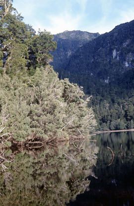
Part of Arthur Knight Slides
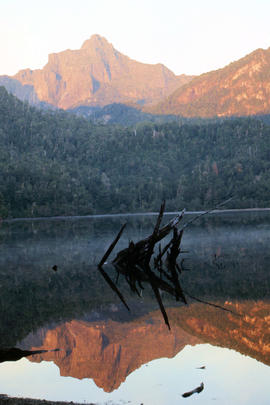
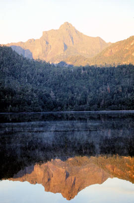
Colour photograph shows Lake Lea in foreground, with Cradle Mountain and Barn Bluff in distance
Part of Arthur Knight Slides
Colour photograph shows Lake Lea in foreground, with Cradle Mountain and Barn Bluff in distance

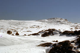
Part of Arthur Knight Slides
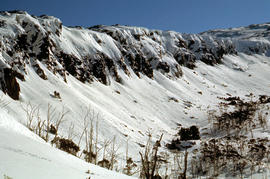
Colour photograph shows flecks of snow on upper ridges of Cradle Mountain and land around Dove Lake, some of it cloaked in deep shadow

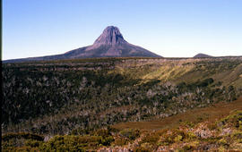
Cradle Mountain from Hansons Peak
Part of Arthur Knight Slides
Colour photograph of Cradle Mountain as viewed from nearby Hansons Peak

Part of Arthur Knight Slides
Colour photograph shows shoreline of Crater Lake with sunlit cliffs on opposite bank

Part of Arthur Knight Slides
Colour photograph shows Volkswagen combi van being driven through floodwaters across Midland Highway 1964

Snow on banks of River Derwent 1986
Part of Arthur Knight Slides
Colour photograph shows snow on the shoreline of River Derwent 1986

Part of Arthur Knight Slides
Colour photograph shows icicles formed on Little Horn 1985

Lake Loane under snow cover 1978
Part of Arthur Knight Slides
Colour photograph shows Lake Loane beneath blanket of snow, from near the Horse Track 1978

Part of Arthur Knight Slides
Colour photograph shows waves and white caps on the surface of Lake Myrtle GIS: Latitude -4188 Longitude 14618 Gazetteer Australia Record_ID TAS02073
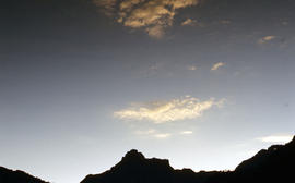
Part of Arthur Knight Slides
Colour photograph shows silhouette of Mount Anne, viewed at sunset
Part of Arthur Knight Slides
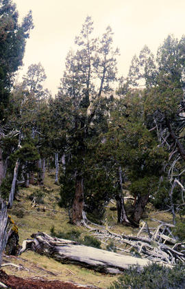
Colour photograph shows Pencil Pines growing in alpine forest near Dixons Kingdom hut
Tarn and Pencil Pines near Mountains of Jupiter
Part of Arthur Knight Slides
Colour photograph shows alpine vegetation surrounding Pool of Bethesda GIS: Latitude -4181 Longitude 14630 Gazetteer Record_ID TAS12063
Part of Arthur Knight Slides
Colour photograph shows patterned bark of snow gum near Cathedral Mountain
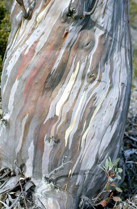
Bark of snow gum near Cathedral Mountain
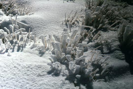
Part of Arthur Knight Slides
Colour photograph shows ice formations on tufts of native grass
Part of Arthur Knight Slides
Colour photograph shows snow covering alpine vegetation
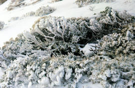
Part of Arthur Knight Slides
Colour photograph shows snow cover around Mount Rogoona
Snow on plateau below Mount Rogoona
Part of Arthur Knight Slides
Colour photograph shows southern shore of Lake Timk
Summit of West Wall at Mount Jerusalem
Part of Arthur Knight Slides
Colour photograph shows sunrise at Cradle Mountain 1976
Part of Arthur Knight Slides
Colour photograph shows view of mountain range to the west of Mount Field West
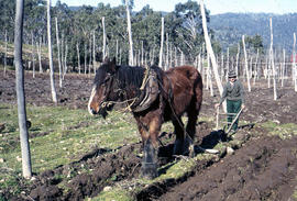
Man and horse ploughing at Westerway
Part of Arthur Knight Slides
Colour photograph shows a farmer ploughing a paddock at Westerway in a field strung with trellis frames for hop cultivation with a draught horse and plough
Part of Arthur Knight Slides
Colour photograph shows a bushwalker fighting to stay upright in the current while fording Sandfly Creek
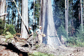
Timber workers tree felling in Florentine Valley
Part of Arthur Knight Slides
Colour photograph shows two bushmen, one using a chainsaw
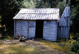
Part of Arthur Knight Slides
Colour photograph shows timber paling bush hut in clearing, with words DAMPER INN THAN OUT
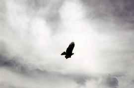
Part of Arthur Knight Slides
Colour photograph shows silhoutte of eagle in flight against a cloudy sky
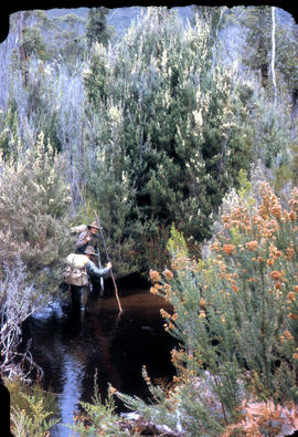
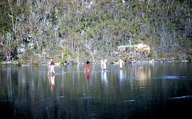
Two bushwalkers testing the waters
Part of Arthur Knight Slides
Colour photograph shows two men testing the creekbed in tea trea heathland
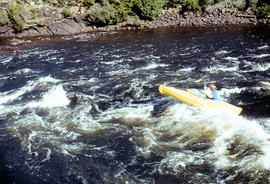
Paddler on whitewater course at Bradys Lake
Part of Arthur Knight Slides
Colour photograph shows paddler on whitewater course on Woodwards Canal, a man-made water course carved between Bradys Lake and Bronte Lagoon by the Hydro Electric Commission during construction of a hydro-electric power scheme
Timber worker scales tree in Florentine Valley
Part of Arthur Knight Slides
Colour portrait format photograph shows a timber worker climbing at tree in the Florentine Valley to chop down the head of the tree by hand
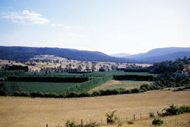
Hop fields and oast house near Rosegarland
Part of Arthur Knight Slides
Colour photograph shows hop fields, timber huts and oast house near Rosegarland
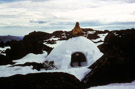
Part of Arthur Knight Slides
Colour photograph shows two bearded men posing on the top or in doorway of an igloo built at Mount Field West, 1975
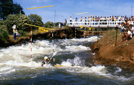
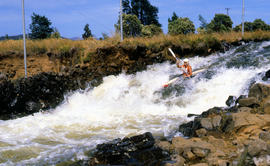
Kayak slalom paddler Jonathan Males
Part of Arthur Knight Slides
Colour photograph shows Australian K1 champion Jonathan Males, a Tasmanian paddler competing at Bradys Lake slalom course, watched by several spectators on a bridge above and alongside the course. The course on Woodwards Canal, a man-made water course carved between Bradys Lake and Bronte Lagoon by the Hydro Electric Commission during construction of a hydro-electric power scheme
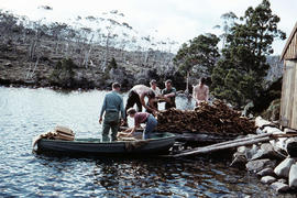
Loading firewood at Lake Dobson
Part of Arthur Knight Slides
Colour photograph shows six people loading sawn timber offcuts into a small dinghy on the edge of Lake Dobson
Part of Arthur Knight Slides
Colour photograph shows surface of Lake Dobson
People skating on Lake Dobson 1954
Part of Arthur Knight Slides
Colour photograph shows people skating on frozen surface of Lake Dobson, 1954
Part of Arthur Knight Slides
Colour photograph shows man standing on a ridge on Mount Lord, looking across the Lawrence valley, where the Lawrence Rivulet flows. Man is standing amid tall specimens of Pandani, Richea pandanifolia.
Mount Eliza covered in low cloud
Part of Arthur Knight Slides
Colour photograph shows lightly timbered heath and woodland and Mount Eliza in the background covered in low cloud
Ice-covered shrubs on Mount Mawson
Part of Arthur Knight Slides
Colour photograph shows ice formation on branches of shrub at Mount Mawson
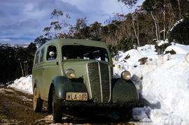
Vehicle on road at National Park
Part of Arthur Knight Slides
Colour photograph shows two-tone green vehicle with driver's fingers visible on steering wheel, on the unsealed road at National Park, with snow covering the higher ground. Tasmanian number plate reads WLA 189 - 19 TAS 56.
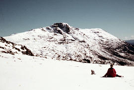
Walker sits on snow near Naturalist Peak
Part of Arthur Knight Slides
Colour photograph shows person sitting on the snow near Naturalist Peak
Part of Arthur Knight Slides
Colour photograph shows three people resting at Newdegate Pass in Mount Field National Park
Rigger in the Florentine Valley
Part of Arthur Knight Slides
Colour photograph shows timber worker wearing hard hat, chaps and holding ropes and an axe, standing on fallen logs in the Florentine Valley
Part of Arthur Knight Slides
Colour photograph shows the rusting red roofing iron on hut visible above trees on the edge of Twilight Tarn
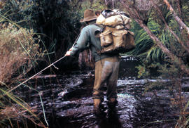
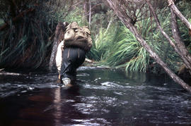
Part of Arthur Knight Slides
Colour photograph shows bushwalker with backpack wading through Sandfly Creek
Part of Arthur Knight Slides
Colour photograph shows two people standing upright on the frozen surface of Lake Dobson, 1954
Part of Arthur Knight Slides
Colour photograph of Barn Bluff and Cradle Cirque

Reflection of mountain on surface of Dove Lake
Part of Arthur Knight Slides
Colour photograph shows light dusting of snow on Cradle Mountain, visible also from reflection in Dove Lake in foreground

Reflection of mountain on still surface of Dove Lake
Part of Arthur Knight Slides
Colour photograph shows reflection of Cradle Mountain on surface of Dove Lake Image of mountain slightly out of focus

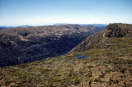
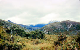
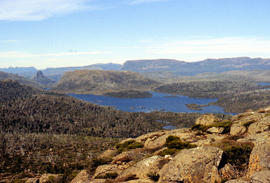
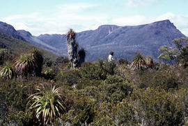
Looking south to Cradle Mountain
Part of Arthur Knight Slides
Colour photograph shows the heathland on the Central Plateau, south of Cradle Mountain, with the mountain peaks visible in the distance

Part of Arthur Knight Slides
Colour photograph shows bed of green and red cushion plants

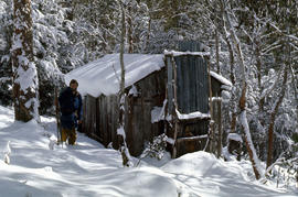
Alpine hut covered in snowdrift
Part of Arthur Knight Slides
Colour photograph shows footprints in snow leading to an alpine hut in a clearing, partially covered by snowdrift

Part of Arthur Knight Slides
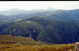
Colour photograph shows alpine plateau, valley and Eldon and Tyndall ranges in distance

Part of Arthur Knight Slides
Colour photograph shows hut at Lake Meston built of logs, shingles and with tin plate chimney People sitting outside hut eating

Ice formation near Herods Gate 1978
Part of Arthur Knight Slides
Colour photograph shows ice formation on cliff face near Herods Gate, with snow covering alpine vegetation

Part of Arthur Knight Slides
Colour photograph shows snow at Jaffa Vale

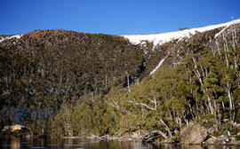
Part of Arthur Knight Slides
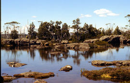
Colour photograph shows shoreline of Lake Adelaide

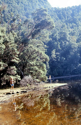
Lake Lea from Prospect Mountain
Part of Arthur Knight Slides
Colour photograph shows Lake Lea from Prospect Mountain near Vale of Belvoir

Reflections upon surface of Lake Chalice 1979
Part of Arthur Knight Slides
Colour photograph shows reflections of alpine vegetation in Chalice Lake 1979 GIS: Lake Latitude -4188 Longitude 14615 Gazetteer Australia Record_ID TAS02044
Part of Arthur Knight Slides
Colour photograph shows afternoon reflection of Mount Anne on the surface of water of Lake Timk
Portrait format view of reflection of Mount Anne on surface of Lake Timk
Part of Arthur Knight Slides
Colour photograph shows peaks in the Du Cane mountain range including Mount Geyron, as viewed from Cathedral Mountain
Mount Ida and Lake Payanna 1979
Part of Arthur Knight Slides
Colour photograph shows cloud encircling Mount Ossa and clear skies around nearby Cathedral Mountain
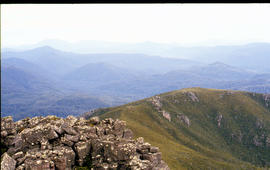
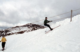
View from Mount Murchison to Mount Heemskirk
Part of Arthur Knight Slides
Colour photograph shows snow skier at Piesse Vale on Ben Lomond plateau GIS Latitude -4154 Longitude 14763 Gazetteer Record_ID TAS13722 Source: https://wwwparkstasgovau/fileaspx?id=6392
Part of Arthur Knight Slides
Colour photograph shows man in skis atop snow-covered roof of Dixons Kingdom hut
Snow formation at Jaffa Gate 1978
Part of Arthur Knight Slides
Colour photograph shows snow near summit of Ben Lomond 1962
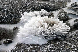
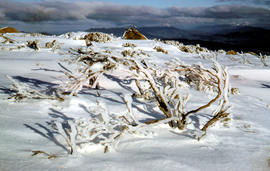
Snow and ice formations on tufts of grass
Part of Arthur Knight Slides
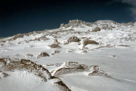
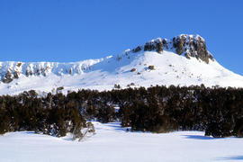
Colour photograph shows snow atop Mount Ophel
Southern shore of Lake Timk 1974
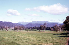
Part of Arthur Knight Slides
Colour photograph shows view of Stacks Bluff from open paddocks and farmland at Mangana
Part of Arthur Knight Slides
Colour photograph shows snow cover on Stacks Bluff, photographed from nearby forest Low contrast in image
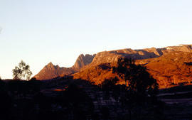
Sunrise at Cradle Mountain, photographed 1976
Part of Arthur Knight Slides
Colour photograph shows snow vehicle travelling uphill south west of the summit of Ben Lomond
Part of Arthur Knight Slides
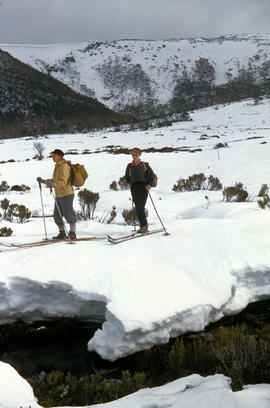
Colour photograph shows skier standing outside trapper's hut in the snow
Part of Arthur Knight Slides
Colour photograph shows three snow skiers outside a trapper's hut in the snow
Snow cover on Wailing Wall near Mount Jerusalem
Part of Arthur Knight Slides
Colour photograph shows lilies on surface of Lake Meston
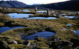
People on shore of Lake Timk 1974
Part of Arthur Knight Slides
Colour photograph shows people on western shore of Lake Timk 1974
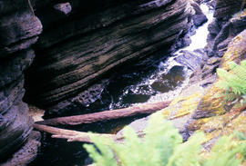
Water flowing in base of Leven Canyon
Part of Arthur Knight Slides
Colour photograph shows logs in base of Leven Canyon
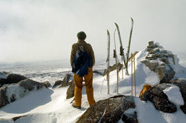
Snow skier on Mt Jerusalem 1978
Part of Arthur Knight Slides
Colour photograph shows snow skier standing on Mount Jerusalem, near the West Wall summit
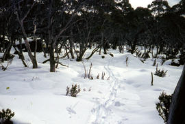
Track to Lakes Belton and Bercher under snow
Part of Arthur Knight Slides
Colour photograph shows footsteps in the snow on the track to Lake Belton and Lake Belcher
Part of Arthur Knight Slides
Colour photograph shows man paddling kayak on Derwent River near site of Repulse Dam
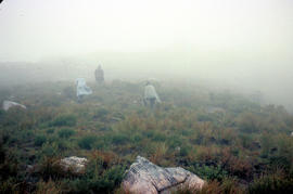
Part of Arthur Knight Slides
Colour photograph shows three walkers on heathland climbing in fog
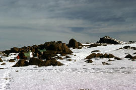
Part of Arthur Knight Slides
Colour photograph shows tents pegged on snow covered ground at Mount Field West
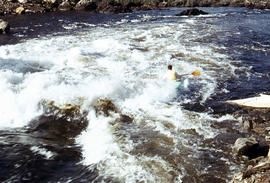
Kayaking in rapids of Derwent River
Part of Arthur Knight Slides
Colour photograph shows a lone kayaker navigating whitewater on the Derwent River below the Repulse Dam site
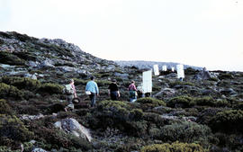
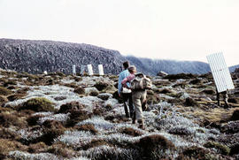
Walkers carrying roofing iron to K Col
Part of Arthur Knight Slides
Colour photograph shows bushwalkers carrying roofing iron along a path to the ridgeline of K Col near Mount Field West as part of project to build a hut to shelter bushwalkers and skiers. Hobart Walking Club's F.A. Peterson Memorial Hut was opened in 1960
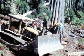
Caterpillar bulldozer in Florentine Valley
Part of Arthur Knight Slides
Colour photograph shows Caterpillar Diesel D7 series bulldozer and timber workers at the base of a tree being felled by chainsaw in the Florentine Valley
Part of Arthur Knight Slides
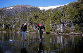
Colour photograph shows man and woman standing on frozen surface of Eagle Tarn, with snow-topped mountain ridge in distance
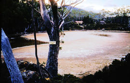
Part of Arthur Knight Slides
Colour photograph shows partially dry lakebed of Eagle Tarn, in Mount Field National Park, with hut visible on the opposite shoreline. Sign nailed to tree reads: EAGLE TARN 3390FT
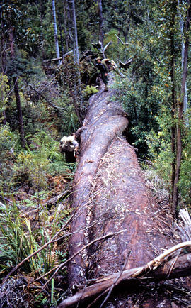
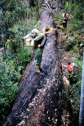
Bushwalkers clamber on fallen tree
Part of Arthur Knight Slides
Colour photograph shows bushwalkers climbing on or standing beside trunk of fallen tree
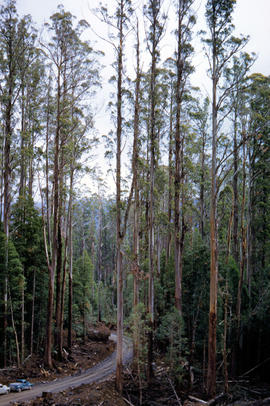
Gravel road in Florentine Valley
Part of Arthur Knight Slides
Colour photograph shows gravel road in Florentine Valley
Part of Arthur Knight Slides
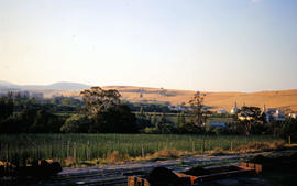
Colour photograph shows hop fields, farm buildings and dwellings at Glenora, 1959
Part of Arthur Knight Slides
Colour photograph shows low cloud obscuring the forest and ridgelines where Lake Edgar is visible in the distance
Part of Arthur Knight Slides
Colour photograph shows Lake Fenton
Bushwalkers stand atop and beside fallen tree
Part of Arthur Knight Slides
Colour photograph shows bushwalkers atop or standing beside a fallen tree
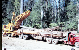
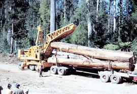
Loading a semi-trailer with logs in Florentine Valley
Part of Arthur Knight Slides
Colour photograph shows a crane being used to load up a semi-trailer to carry logs from the Florentine Valley. inscription on driver's door reads, L.J. Reynolds, HAULAGE CONTRACTOR, Maydena, Phone 217
Bark peels off log being loaded onto semi-trailer
Part of Arthur Knight Slides
Colour photograph shows a timber work cast in shadow as a log is lifted by a crane being used to load up a semi-trailer to carry logs from the Florentine Valley. Inscription on driver's door reads L.J. Reynolds, HAULAGE CONTRACTOR, Maydena, Phone 217
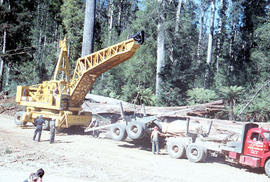
Logs from the Florentine Valley
Part of Arthur Knight Slides
Colour photograph shows a crane being used to load logs on a semi-trailer in the Florentine Valley. Inscription on driver's door reads L.J. Reynolds, HAULAGE CONTRACTOR, Maydena, Phone 217. Visible at lower left of image are people in street or travelling clothes on an outing to view timber workers in the bush
Part of Arthur Knight Slides
An aerial colour photograph shows distinctive shelter belts around cultivated hop fields alongside River Derwent at Bushy Park, Glenora and Macquarie Plains. Long shadows being cast from the low sun to the west
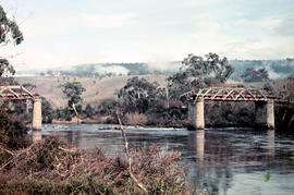
Gap across River Derwent at Macquarie Plains bridge
Part of Arthur Knight Slides
Colour photograph shows gap in the railway track at Macquarie Plains railway bridge
Part of Arthur Knight Slides
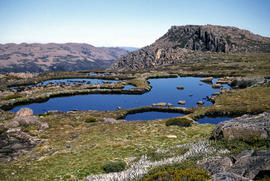
Colour photograph shows small tarns on alpine plateau at Mount Field West
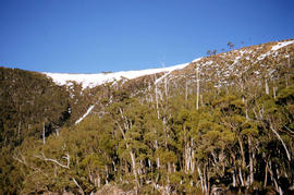
Trees on slope of Mount Mawson
Part of Arthur Knight Slides
Colour photograph shows mature forest, amid some patches of dead tree cover, on steep slope at base of Mount Mawson
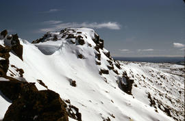
Ridgeline of Mount Mawson as viewed from Lake Dobson
Part of Arthur Knight Slides
Colour photograph shows snow on the ridgeline of Mount Mawson as viewed from Lake Dobson
Storm approaches Mount Solitary
Part of Arthur Knight Slides
Colour photograph shows storm approaching Mount Solitary
Part of Arthur Knight Slides
Colour photograph shows two snow skiiers navigating patchy snow at National Park, a location in Mount Field National Park
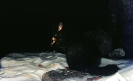
Part of Arthur Knight Slides
Colour photograph shows a possum eating something in the snow at Lake Dobson 1968
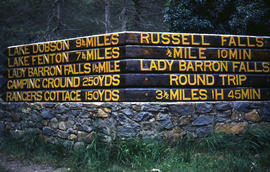
Part of Arthur Knight Slides
Colour photograph shows Russell Falls as viewed from elevated vantage point in rainforest
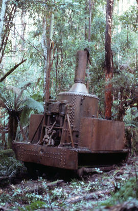
Four men standing around Skagit loader
Part of Arthur Knight Slides
Colour photograph shows timber workers in hard hats standing around an unladen Skagit loader with an operator visible in the cabin, on a dirt track in the bush