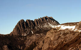
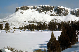
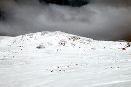
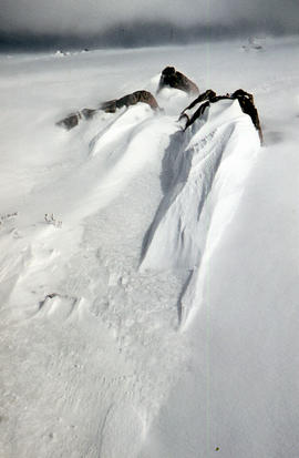
Summit of Cradle Mountain 1976
- AU TAS UTAS ITCCD 2017/2-362
- Unidad documental simple
- 1976
Parte deArthur Knight Slides
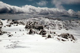
Colour photograph shows summit of West Wall, at Mount Jerusalem
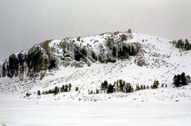
Summit of Cradle Mountain 1976
Parte deArthur Knight Slides
Colour photograph shows summit of West Wall, at Mount Jerusalem
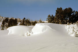
Parte deArthur Knight Slides
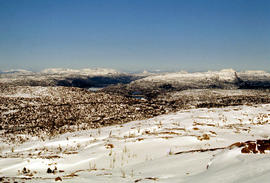
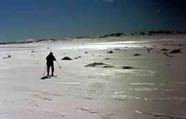
Colour photograph shows snow on upper ridgeline of Cradle Mountain 1976
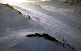
Summit from Ben Lomond plateau 1960
Parte deArthur Knight Slides
Colour photograph shows snow cover near summit of Ben Lomond
Snow cover on Ben Lomond plateau near summit 1960
Parte deArthur Knight Slides
Colour photograph shows summit of Ben Lomond 1962
Strickland Valley from Ben Lomond 1960
Parte deArthur Knight Slides
Colour photograph shows summit of Ben Lomond
Parte deArthur Knight Slides
Colour photograph shows snow cover on Stacks Bluff, photographed from nearby forest Low contrast in image
Parte deArthur Knight Slides
Colour photograph of Strickland Valley near Ben Lomond, with partial snow cover, 1960
Southern shore of Lake Timk 1974
Parte deArthur Knight Slides
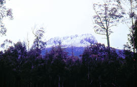
Colour photograph shows view of Stacks Bluff from open paddocks and farmland at Mangana
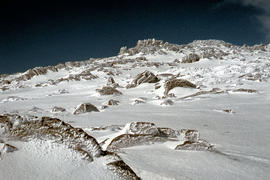
Snow on plateau below Mount Rogoona
Parte deArthur Knight Slides
Colour photograph shows southern shore of Lake Timk
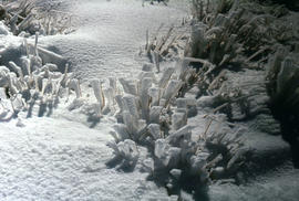
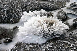
Snow and ice formations on tufts of grass
Parte deArthur Knight Slides
Colour photograph shows snow atop Mount Ophel
Parte deArthur Knight Slides
Colour photograph shows snow cover around Mount Rogoona
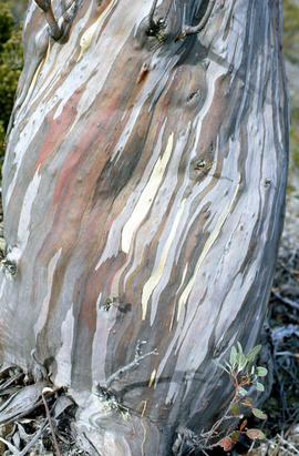
Bark of snow gum near Cathedral Mountain
Parte deArthur Knight Slides
Colour photograph shows ice formations on tufts of native grass
Parte deArthur Knight Slides
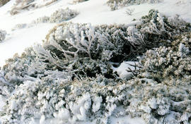
Colour photograph shows snow covering alpine vegetation
Snow formation at Jaffa Gate 1978
Parte deArthur Knight Slides
Colour photograph shows snow near summit of Ben Lomond 1962
Parte deArthur Knight Slides
Colour photograph shows patterned bark of snow gum near Cathedral Mountain
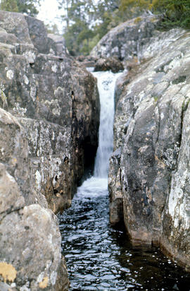
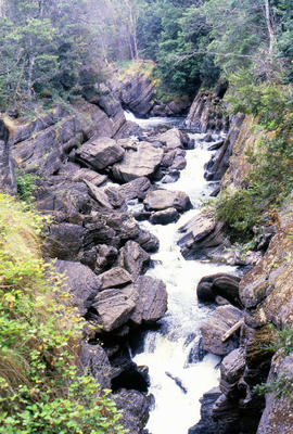
Small waterfall above Grail Falls
Parte deArthur Knight Slides
Colour photograph shows snow formation at Jaffa Gate
Snow formation near summit of Ben Lomond 1962
Parte deArthur Knight Slides
Colour photograph shows snow formations
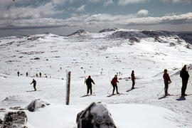
Ski runs near summit of Ben Lomond 1960
Parte deArthur Knight Slides
Colour photograph of waterfall and rocky channel above Grail Falls GIS: Latitude -4187 Longitude 14616 Gazetteer Record_ID TAS19534
Parte deArthur Knight Slides
Colour photograph shows ski runs near summit of Ben Lomond 1960
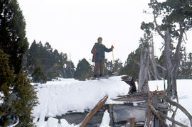
Skiing on the roof of Dixons Kingdom
Parte deArthur Knight Slides
Colour photograph shows buildings on Ben Lomond
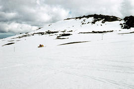
Snow vehicle near summit of Ben Lomond
Parte deArthur Knight Slides
Colour photograph shows Temple and West Wall, at Mount Jerusalem
Parte deArthur Knight Slides
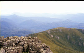
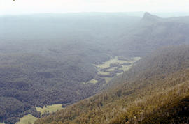
Colour photograph shows view of forest and mountain ranges from Mayday Mountain
Parte deArthur Knight Slides
Colour photograph shows man in skis atop snow-covered roof of Dixons Kingdom hut
Pool of Siloam & The Temple 1978
Parte deArthur Knight Slides
Colour photograph shows snow covering Pool of Siloam near the West Wall of Mount Jerusalem
Pool of Siloam and the West Wall of Mount Jerusalem
Parte deArthur Knight Slides
Colour photograph shows dolerite peak of Ragged Jack, near Ben Lomond, viewed across from lightly timbered farmland
Parte deArthur Knight Slides
Colour photograph shows snow covering the Pool of Siloam near The Temple below Mount Jerusalem
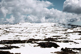
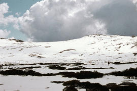
Plateau near summit of Ben Lomond
Parte deArthur Knight Slides
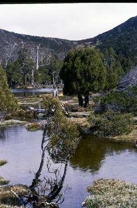
Colour photograph shows reflections of alpine vegetation in tarn near Mountains of Jupiter
Tarn and Pencil Pines near Mountains of Jupiter
Parte deArthur Knight Slides
Colour photograph shows alpine vegetation surrounding Pool of Bethesda GIS: Latitude -4181 Longitude 14630 Gazetteer Record_ID TAS12063
Parte deArthur Knight Slides
Colour photograph shows creek running through snow and ice on plateau above Cradle Mountain
Creek on plateau above Cradle Mountain
Parte deArthur Knight Slides
Colour photograph shows plateau near summit of Ben Lomond
Piesse Vale on Ben Lomond plateau
Parte deArthur Knight Slides
Colour photograph shows plateau near Cradle Mountain
Parte deArthur Knight Slides
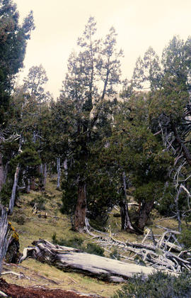
Colour photograph shows Pencil Pines growing in alpine forest near Dixons Kingdom hut
Parte deArthur Knight Slides
Colour photograph shows whitewater section of Pencil Pine Creek
Pencil Pines near Dixons Kingdom
Parte deArthur Knight Slides
Colour photograph shows Piesse Vale at Ben Lomond plateau dusted with snow GIS Latitude -4154 Longitude 14763 Gazetteer Record_ID TAS13722
Snow cover at near Walls of Jerusalem looking to Mount Olympus and Mount Gould
Parte deArthur Knight Slides
Colour photograph shows snow skier standing on Mount Jerusalem

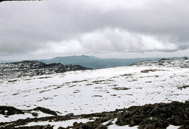
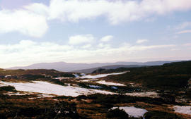
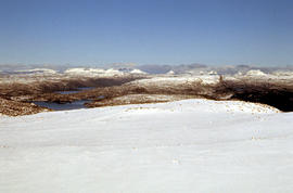
View across Cradle Mountain ridges to the north
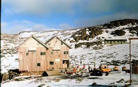
Parte deArthur Knight Slides
Colour photograph shows people standing outside Northern Tasmanian Alpine Club hut at Ben Lomond, one holding snow skis and poles
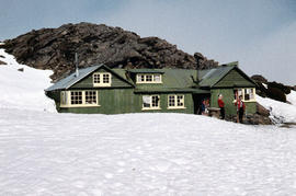
Northern Tasmanian Alpine Club hut on Ben Lomond
Parte deArthur Knight Slides
Colour photograph shows snow cover near Walls of Jerusalem looking to Mount Olympus and Mount Gould
Parte deArthur Knight Slides
Colour photograph of view from snow capped Cradle Mountain looking north
View from Mount Murchison to Mount Heemskirk
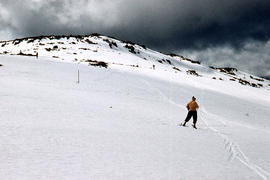
Parte deArthur Knight Slides
Colour photograph shows snow skier at Piesse Vale on Ben Lomond plateau GIS Latitude -4154 Longitude 14763 Gazetteer Record_ID TAS13722 Source: https://wwwparkstasgovau/fileaspx?id=6392
Parte deArthur Knight Slides
Colour photograph shows cloud above mountain ranges, looking west to Mount Heemskirk from Mount Murchison

Parte deArthur Knight Slides
Colour photograph shows Mount Rogoona with Lake Myrtle obscured by light alpine forest vegetation on ridge

Panoramic view of Mount Rogoona
Parte deArthur Knight Slides
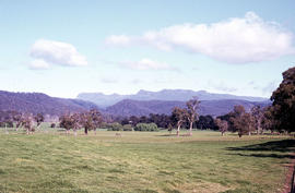
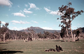
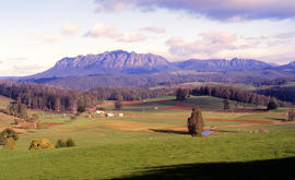
Colour photograph shows farmland in the Kentish area with Mount Roland in background
Mount Ida and Lake Payanna 1979
Parte deArthur Knight Slides
Colour photograph shows cloud encircling Mount Ossa and clear skies around nearby Cathedral Mountain

Mount Ossa and Cathedral Mountain
Parte deArthur Knight Slides
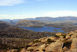
Colour photograph shows rocky peak of Mount Rogoona, with alpine plain in foreground

Mount Geyron from Cathedral Mountain
Parte deArthur Knight Slides
Colour photograph shows Lake Payanna and Mount Ida

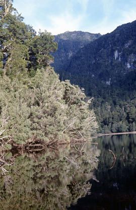
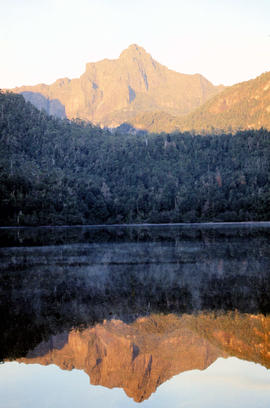
Reflection of Mount Anne on surface of Lake Timk
Parte deArthur Knight Slides
Colour portrait format photograph shows reflection of Mount Anne on the surface of Lake Timk
Parte deArthur Knight Slides
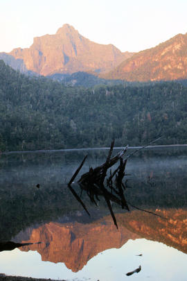
Colour photograph shows afternoon reflection of Mount Anne on the surface of water of Lake Timk
Portrait format view of reflection of Mount Anne on surface of Lake Timk
Parte deArthur Knight Slides
Colour photograph shows peaks in the Du Cane mountain range including Mount Geyron, as viewed from Cathedral Mountain
Parte deArthur Knight Slides
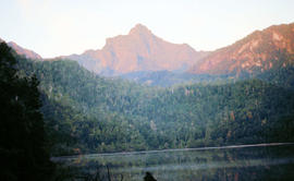
Colour photograph shows Mount Anne at sunrise as viewed from across Lake Timk
Parte deArthur Knight Slides
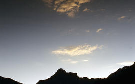
Colour photograph shows silhouette of Mount Anne, viewed at sunset
Cliffs of Mount Anne above Lake Timk
Parte deArthur Knight Slides
Colour photograph shows the cliffs of Mount Anne above Lake Timk

Parte deArthur Knight Slides
Colour photograph shows Lake Timk and Mount Anne in distance GIS: Latitude -4293 Longitude 14646 Gazetteer Australia Record_ID TAS16882

Walkers on Mountains of Jupiter
Parte deArthur Knight Slides
Colour photograph of bushwalkers at Mountains of Jupiter near the Walls of Jerusalem
Snow skiers on Ben Lomond 1962
Parte deArthur Knight Slides
Colour photograph shows snow skiing on Ben Lomond at Markham Heights
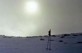
Morning mist on Ben Lomond 1962
Parte deArthur Knight Slides
Colour photograph shows pair of gloves on a set of ski poles pitched into snow atop Ben Lomond, with mist covering the sun

Parte deArthur Knight Slides
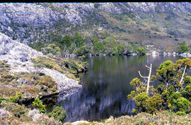
Colour portrait format photograph shows Lake Wilks and Little Horn near Cradle Mountain
Parte deArthur Knight Slides
Colour photograph shows whitewater in narrow section of Leven Canyon
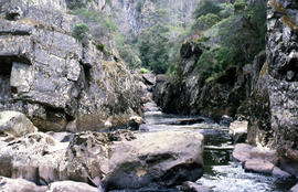
Parte deArthur Knight Slides
Colour photograph shows rockpools in the Leven River at Leven Canyon, surrounded by steep rockwalls and temperate rainforest
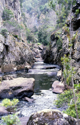
Portrait format photograph of Leven Canyon
Parte deArthur Knight Slides
Colour portrait format photograph shows Leven River spilling in to narrow gorge in the part of the river known as Leven Canyon
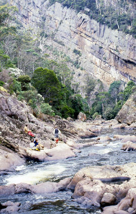
Sitting on ledge beside Leven River
Parte deArthur Knight Slides
Colour photograph shows walkers resting on rock ledge beside Leven River in the Leven Canyon
Parte deArthur Knight Slides
Colour photograph shows Legges Tor, the highest peak of Ben Lomond, with skiers visible on the nearby ski field
Lees Paddock and Mount Pillinger
Parte deArthur Knight Slides
Colour photograph shows the cleared land of Lees Paddocks in the upper Mersey Valley, surrounded by bush with Mount Pillinger in the background

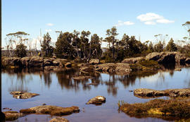
Shoreline of Lake Chalice 1979
Parte deArthur Knight Slides
Colour photograph shows the rocky shoreline of Chalice Lake GIS: Latitude -4188 Longitude 14615 Gazetteer Australia Record_ID TAS02044

Parte deArthur Knight Slides
Colour photograph shows waves and white caps on the surface of Lake Myrtle GIS: Latitude -4188 Longitude 14618 Gazetteer Australia Record_ID TAS02073

Reflections upon surface of Lake Chalice 1979
Parte deArthur Knight Slides
Colour photograph shows reflections of alpine vegetation in Chalice Lake 1979 GIS: Lake Latitude -4188 Longitude 14615 Gazetteer Australia Record_ID TAS02044

Lake Loane under snow cover 1978
Parte deArthur Knight Slides
Colour photograph shows Lake Loane beneath blanket of snow, from near the Horse Track 1978

Parte deArthur Knight Slides
Colour photograph shows shoreline of Lake Adelaide

Lake Lea from Prospect Mountain
Parte deArthur Knight Slides
Colour photograph shows Lake Lea from Prospect Mountain near Vale of Belvoir

Parte deArthur Knight Slides
Colour photograph shows snow at Jaffa Vale

Parte deArthur Knight Slides
Colour photograph of limited water flow across Knyvet Falls 1984 GIS: Latitude -4159 Longitude 14593 Gazetteer Australia Record_ID TAS06008

Snowfall at Jaffa Vale and Mount Olympus
Parte deArthur Knight Slides
Colour photograph shows tracks of snow skiers at Jaffa Vale and Mount Olympus

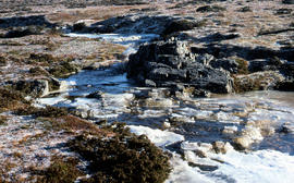
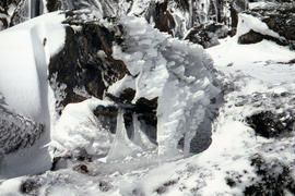
Ice formation near Herods Gate 1978
Parte deArthur Knight Slides
Colour photograph shows ice formation on cliff face near Herods Gate, with snow covering alpine vegetation

Parte deArthur Knight Slides
Colour photograph shows icicles formed on Little Horn 1985

Parte deArthur Knight Slides
Colour photograph shows ice formed on plants, location unknown
Ice formation on rocks at Ben Lomond 1962
Parte deArthur Knight Slides
Colour photograph shows ice formation on rocks atop Ben Lomond 1962

Parte deArthur Knight Slides
Colour photograph shows hut at Lake Meston built of logs, shingles and with tin plate chimney People sitting outside hut eating

Snow on banks of River Derwent 1986
Parte deArthur Knight Slides
Colour photograph shows snow on the shoreline of River Derwent 1986

Parte deArthur Knight Slides
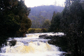
Colour photograph shows Grail Falls
Parte deArthur Knight Slides
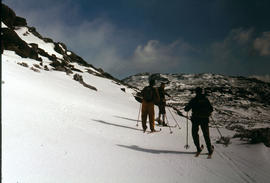
Colour photograph shows three snow skiers on Ben Lomond 1977
Parte deArthur Knight Slides
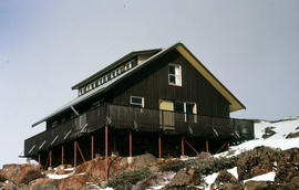
Colour photograph shows Foresters hut on Ben Lomond 1977

Wildflowers on Cathedral Mountain
Parte deArthur Knight Slides
Colour photograph of wildflower in alpine environment

Parte deArthur Knight Slides
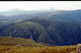
Colour photograph shows alpine plateau, valley and Eldon and Tyndall ranges in distance

Parte deArthur Knight Slides
Colour photograph shows Volkswagen combi van being driven through floodwaters across Midland Highway 1964

Du Cane Range and Mount Ossa under snow
Parte deArthur Knight Slides
Colour photograph of Du Cane Range and Mount Ossa

Du Cane Range from Mountains of Jupiter
Parte deArthur Knight Slides
Colour photograph shows Du Cane Range as viewed from Mountains of Jupiter
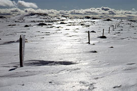
Snowdrift against rocks at Ben Lomond
Parte deArthur Knight Slides
Colour photograph shows snowdrift against rocks on Ben Lomond 1962

Parte deArthur Knight Slides
Colour photograph shows two sets of skis and backpacks outside an alpine hut, covered in a snowdrift

Alpine hut covered in snowdrift
Parte deArthur Knight Slides
Colour photograph shows footprints in snow leading to an alpine hut in a clearing, partially covered by snowdrift
Parte deArthur Knight Slides
Colour photograph shows wind moving snow in drift at sunset on Ben Lomond 1962

Parte deArthur Knight Slides
Colour photograph shows bed of green and red cushion plants

Parte deArthur Knight Slides
Colour photograph shows bed of green cushion plants

Parte deArthur Knight Slides
Colour photograph shows a steel-plated culvert beneath a road at Foggs Flat

Parte deArthur Knight Slides
Colour photograph shows Crater Lake

Pencil Pines on shore of Crater Lake
Parte deArthur Knight Slides
Colour photograph shows Crater Lake, with remnants of snow on rock ledge

Parte deArthur Knight Slides
Colour photograph shows shoreline of Crater Lake with sunlit cliffs on opposite bank

Parte deArthur Knight Slides
Colour photograph shows ridge of rock from Dove Lake
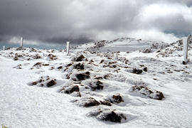
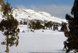
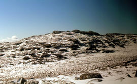
Snow cover on Ben Lomond Plateau
Parte deArthur Knight Slides
Colour photograph shows snow cover on Ben Lomond Plateau

Cradle Mountain from Hansons Peak
Parte deArthur Knight Slides
Colour photograph of Cradle Mountain as viewed from nearby Hansons Peak

View of Cradle Mountain ridgeline from Hansons Peak
Parte deArthur Knight Slides
Colour photograph of Cradle Mountain from Hansons Peak

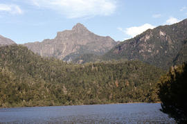
Cradle Mountain from Dove Lake
Parte deArthur Knight Slides
Colour photograph shows light dusting of snow on Cradle Mountain from Dove Lake