Aperçu avant impression Fermer

Affichage de 1774 résultats

Description archivistique
Tasmania Pièce
Aperçu avant impression Affichage :

1389 résultats avec objets numériques Afficher les résultats avec des objets numériques

1863-66: Farm Journal

Farm journal for Kelvedon, June 1863 to March 1866. For the years 1867-9 see also Sheep Record 1866-70 (36)

Francis Cotton

Ruins of church at Port Arthur

Black-and-white photograph shows ruins of the church at Port Arthur, damaged by fire in 1884,with charred timber framework in the roof, remnant shingles on the roof and climbing plants covering the sandstone of the church walls. Handwritten words “Church at Port Arthur” in lower left corner of image.

Family photographs

  • AU TAS UTAS SPARC F6-25
  • Pièce
  • 1916-1932
  • Fait partie de Fuller Papers

Family photographs including portraits and snapshots of W. E. Fuller and family including: Early photographs of W. E. Fuller as a boy, groups, 2 girls (1 reading, 1 preparing veg.) Margaret and Mary (daughters of W.E.F.) as babies and toddlers, family groups (including family group Xmas 1918 including grandparents). Snapshots of army days (1916-18), enlarged photo of army ordnance office at work. Formal portraits, various dates, Mr. and Mrs. W. E. Fuller broadcasting for A.B.C. c. 1932.

William Edwin Fuller

Photograph of Roydon

Photograph of front view of Roydon, Broadmarsh. Taken April 1960. Located at 58 Clifton Vale Road, Elderslie. Sandstone farm house with a central door and flanking double hung windows, an attic level and weatherboard addition to the rear. The building has a hipped roof and narrow boxed eaves. The sandstone stables feature a half hipped roof, sandstone walls and an iron roof. The building is a floor and a half and is still in use as a stable. There are some other early buildings on the site.

Shoreline of Cloister Lagoon

Colour photograph shows shoreline of Cloister Lagoon GIS: Latitude -4189 Longitude 14617 Gazetteer Australia Record_ID TAS02046

Looking south to Cradle Mountain

Colour photograph shows the heathland on the Central Plateau, south of Cradle Mountain, with the mountain peaks visible in the distance

Cradle Mountain and Dove Lake

Colour photograph shows flecks of snow on upper ridges of Cradle Mountain and land around Dove Lake, some of it cloaked in deep shadow

View across Lake Lea

Colour photograph shows Lake Lea in foreground, with Cradle Mountain and Barn Bluff in distance

Unidentified photographs

Collection of unidentified photographs, some of hospitals and staff and some of maritime personnel. Pre- World War One photographs belonging to G.M Parker which were taken in London. These photographs include group portraits of medical staff at St. Bartholomew’s Hospital. While many of the people in these photographs have not been identified, it is likely that Dr Parker features in some of them.

George Musgrave Parker

Theatrical photographs

  • AU TAS UTAS SPARC F6-26
  • Pièce
  • 1912-1940
  • Fait partie de Fuller Papers

Collection of photographs including Group in musical entertainment, including W. E. and Frances Fuller, c. 1912, with programme of "Entertainment by the Mountebanks", Moonah Mission Hall, 1912. W. E. Fuller portraying various parts (especially a rural character) for Hobart Repertory c. 1921 - 1940. Mary Fuller as Little Peter Saunders "Passers By", Theatre Royal 19~(part photograph, part
drawing by Jack Cato, framed.) Photos of broadcast for A.B.C. of "Mari.e Celeste" made on board "Lenna" in Derwent (1930s).

William Edwin Fuller

Photograph of Roydon

Photograph of the front door of Roydon, Broadmarsh. Taken April 1960. Located at 58 Clifton Vale Road, Elderslie. Sandstone farm house with a central door and flanking double hung windows, an attic level and weatherboard addition to the rear. The building has a hipped roof and narrow boxed eaves. The sandstone stables feature a half hipped roof, sandstone walls and an iron roof. The building is a floor and a half and is still in use as a stable. There are some other early buildings on the site.

Elevated view of church ruins at Port Arthur

Black-and-white photograph shows elevated view of ruined church at Port Arthur, including charred timber roof framework; with view of waterfront and other buildings on Port Arthur site; cut hay is drying in paddock at front of church.

Chapter 2 : Photographs with Dr. G.M. Parker's manuscript draft book

Photographs from chapter 2 :
• p6 Creek Hut, Meredith family's first house (photo of the drawing. See Pl/35(228» From Mace Papers Archives Office of Tasmania, (copy neg)
• p7 Cambria, Meredith residence. Beattie photo
• p8a Cranbrook House. Christmas card from "all at Cranbrook". ND
• p8b Cranbrook House. G.M.P. photo (& neg) 1929
• p8c Glen Gala. G.M.P. photo (&neg. See Pl/35(111) 1929

George Musgrave Parker

Chapter 7 : Photographs with Dr. G.M. Parker's manuscript draft book

Watercolours from chapter 7 :
• p3 "Waterloo Point". Watercolour on grey card. Endorsed "original was at Cambria dated 'Swansea 1852 R'. This copy was made by M.A. Walker 1928"
• p8 "Swanport" Watercolour on grey card. Copy by M.A. Walker of an original at Cambria: "F.M. to C.M. 1852"

George Musgrave Parker

Bookshop photographs

  • AU TAS UTAS SPARC F6-27
  • Pièce
  • 1909-1950
  • Fait partie de Fuller Papers

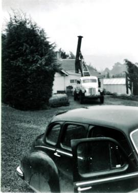
Book shop photographs. Library, probably Angus & Robertson, Sydney c. 1909 including Miss Frances Ruby Evans (later Mrs. W. E. Fuller) Collins Street, Arcade, W. E. and Mrs. Fuller and Miss C. Parker standing in front of opening in brickwork, 1930 (also cutting of Illustrated Tasmanian Mail, 3 December 1930). Snapshots of books being loaded on truck outside house and unloading outside
"Goodwill Store", Elizabeth Street (Fullers was in basement under "Goodwill") with negatives. c. 1932 - 1935 Tasmanian Book Club display, J. Walch &Sons. N.D. W. E. Fuller in Bookshelf Gallery.- Views in bookshop c. 1940 - 50. Booksellers' Conference
N.D. (c. 1930):­ Photo C. J. Frazer, Melbourne Photo (framed N.D. (?1930-40) Also snapshots of Booksellers' Conference,Hobart, (with negatives.)

William Edwin Fuller

1874: Pocket book diary

Pocket book diary dated 1874. E.O. Cotton (?): entries incluse notes on sheep gathering, shearing etc., bullocks, quarrying stone at Bend, carpentery work, work of Costello and Leckie, father & brothers, picnic on Hollyhock Hills, Belmont fence

Francis Cotton

Farm house

Photograph of farmhouse in rural setting, Verandah appears to be glassed in on at least two sides/

Graeme Raphael

Photograph of Roydon

Photograph of the front door of Roydon, Broadmarsh. Taken April 1960. Located at 58 Clifton Vale Road, Elderslie. Sandstone farm house with a central door and flanking double hung windows, an attic level and weatherboard addition to the rear. The building has a hipped roof and narrow boxed eaves. The sandstone stables feature a half hipped roof, sandstone walls and an iron roof. The building is a floor and a half and is still in use as a stable. There are some other early buildings on the site.

Skiing shelter

Colour photograph shows two sets of skis and backpacks outside an alpine hut, covered in a snowdrift

Tasmanian views

  • AU TAS UTAS SPARC F6-28
  • Pièce
  • n.d.
  • Fait partie de Fuller Papers

Collection of photographs of Tasmanian scenes. Panoramic view of Derwent River; Mount Wellington; Derwent river, yachts racing; Fitzpatrick' s Hotel at Westbury. Also postcard views of Hobart, New Norfolk, Miena Dam, Burnie, ships, N.S.W., prints of Hobart's early colonial houses, Russell Falls, Shot Tower and Swansea

William Edwin Fuller

Photograph of Braeside from the south west

Photograph of Braeside from the South West, Broadmarsh. Taken April 1960. Now known as Stonefield' , 'Braeside' was built in 1824, located at 266 Elderslie Rd, Lower Broadmarsh. A good example of a two storey Georgian home with a separate kitchen wing

1875: Farm Journal

Farm journal dated February - March 1875. Lat two pages and back cover of volume, decayed at bottom.

Francis Cotton

Road to Government House, on Gun Carriage Drive

Black-and-white photograph taken looking north along Gun Carriage Drive towards Government House, Hobart, with post-and-rail fences on Derwent River side; a horse harnessed to a four-wheel carriage, is on the left of the road; a small jetty extends from the shoreline and a boat is visible through the trees, anchored just off shore.

Farming area

Black and white photograph taken from hillside, looking down on two-storey house with numerous outbuildings. Fenced paddocks visible.

Graeme Raphael

Hut at Lake Meston 1977

Colour photograph shows hut at Lake Meston built of logs, shingles and with tin plate chimney People sitting outside hut eating

Buildings on Salamanca Place

Black-and-white photograph shows stone buildings along Salamanca Place, timber stacked on New Wharf and masts of ships docked at the wharf; signs on buildings for “A.E. Lord Wool Merchant” and “W.D. Peacock and Co.”, historic home Lenna and eastern conservatory visible on hilltop behind towards Battery Point; maritime signal station with the Time Ball that was dropped automatically at 1pm, after a relayed telegraph signal from the Melbourne Observatory.

1875-81: Farm Journal

Farm journal dated April 1875 - January 1881. Enclosed is a note about roads and bushfires

Francis Cotton

Ford taxi

Ford taxi cab, marked Car 1309, Area 2. Car sporting red plastic nose, possibly in support of Red Nose Day which aims to raise awareness of SIDS

Graeme Raphael

Résultats 901 à 1000 sur 1774