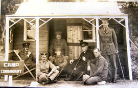
Men on verandah of Camp Commandant Cottage
- AU TAS UTAS ITCCD 2017/18-1a
- Item
- 1915
Black and white photograph of Camp Commandant's hut with men in uniform seated outside, part of the Claremont military camp.

1484 results with digital objects Show results with digital objects
Men on verandah of Camp Commandant Cottage
Black and white photograph of Camp Commandant's hut with men in uniform seated outside, part of the Claremont military camp.
Collection of Cadbury Claremont Images
Black and white photographs of Claremont military camp in about 1915 and the Cadbury chocolate factory and Claremont Golf Club built on the same site, many showing the factory, its surroundings and staff.
Colin Dennison (Curator)
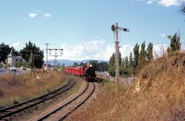
Steam train at Claremont, 1972
Part of Hal Wyatt Collection
Colour photograph of a steam train pulling old style carriage stock leaving Claremont and heading towards Chigwell station.
Hal Wyatt
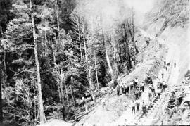
View of railway line under construction, Queenstown Tasmania
Part of Images of West Coast Tasmania
Image has a steam engine and many mining carriages standing beside a steep hillside denuded of vegetation. Many men carrying shovels stand around, apparently working on the site. Image possibly connected to Mt Lyell mining operations.
Photographs of E.Z. Co. Zinc Works at Risdon
The collection features photographs taken by Hobart photographic studio Beattie’s Studio, also known as J.W. Beattie, for the Electrolytic Zinc Co. at the company’s Risdon smelter between 1920 and 1940. The collection depicts construction of new facilities at the factory complex. The first sod was turned on the zinc smeltering plant at Risdon on the western shore of the Derwent River on 16 November 1916, and a test smelter called the 250 lb plant was opened in 1917 to produce 250 lb of zinc a day using the recently developed Roast-Leach-Electrowin (RLE) process of extracting zinc through electrolysis. Electrolytic Zinc’s office occupied the former Derwent Inn. The larger 10-ton plant opened in January 1918 and the 100-ton plant opened in November, 1921. This collection of photographs depicts the phases of construction of the 100-Ton Plant, further expansion of the smelter and decomissioning of some of the older equipment at the zinc works. Beattie’s Studio was a photographic studio founded by Scotsman John Watt Beattie (1859-1930), who began exhibiting photographs soon after his arrival in Tasmania in 1878.
Electrolytic Zinc Company of Australasia Limited
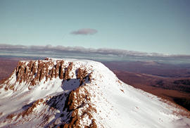
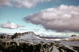
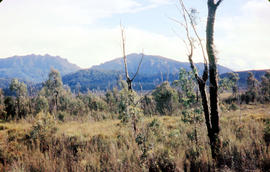
Snow on Mount Olympus from Narcissus hut
Part of Arthur Knight Slides
Colour photograph shows walkers resting in the bush below Mount Olympus
Arthur Knight
Part of Arthur Knight Slides
Colour photograph shows Lake St Clair as viewed from Mount Manfred
Arthur Knight
View of Lake St Clair from Mount Manfred
Part of Arthur Knight Slides
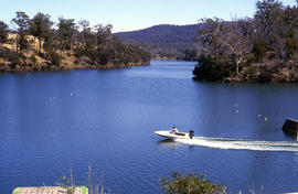
Colour photograph shows motor boat on Lake Trevallyn
Arthur Knight
Part of Arthur Knight Slides
Colour photograph shows snow on Mount Olympus as viewed from near Narcissus hut, near Lake St Clair
Arthur Knight
Walkers rest in bush below Mount Olympus
Part of Arthur Knight Slides
Colour photograph shows snow on Mount Olympus
Arthur Knight
Part of Arthur Knight Slides
Colour photograph shows profile of Mount Olympus
Arthur Knight
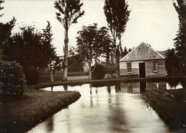
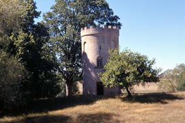
Part of Photographs of Edward Verrell
Photograph showing the first hatchery building built in 1870 at the Salmon Ponds at Plenty surrounded by landscaped grounds filled with exotic trees.
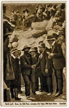
North Lyell - Ryan, the Shift Boss, emerging after being 100 hours below
Part of Images of West Coast Tasmania
Image contains text identifying the subject and also 'copyright'.Originally taken from a postcard published in the weeks following the 1912 North Mount Lyell mine disaster. Image shows people greeting Ryan as he moves towards the photographer, possibly with the mine entrance at the rear.
Colin Dennison (Curator)
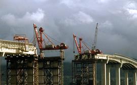
Cranes repairing Tasman Bridge
Part of Hal Wyatt Collection
Colour photograph shows cranes atop pylons at the site of repair work to Tasman Bridge, damaged by the crash of the ore carrier Lake Illawarra in January 1975; missing pylons being replaced.
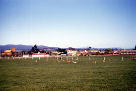
Aerial view of cars choking road near Baskerville race track
Part of Arthur Knight Slides
Colour aerial photograph shows cars travelling to Baskerville Raceway, which opened in 1958
View of lighthouse at Cape Bruny
Part of Arthur Knight Slides
Colour photograph of Bruny Island lighthouse looking south
View of Cape Connella from the air
Part of Arthur Knight Slides
Colour aerial photograph of cliffs of Cape Connella, viewed from the air.
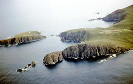
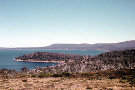
Aerial view of Cape Bruny from south-east
Part of Arthur Knight Slides
Colour photograph of Cape Bruny taken from the air. Photograph depicts coastline of South Bruny Island including lighthouse, Courts Island, Lighthouse Bay
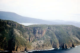
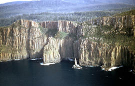
Aerial view of Fluted Cape, South Bruny Island
Part of Arthur Knight Slides
Colour aerial photograph of Fluted Cape, South Bruny Island, 1956
Missing rail section across River Derwent at Macquarie Plains bridge
Part of Arthur Knight Slides
Colour photograph from bank of River Derwent shows twisted railway track
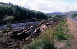
Aftermath of train crash at Woodbury
Part of Arthur Knight Slides
Colour photograph shows aftermath of train crash, with logs and wagons beside track at Woodbury, on a stretch of the government rail line where the track runs parallel with the Midland Highway
Arthur Knight
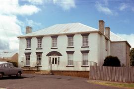
Former Coffee Palace, doctor’s surgery and hotel at Bothwell
Colour photograph of former coffee palace, hotel and doctor’s surgery at 90 Dalrymple Street Bothwell. Citation on National heritage register: “A two storey brick and stucco Georgian building with a stone rear section, licensed as the Young Queen from 1851-1877 when the name was changed to Maskell's Hotel. The building appears in a book on Colonial architecture by Hardy Wilson with a crinolined lady at the doorway with luggage and bird cage. The building is an important townscape element.”
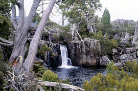
Waterfall on track to Meander Valley Falls
Part of Arthur Knight Slides
Colour photograph shows water spilling into a pool beside track to Meander Falls, with overhanging trees and vegetation surrounding stream
Arthur Knight
Gnarled tree trunk at Liawenee
Part of Arthur Knight Slides
Colour photograph shows gnarled tree trunk at Liawenee
Arthur Knight
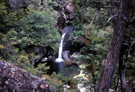
Part of Arthur Knight Slides
Colour photograph shows waterfall flowing across rock face in Central Highlands, with pencil pines surrounding rock pool
Arthur Knight
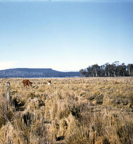
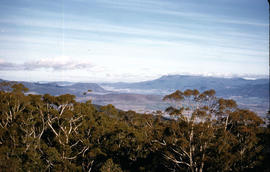
Table Mountain from Interlaken
Part of Arthur Knight Slides
Colour photograph shows cattle grazing in paddock near Interlaken, with flat-topped mountain in the distance
Arthur Knight
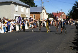
Penny farthing relay at Evandale
Part of Arthur Knight Slides
Colour photograph depicts northern shoreline of Great Lake and settlement of Breona
Arthur Knight
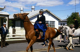
Horse riding at Evandale penny farthing races
Part of Arthur Knight Slides
Colour photographs riders on horseback, including one riding side saddle, at the penny farthing races at Evandale
Arthur Knight
Part of Arthur Knight Slides
Colour photograph shows the Ross War Memorial
Arthur Knight
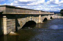
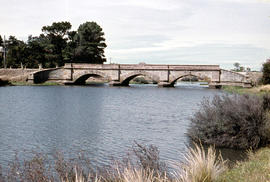
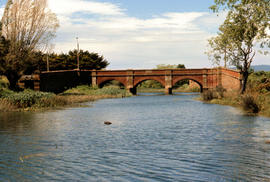
Macquarie River at Ross Bridge
Part of Arthur Knight Slides
Colour photograph shows Ross Bridge across Macquarie River
Arthur Knight
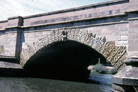
Carvings on Ross Bridge archway
Part of Arthur Knight Slides
Colour photograph shows the sandstone relief carving in the keystone and other carvings in the voussoir stones of an arch of the Ross Bridge across the Macquarie River
Arthur Knight
Part of Arthur Knight Slides
Colour photograph shows the arches of the sandstone bridge at Ross that leads across the Macquarie River
Arthur Knight
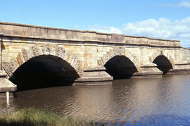
Part of Arthur Knight Slides
Colour photograph shows fast-flowing water of the Macquarie River at the Ross Bridge
Arthur Knight
Poatina Road snakes down Western Tiers
Part of Arthur Knight Slides
Colour photograph shows road snaking down the Western Tiers near Poatina
Arthur Knight
Part of Arthur Knight Slides
Colour photograph shows the Red Bridge, a convict built arch bridge across Elizabeth River at Campbell Town
Arthur Knight
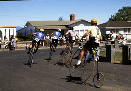
Cyclists sprint on penny farthing bicycles
Part of Arthur Knight Slides
Colour photograph shows cyclists in sprint at penny farthing championships at Evandale
Arthur Knight
Part of Arthur Knight Slides
Colour photograph shows brick birdhouse, or dovecote, on the grounds of Burlington, Cressy
Arthur Knight
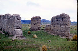
Part of Arthur Knight Slides
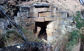
Colour photograph shows ruins of former probation station and convict labour accommodation at Jericho, built with rammed mud walls
Arthur Knight
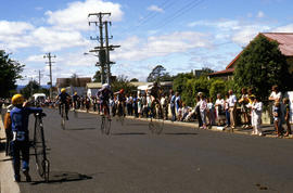
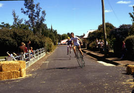
Penny farthing cyclists take a corner
Part of Arthur Knight Slides
Colour photograph shows two cyclists on penny farthing bicycles prepare to take a corner on the course of the penny farthing championships at Evandale, 1984
Arthur Knight
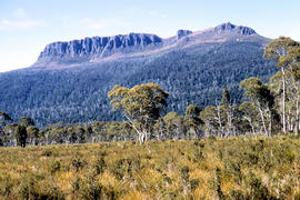
Part of Arthur Knight Slides
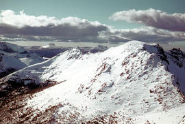
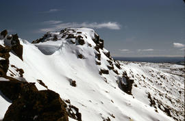
Colour photograph shows snow cover on Mount Ossa
Arthur Knight
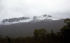
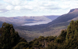
Snow cover on Mount Olympus above Lake St Clair
Part of Arthur Knight Slides
Colour photograph shows snow above the treeline on Mount Olympus
Arthur Knight
Part of Arthur Knight Slides
Colour photograph shows sandstone blocks, one inscribed with the date AD 1837, used in construction of a culvert near Spring Hill
Arthur Knight
Snow on Cradle Mountain and Barn Bluff
Part of Arthur Knight Slides
Colour photograph shows snowfall on Cradle Mountain and Bluff
Arthur Knight
Penny farthing bicycle races at Evandale
Part of Arthur Knight Slides
Colour photograph shows cyclists in heat 4 of the penny farthing championships of 1984 in Evandale
Arthur Knight
Part of Arthur Knight Slides
Colour photograph shows waterhole at Chauncy Vale
Arthur Knight
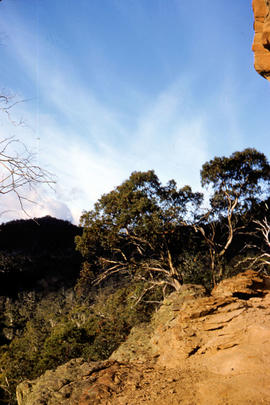
View from cliffs at Chauncy Vale
Part of Arthur Knight Slides
Colour photograph shows cliff and treetops at Chauncy Vale
Arthur Knight
Part of Arthur Knight Slides
Colour photograph shows treeline and valley at Chauncy Vale
Arthur Knight
Part of Arthur Knight Slides
Colour photograph shows man standing high on cliff at Chauncy Vale
Arthur Knight
Part of Arthur Knight Slides
Colour photograph depicts northern shoreline of Great Lake and settlement of Breona
Arthur Knight
Shoreline of Great Lake at Breona
Part of Arthur Knight Slides
Colour photograph depicts northern shoreline of Great Lake and settlement of Breona
Arthur Knight
Paddocks on outskirts of Campbell Town
Part of Arthur Knight Slides
Colour photograph shows sheep in paddocks on outskirts of Campbell Town
Arthur Knight
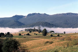
Fog in foothills of Ben Lomond
Part of Arthur Knight Slides
Colour photograph shows fog following the course of a creek in the foothills of Ben Lomond
Arthur Knight
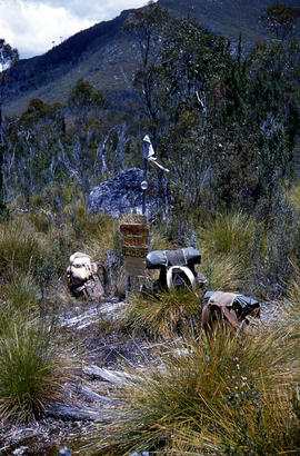
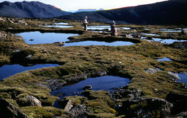
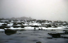
Part of Arthur Knight Slides
Colour photograph shows two people standing upright on the frozen surface of Lake Dobson, 1954
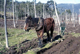
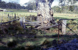
Man and horse ploughing at Westerway
Part of Arthur Knight Slides
Colour photograph shows a farmer ploughing a paddock at Westerway in a field strung with trellis frames for hop cultivation with a draught horse and plough
Part of Arthur Knight Slides
Colour photograph shows rusted International Harvester locomotive on disused rails covered with bracken in a semi-cleared area of land
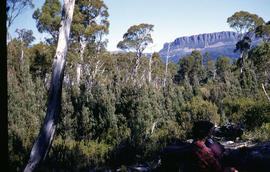
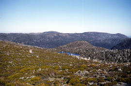
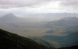
View from Mount Field West across glacial valley
Part of Arthur Knight Slides
Colour photograph shows glacial valley from atop Mount Field West
Part of Arthur Knight Slides
Colour photograph shows view of mountain range to the west of Mount Field West
Part of Arthur Knight Slides
Colour photograph shows bushwalker with backpack wading through Sandfly Creek
View of mountain ranges west of Mt. Lord
Part of Arthur Knight Slides
Colour photograph of mountain ranges west of Mt. Lord
Part of Arthur Knight Slides
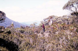
Colour photograph shows man in red and black check bush shirt standing in bush on Mount Lord, looking west. Man is standing amid tall specimens of Pandani, Richea pandanifolia
Part of Arthur Knight Slides
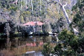
Colour photograph shows the rusting red roofing iron on hut visible above trees on the edge of Twilight Tarn
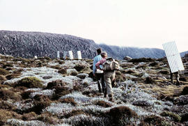
Walkers carrying building materials to K Col
Part of Arthur Knight Slides
Colour photograph shows walkers carrying building materials to build a hut to shelter bushwalkers
Part of Arthur Knight Slides
Colour photograph shows bushwalker with backpack in heath and woodland walking towards the Gordon River
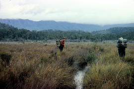
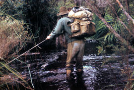
Bushwalking near Sandfly Creek
Part of Arthur Knight Slides
Colour photograph shows two bushwalkers with backpacks near a track to Sandfly Creek
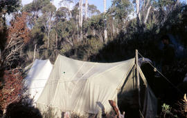
Tents pitched at Mount Bowes campsite
Part of Arthur Knight Slides
Colour photograph shows two canvas tents pitched in hilly scrubland at Mount Bowes
Part of Arthur Knight Slides
Colour photograph shows The Watcher
The Druids near Huon River crossing
Part of Arthur Knight Slides
Colour photograph shows The Druids from near the Huon River crossing
The Druids as viewed from Woody Island
Part of Arthur Knight Slides
Colour photograph shows The Druids as viewed from Woody Island
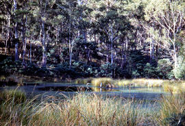
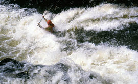
Paddler in the Cruncher at Bradys Lake
Part of Arthur Knight Slides
Colour photograph shows a paddler of a kayak in the Cruncher a segment of water on the Bradys Lake whitewater course
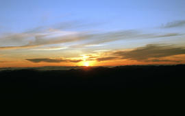
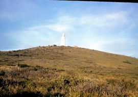
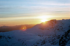
View of sunset from Rodway Range
Part of Arthur Knight Slides
Colour photograph shows sunset as viewed from Rodway Range
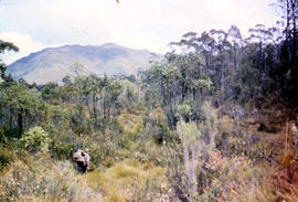
View of heathland near Mount Bowes
Part of Arthur Knight Slides
Colour photograph shows heathland looking southwest from near Mount Bowes
Part of Arthur Knight Slides
Colour photograph shows setting sun from the summit of Mount Field West
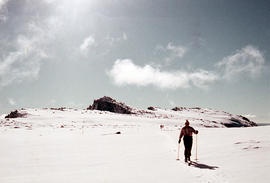
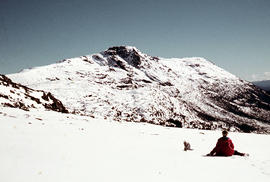
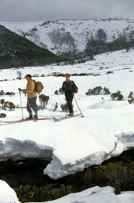
Man skiing downhill on Mount Field West
Part of Arthur Knight Slides
Colour photograph shows man skiing downhill at Mount Field West, with two other figures behind him near the summit of mountain
Marker on South Gordon walking track
Part of Arthur Knight Slides
Colour photograph shows unusual sign for South Gordon walking track turnoff, fashioned out of number plates, with three backpacks resting on ground nearby
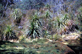
Part of Arthur Knight Slides
Colour photograph shows mossy ground surrounding a group of pandani plants
Four men standing around Skagit loader
Part of Arthur Knight Slides
Colour photograph shows timber workers in hard hats standing around an unladen Skagit loader with an operator visible in the cabin, on a dirt track in the bush
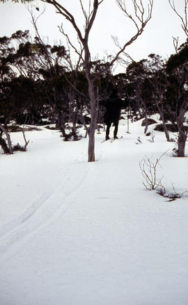
Snow skier plays trick on camera
Part of Arthur Knight Slides
Colour photograph shows the tracks of a snow skier, dressed in dark clothing, going around both sides of a tree on a snow-covered, lightly wooded hill
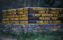
Signs at entrance to Mount Field National Park
Part of Arthur Knight Slides
Colour photograph shows signs posted at entrance of Mount Field National Park, with distances and estimated travel times to Lake Dobson (9 1/4 miles), Lake Fenton (7 1/4 miles), Lady Barron Falls (1 1/2 mile), Camping Ground (250 yds), Rangers Cottage (150 Yds), Russell Falls 1/2 MILE 10 MIN, Lady Barron Falls Round Trip 3 1/2 MILES 1H 45 MIN
Part of Arthur Knight Slides
Colour photograph shows snow covering Tarn Shelf in Mount Field National Park
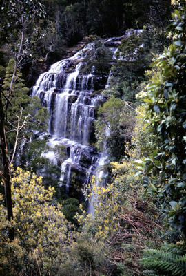
Part of Arthur Knight Slides
Colour photograph shows Russell Falls as viewed from elevated vantage point in rainforest
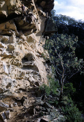
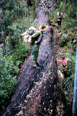
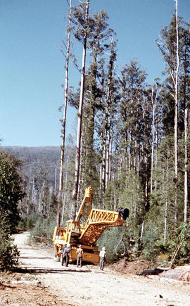
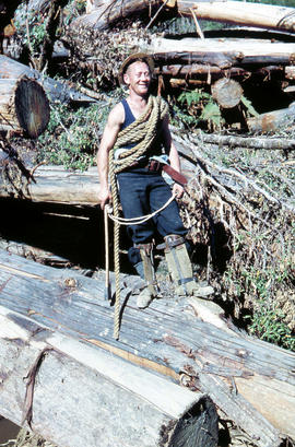
Rigger in the Florentine Valley
Part of Arthur Knight Slides
Colour photograph shows timber worker wearing hard hat, chaps and holding ropes and an axe, standing on fallen logs in the Florentine Valley
Part of Arthur Knight Slides
Colour photograph shows snow cover on the Rodway Range
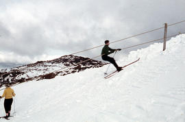
Part of Arthur Knight Slides
Colour photograph shows snow skiers on Mount Mawson, one using a tow rope to climb uphill
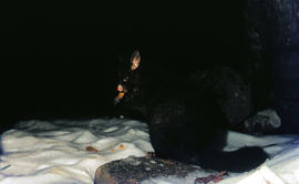
Part of Arthur Knight Slides
Colour photograph shows a possum eating something in the snow at Lake Dobson 1968
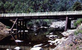
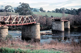
Timber bridge across Plenty River
Part of Arthur Knight Slides
Colour photograph shows the timber frame of the bridge across the Plenty River
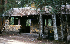
Picnic hut near National Park entrance
Part of Arthur Knight Slides
Colour photograph shows picnic hut near road entrance of Mount Field National Park
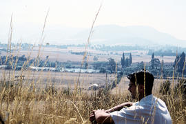
Man sitting in long grass at Plenty
Part of Arthur Knight Slides
Colour photograph shows many with dark hair and spectacles sitting on the edge of cleared farmland at Plenty beside river
Part of Arthur Knight Slides
Colour photograph shows three people resting at Newdegate Pass in Mount Field National Park
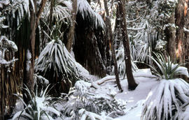
Part of Arthur Knight Slides
Colour photograph shows leaves of Pandani covered by snowfall
Walker sits on snow near Naturalist Peak
Part of Arthur Knight Slides
Colour photograph shows person sitting on the snow near Naturalist Peak
Part of Arthur Knight Slides
Colour photograph shows Lake Newdegate
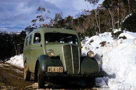
Vehicle on road at National Park
Part of Arthur Knight Slides
Colour photograph shows two-tone green vehicle with driver's fingers visible on steering wheel, on the unsealed road at National Park, with snow covering the higher ground. Tasmanian number plate reads WLA 189 - 19 TAS 56.
Part of Arthur Knight Slides
Colour photograph shows two snow skiiers navigating patchy snow at National Park, a location in Mount Field National Park
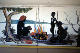
Mural in Hobart Walking Club hut
Part of Arthur Knight Slides
Colour photograph shows a mural in the Hobart Walking Club hut at Lake Dobson Source
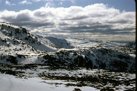
Storm approaches Mount Solitary
Part of Arthur Knight Slides
Colour photograph shows storm approaching Mount Solitary
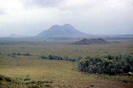
Part of Arthur Knight Slides
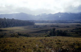
Colour photograph taken from elevated mountain ridge, shows valley floor looking west to Mount Solitary and original shoreline of Lake Pedder
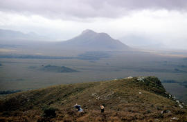
Walkers on ridge overlooking Mount Solitary
Part of Arthur Knight Slides
Colour photograph shows some bushwalkers on a ridge overlooking the valley towards Mount Solitary
Mount Mueller from beyond Damper Inn hut
Part of Arthur Knight Slides
Colour photograph shows lightly timbered woodland near Mount Mueller
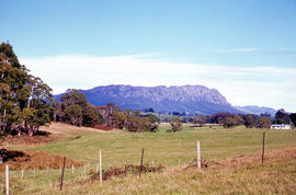
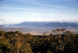
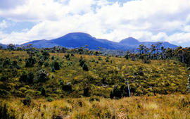
Mount Roland as viewed from paddocks near Sheffield
Part of Arthur Knight Slides
Colour photograph shows Mount Roland, south of Sheffield, with fenced pasture and bush
Ridgeline of Mount Mawson as viewed from Lake Dobson
Part of Arthur Knight Slides
Colour photograph shows snow on the ridgeline of Mount Mawson as viewed from Lake Dobson