Imprimir vista previa Cerrar

Mostrando 1408 resultados

Descripción archivística
Tasmania Imagen Con objetos digitales
Imprimir vista previa Ver :

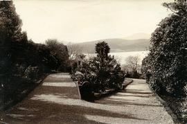
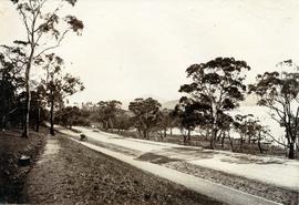
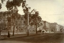
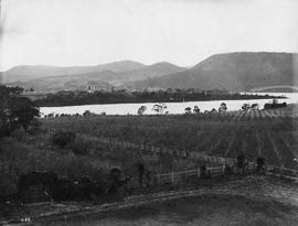
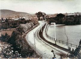
Sandy Bay Road looking towards Hobart

Black-and-white photograph shows Sandy Bay Road, with tram tracks on riverside of road, electric wires for Hobart Electric Tramway, carriage wheelmarks in the unpaved road surface, electricity transmission wires strung from poles mounted with porcelain insulators

Silhouette of Mount Anne

Colour photograph shows afternoon reflection of Mount Anne on the surface of water of Lake Timk

Mount Anne at sunrise

Colour photograph shows Mount Anne at sunrise as viewed from across Lake Timk

Lake Timk and Mount Anne

Colour photograph shows Lake Timk and Mount Anne in distance GIS: Latitude -4293 Longitude 14646 Gazetteer Australia Record_ID TAS16882

Salmon Ponds at Plenty

Photograph showing the first hatchery building built in 1870 at the Salmon Ponds at Plenty surrounded by landscaped grounds filled with exotic trees.

Wreck on beach near Mars Bluff

Colour photograph of rotting timbers from wreck of boat, half-buried in the sand near shallow creek on beach near Mars Bluff, Bruny Island, Photograph possibly taken 1963.

Former Bridge Hotel at Ouse

Colour landscape photograph shows exterior of derelict Bridge Hotel at Ouse, situated in the crook of the Ouse River, a sandstone, weatherboard and tin structure, with windows boarded up

White caps on Lake Myrtle

Colour photograph shows waves and white caps on the surface of Lake Myrtle GIS: Latitude -4188 Longitude 14618 Gazetteer Australia Record_ID TAS02073

Shoreline of Lake Chalice 1979

Colour photograph shows the rocky shoreline of Chalice Lake GIS: Latitude -4188 Longitude 14615 Gazetteer Australia Record_ID TAS02044

Knyvet Falls 1984

Colour photograph of limited water flow across Knyvet Falls 1984 GIS: Latitude -4159 Longitude 14593 Gazetteer Australia Record_ID TAS06008

Buildings on Salamanca Place

Black-and-white photograph shows stone buildings along Salamanca Place, timber stacked on New Wharf and masts of ships docked at the wharf; signs on buildings for “A.E. Lord Wool Merchant” and “W.D. Peacock and Co.”, historic home Lenna and eastern conservatory visible on hilltop behind towards Battery Point; maritime signal station with the Time Ball that was dropped automatically at 1pm, after a relayed telegraph signal from the Melbourne Observatory.

Ford taxi

Ford taxi cab, marked Car 1309, Area 2. Car sporting red plastic nose, possibly in support of Red Nose Day which aims to raise awareness of SIDS

Graeme Raphael

Skiing on Milles Track

Colour photograph of man looking down Mount Wellington, with skis, from Milles Track

Hut at Lake Meston 1977

Colour photograph shows hut at Lake Meston built of logs, shingles and with tin plate chimney People sitting outside hut eating

Photograph of Braeside from the south west

Photograph of Braeside from the South West, Broadmarsh. Taken April 1960. Now known as Stonefield' , 'Braeside' was built in 1824, located at 266 Elderslie Rd, Lower Broadmarsh. A good example of a two storey Georgian home with a separate kitchen wing

Road to Government House, on Gun Carriage Drive

Black-and-white photograph taken looking north along Gun Carriage Drive towards Government House, Hobart, with post-and-rail fences on Derwent River side; a horse harnessed to a four-wheel carriage, is on the left of the road; a small jetty extends from the shoreline and a boat is visible through the trees, anchored just off shore.

Farming area

Black and white photograph taken from hillside, looking down on two-storey house with numerous outbuildings. Fenced paddocks visible.

Graeme Raphael

Flooded Midland Highway 1964

Colour photograph shows Volkswagen combi van being driven through floodwaters across Midland Highway 1964

Skiing shelter

Colour photograph shows two sets of skis and backpacks outside an alpine hut, covered in a snowdrift

Farm house

Photograph of farmhouse in rural setting, Verandah appears to be glassed in on at least two sides/

Graeme Raphael

Photograph of Roydon

Photograph of the front door of Roydon, Broadmarsh. Taken April 1960. Located at 58 Clifton Vale Road, Elderslie. Sandstone farm house with a central door and flanking double hung windows, an attic level and weatherboard addition to the rear. The building has a hipped roof and narrow boxed eaves. The sandstone stables feature a half hipped roof, sandstone walls and an iron roof. The building is a floor and a half and is still in use as a stable. There are some other early buildings on the site.

Cushion plants

Colour photograph shows bed of green cushion plants

Culvert at Foggs Flat

Colour photograph shows a steel-plated culvert beneath a road at Foggs Flat

Close up of Crater Lake

Colour photograph shows shoreline of Crater Lake with sunlit cliffs on opposite bank

Crater Lake

Colour photograph shows Crater Lake

Photograph of Roydon

Photograph of the front door of Roydon, Broadmarsh. Taken April 1960. Located at 58 Clifton Vale Road, Elderslie. Sandstone farm house with a central door and flanking double hung windows, an attic level and weatherboard addition to the rear. The building has a hipped roof and narrow boxed eaves. The sandstone stables feature a half hipped roof, sandstone walls and an iron roof. The building is a floor and a half and is still in use as a stable. There are some other early buildings on the site.

Resultados 601 a 700 de 1408