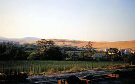
Oast houses and hop fields at Macquarie Plains
- AU TAS UTAS ITCCD 2017/2-170
- Pièce
Fait partie de Arthur Knight Slides
Colour photograph shows hop fields and kilns, or oast houses, at Macquarie Plains, with rail wagons and railway line in foreground
163 résultats avec objets numériques Afficher les résultats avec des objets numériques
Oast houses and hop fields at Macquarie Plains
Fait partie de Arthur Knight Slides
Colour photograph shows hop fields and kilns, or oast houses, at Macquarie Plains, with rail wagons and railway line in foreground
Fait partie de Arthur Knight Slides
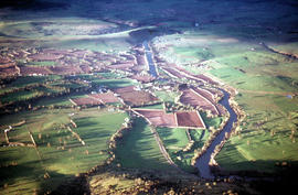
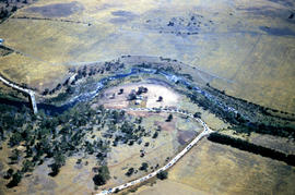
An aerial colour photograph shows distinctive shelter belts around cultivated hop fields alongside River Derwent at Bushy Park, Glenora and Macquarie Plains. Long shadows being cast from the low sun to the west
Gap across River Derwent at Macquarie Plains bridge
Fait partie de Arthur Knight Slides
Colour photograph shows gap in the railway track at Macquarie Plains railway bridge
Fait partie de Arthur Knight Slides
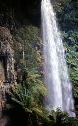
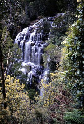
Colour portrait format photograph shows the vertical drop of Marriotts Falls
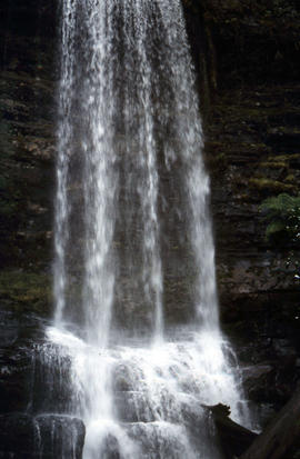
Side view of water flowing over Marriotts Falls
Fait partie de Arthur Knight Slides
Colour portrait format photograph shows side view of the vertical drop of Marriotts Falls
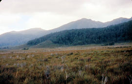
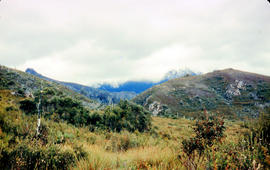
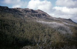
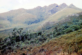
Mount Bowes from Sandfly Creek
Fait partie de Arthur Knight Slides
Colour photograph shows Mount Bowes as viewed from Sandfly Creek
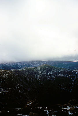
Fait partie de Arthur Knight Slides
Colour portrait format photograph shows low cloud over Mount Bridges, with patches of snow on the ground
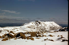
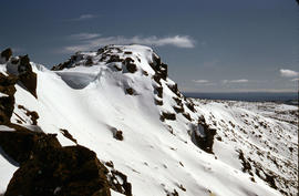
Mount Field West under snow as viewed from Rodway Range
Fait partie de Arthur Knight Slides
Colour photograph from bank of River Derwent shows twisted railway track
Mount Eliza covered in low cloud
Fait partie de Arthur Knight Slides
Colour photograph shows lightly timbered heath and woodland and Mount Eliza in the background covered in low cloud

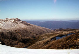
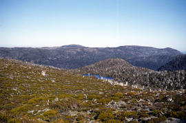
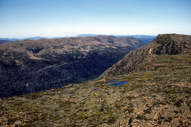
Mount Field West from Rodway Range
Fait partie de Arthur Knight Slides
Colour photograph shows Mount Field West from the Rodway Range
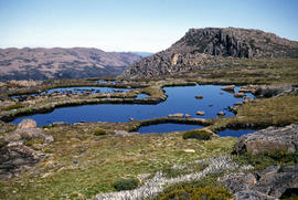
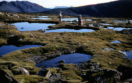
Fait partie de Arthur Knight Slides
Colour photograph shows small tarns on alpine plateau at Mount Field West
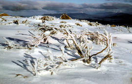
Ice-covered shrubs on Mount Mawson
Fait partie de Arthur Knight Slides
Colour photograph shows ice formation on branches of shrub at Mount Mawson
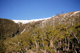
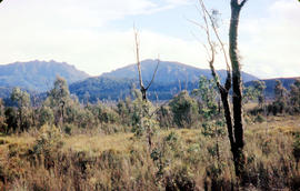
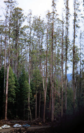
Trees on slope of Mount Mawson
Fait partie de Arthur Knight Slides
Colour photograph shows mature forest, amid some patches of dead tree cover, on steep slope at base of Mount Mawson
View of Mount Mawson from Florentine Peak saddle
Fait partie de Arthur Knight Slides
Colour photograph shows Mount Mawson viewed from saddle of Florentine Peak, with partial snow cover
Ridgeline of Mount Mawson as viewed from Lake Dobson
Fait partie de Arthur Knight Slides
Colour photograph shows snow on the ridgeline of Mount Mawson as viewed from Lake Dobson
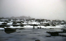
Low visibility on Mount Mawson plateau
Fait partie de Arthur Knight Slides
Colour photograph shows ice and snow amid rocky outcrops on Mount Mawson plateau
Mount Mueller from beyond Damper Inn hut
Fait partie de Arthur Knight Slides
Colour photograph shows lightly timbered woodland near Mount Mueller
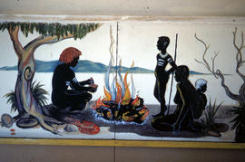
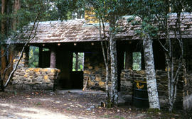
Mural in Hobart Walking Club hut
Fait partie de Arthur Knight Slides
Colour photograph shows a mural in the Hobart Walking Club hut at Lake Dobson Source
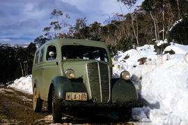
Vehicle on road at National Park
Fait partie de Arthur Knight Slides
Colour photograph shows two-tone green vehicle with driver's fingers visible on steering wheel, on the unsealed road at National Park, with snow covering the higher ground. Tasmanian number plate reads WLA 189 - 19 TAS 56.
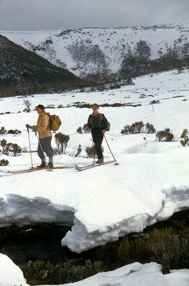
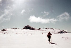
Fait partie de Arthur Knight Slides
Colour photograph shows two snow skiiers navigating patchy snow at National Park, a location in Mount Field National Park
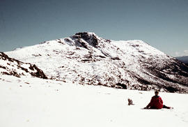
Walker sits on snow near Naturalist Peak
Fait partie de Arthur Knight Slides
Colour photograph shows person sitting on the snow near Naturalist Peak
Fait partie de Arthur Knight Slides
Colour photograph shows Lake Newdegate
Fait partie de Arthur Knight Slides
Colour photograph shows three people resting at Newdegate Pass in Mount Field National Park
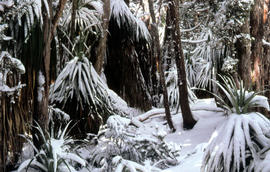
Fait partie de Arthur Knight Slides
Colour photograph shows leaves of Pandani covered by snowfall
Picnic hut near National Park entrance
Fait partie de Arthur Knight Slides
Colour photograph shows picnic hut near road entrance of Mount Field National Park
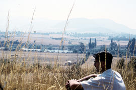
Man sitting in long grass at Plenty
Fait partie de Arthur Knight Slides
Colour photograph shows many with dark hair and spectacles sitting on the edge of cleared farmland at Plenty beside river
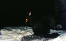
Fait partie de Arthur Knight Slides
Colour photograph shows a possum eating something in the snow at Lake Dobson 1968
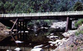
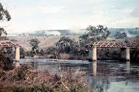
Timber bridge across Plenty River
Fait partie de Arthur Knight Slides
Colour photograph shows the timber frame of the bridge across the Plenty River
Fait partie de Arthur Knight Slides
Colour photograph shows snow skiers on Mount Mawson, one using a tow rope to climb uphill
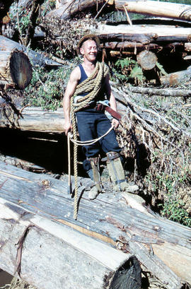
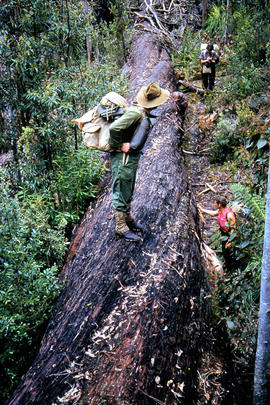
Rigger in the Florentine Valley
Fait partie de Arthur Knight Slides
Colour photograph shows timber worker wearing hard hat, chaps and holding ropes and an axe, standing on fallen logs in the Florentine Valley
Fait partie de Arthur Knight Slides
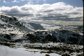
Colour photograph shows snow cover on the Rodway Range
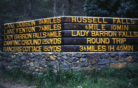
Signs at entrance to Mount Field National Park
Fait partie de Arthur Knight Slides
Colour photograph shows signs posted at entrance of Mount Field National Park, with distances and estimated travel times to Lake Dobson (9 1/4 miles), Lake Fenton (7 1/4 miles), Lady Barron Falls (1 1/2 mile), Camping Ground (250 yds), Rangers Cottage (150 Yds), Russell Falls 1/2 MILE 10 MIN, Lady Barron Falls Round Trip 3 1/2 MILES 1H 45 MIN
Fait partie de Arthur Knight Slides
Colour photograph shows snow covering Tarn Shelf in Mount Field National Park
Fait partie de Arthur Knight Slides
Colour photograph shows Russell Falls as viewed from elevated vantage point in rainforest
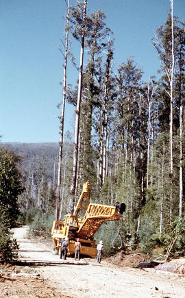
Four men standing around Skagit loader
Fait partie de Arthur Knight Slides
Colour photograph shows timber workers in hard hats standing around an unladen Skagit loader with an operator visible in the cabin, on a dirt track in the bush
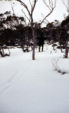
Snow skier plays trick on camera
Fait partie de Arthur Knight Slides
Colour photograph shows the tracks of a snow skier, dressed in dark clothing, going around both sides of a tree on a snow-covered, lightly wooded hill
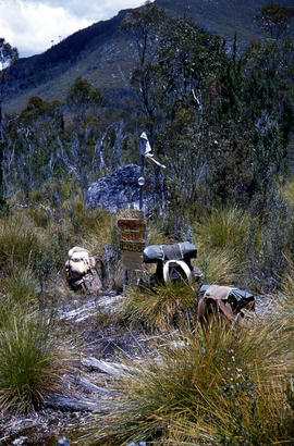
Marker on South Gordon walking track
Fait partie de Arthur Knight Slides
Colour photograph shows unusual sign for South Gordon walking track turnoff, fashioned out of number plates, with three backpacks resting on ground nearby
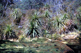
Fait partie de Arthur Knight Slides
Colour photograph shows mossy ground surrounding a group of pandani plants
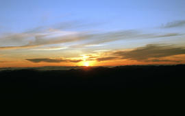
Fait partie de Arthur Knight Slides
Colour photograph shows setting sun from the summit of Mount Field West
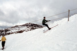
Man skiing downhill on Mount Field West
Fait partie de Arthur Knight Slides
Colour photograph shows man skiing downhill at Mount Field West, with two other figures behind him near the summit of mountain
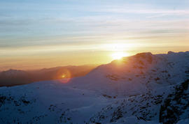
View of sunset from Rodway Range
Fait partie de Arthur Knight Slides
Colour photograph shows sunset as viewed from Rodway Range
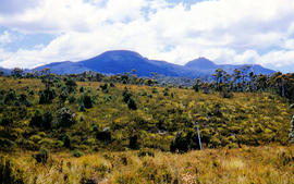
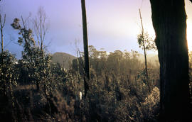
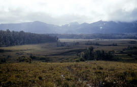
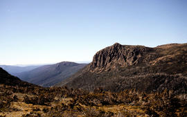
View of heathland near Mount Bowes
Fait partie de Arthur Knight Slides
Colour photograph shows heathland looking southwest from near Mount Bowes
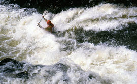
Paddler in the Cruncher at Bradys Lake
Fait partie de Arthur Knight Slides
Colour photograph shows a paddler of a kayak in the Cruncher a segment of water on the Bradys Lake whitewater course
The Druids near Huon River crossing
Fait partie de Arthur Knight Slides
Colour photograph shows The Druids from near the Huon River crossing
The Druids as viewed from Woody Island
Fait partie de Arthur Knight Slides
Colour photograph shows The Druids as viewed from Woody Island
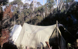
Tents pitched at Mount Bowes campsite
Fait partie de Arthur Knight Slides
Colour photograph shows two canvas tents pitched in hilly scrubland at Mount Bowes
Fait partie de Arthur Knight Slides
Colour photograph shows The Watcher
Fait partie de Arthur Knight Slides
Colour photograph shows bushwalker with backpack in heath and woodland walking towards the Gordon River
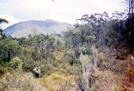
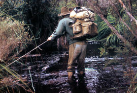
Bushwalking near Sandfly Creek
Fait partie de Arthur Knight Slides
Colour photograph shows two bushwalkers with backpacks near a track to Sandfly Creek
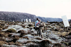
Walkers carrying building materials to K Col
Fait partie de Arthur Knight Slides
Colour photograph shows walkers carrying building materials to build a hut to shelter bushwalkers
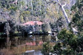
Fait partie de Arthur Knight Slides
Colour photograph shows the rusting red roofing iron on hut visible above trees on the edge of Twilight Tarn
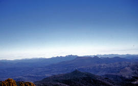
View of mountain ranges west of Mt. Lord
Fait partie de Arthur Knight Slides
Colour photograph of mountain ranges west of Mt. Lord
Fait partie de Arthur Knight Slides
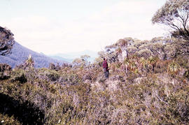
Colour photograph shows man in red and black check bush shirt standing in bush on Mount Lord, looking west. Man is standing amid tall specimens of Pandani, Richea pandanifolia
Fait partie de Arthur Knight Slides
Colour photograph shows bushwalker with backpack wading through Sandfly Creek
View from Mount Field West across glacial valley
Fait partie de Arthur Knight Slides
Colour photograph shows glacial valley from atop Mount Field West
Fait partie de Arthur Knight Slides
Colour photograph shows view of mountain range to the west of Mount Field West
Fait partie de Arthur Knight Slides
Colour photograph shows rusted International Harvester locomotive on disused rails covered with bracken in a semi-cleared area of land
Fait partie de Arthur Knight Slides
Colour photograph shows two people standing upright on the frozen surface of Lake Dobson, 1954
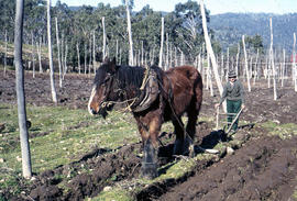
Man and horse ploughing at Westerway
Fait partie de Arthur Knight Slides
Colour photograph shows a farmer ploughing a paddock at Westerway in a field strung with trellis frames for hop cultivation with a draught horse and plough
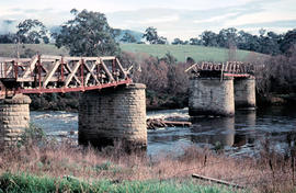
Missing rail section across River Derwent at Macquarie Plains bridge
Fait partie de Arthur Knight Slides
Colour photograph from bank of River Derwent shows twisted railway track
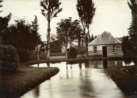
Fait partie de Photographs of Edward Verrell
Photograph showing the first hatchery building built in 1870 at the Salmon Ponds at Plenty surrounded by landscaped grounds filled with exotic trees.
Fait partie de De La Haye Postcard Collection
One hand coloured panorama image, captioned & numbered 23 , in proprietary envelope showing a panorama of New Norfolk.
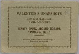
From envelope - Valentine's Snapshots. Eight real photographs. Hand coloured. Beauty spots around Hobart, Tasmania No.3. Published by the Valentine Publishing Co., Melbourne and Sydney.
Valentine Publishing

Fait partie de De La Haye Postcard Collection
Ten captioned fold out colour images in proprietary post-able envelope. Showing views of Hobart and New Norfolk.
From envelope : A Colorful Souvenir of New Norfolk, Tas. Derwent Valley with Hobart. Up-to-Date Views. G & G Series.
Fait partie de George Musgrave Parker : Correspondence and research records
Sketch thought to be by Douglas Pratt
George Musgrave Parker
Fait partie de George Musgrave Parker : Correspondence and research records
Sketch by Roy Cox
George Musgrave Parker