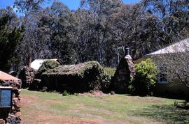
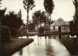
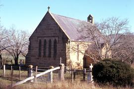
Affichage de 1187 résultats

Description archivistique
Images of Tasmania as collected by Colin Dennison : University of Tasmania Library Special & Rare Collections Tasmania Avec objets numériques
Aperçu avant impression Affichage :

View of Dunkleys Point at Sandy Bay

Black-and-white photograph shows Sandy Bay Road in foreground, the grand home St Helena on what is known as Dunkleys Point, and Battery Point on the opposite shore of the bay

Road to Government House, on Gun Carriage Drive

Black-and-white photograph taken looking north along Gun Carriage Drive towards Government House, Hobart, with post-and-rail fences on Derwent River side; a horse harnessed to a four-wheel carriage, is on the left of the road; a small jetty extends from the shoreline and a boat is visible through the trees, anchored just off shore.

Salmon Ponds at Plenty

Photograph showing the first hatchery building built in 1870 at the Salmon Ponds at Plenty surrounded by landscaped grounds filled with exotic trees.

Adamsons Peak from Cloudy Bay

Colour photograph taken from beach at Cloudy Bay on Bruny Island, looking west to Adamsons Peak on Tasmanian mainland

Trees reflected in Artists Pool

Colour photograph of Artists Pool, a waterhole near Cradle Mountain, with reflections of alpine plants on the water's surface

Pointing out a dead bird

Colour photograph shows a person pointing at a dead bird on the ground near Bare Mountain, with new undergrowth shooting after a recent bushfire and several bushwalkers visible in the distance

Walkers near Barn Bluff

Colour photograph of two walkers trying to avoid slippery pathway with flecks of snow on ground and Barn Bluff in background

Knyvet Falls 1984

Colour photograph of limited water flow across Knyvet Falls 1984 GIS: Latitude -4159 Longitude 14593 Gazetteer Australia Record_ID TAS06008

Shoreline of Lake Chalice 1979

Colour photograph shows the rocky shoreline of Chalice Lake GIS: Latitude -4188 Longitude 14615 Gazetteer Australia Record_ID TAS02044

Lake Timk and Mount Anne

Colour photograph shows Lake Timk and Mount Anne in distance GIS: Latitude -4293 Longitude 14646 Gazetteer Australia Record_ID TAS16882

Mount Rogoona

Colour photograph shows Mount Rogoona with Lake Myrtle obscured by light alpine forest vegetation on ridge

Kayaker below Repulse Dam

Colour photograph shows a kayaker falling into the Derwent River, below the site of the Repulse Dam, in 1964

Interview with Colin Dennison

  • Collection
  • 2018

Interview with Colin Dennison dated 25th August 2018. Interview conducted by Ben Ross (www.oralhistorycompany.com) concerning Colin’s lifetime of collecting photographs, postcards, stamps and other historical resources. Colin donated the collection to the University of Tasmania Library Special & Rare Collections.

Ben Ross

Résultats 1101 à 1187 sur 1187