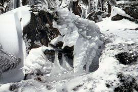
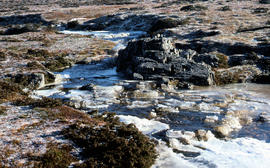
Ice formation on rocks at Ben Lomond 1962
- AU TAS UTAS ITCCD 2017/2-287
- Unidad documental simple
- 1962
Parte deArthur Knight Slides
Colour photograph shows ice formation on rocks atop Ben Lomond 1962
Ice formation on rocks at Ben Lomond 1962
Parte deArthur Knight Slides
Colour photograph shows ice formation on rocks atop Ben Lomond 1962

Snowfall at Jaffa Vale and Mount Olympus
Parte deArthur Knight Slides
Colour photograph shows tracks of snow skiers at Jaffa Vale and Mount Olympus

Parte deArthur Knight Slides
Colour photograph of limited water flow across Knyvet Falls 1984 GIS: Latitude -4159 Longitude 14593 Gazetteer Australia Record_ID TAS06008

Shoreline of Lake Chalice 1979
Parte deArthur Knight Slides
Colour photograph shows the rocky shoreline of Chalice Lake GIS: Latitude -4188 Longitude 14615 Gazetteer Australia Record_ID TAS02044
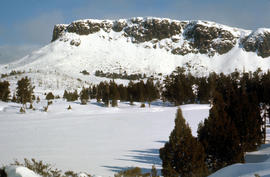
Lees Paddock and Mount Pillinger
Parte deArthur Knight Slides
Colour photograph shows the cleared land of Lees Paddocks in the upper Mersey Valley, surrounded by bush with Mount Pillinger in the background
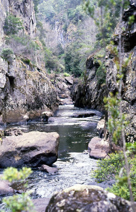
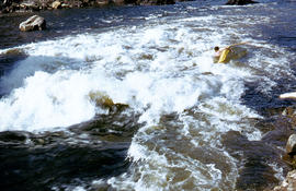
Portrait format photograph of Leven Canyon
Parte deArthur Knight Slides
Colour portrait format photograph shows Leven River spilling in to narrow gorge in the part of the river known as Leven Canyon
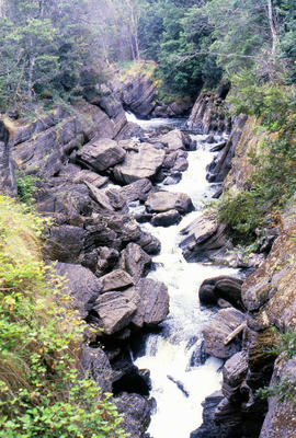
Parte deArthur Knight Slides
Colour photograph shows whitewater in narrow section of Leven Canyon
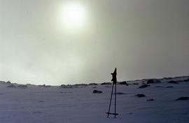
Morning mist on Ben Lomond 1962
Parte deArthur Knight Slides
Colour photograph shows pair of gloves on a set of ski poles pitched into snow atop Ben Lomond, with mist covering the sun
Cliffs of Mount Anne above Lake Timk
Parte deArthur Knight Slides
Colour photograph shows the cliffs of Mount Anne above Lake Timk

Parte deArthur Knight Slides
Colour photograph shows Lake Timk and Mount Anne in distance GIS: Latitude -4293 Longitude 14646 Gazetteer Australia Record_ID TAS16882

Reflection of Mount Anne on surface of Lake Timk
Parte deArthur Knight Slides
Colour portrait format photograph shows reflection of Mount Anne on the surface of Lake Timk

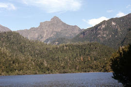
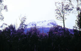
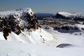
Mount Ossa and Cathedral Mountain
Parte deArthur Knight Slides
Colour photograph shows rocky peak of Mount Rogoona, with alpine plain in foreground

Parte deArthur Knight Slides
Colour photograph shows Mount Rogoona with Lake Myrtle obscured by light alpine forest vegetation on ridge

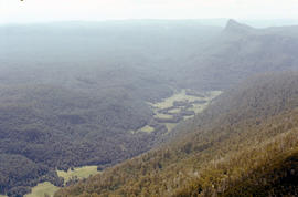
Panoramic view of Mount Rogoona
Parte deArthur Knight Slides
Colour photograph shows farmland in the Kentish area with Mount Roland in background

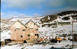
View across Cradle Mountain ridges to the north
Parte deArthur Knight Slides
Colour photograph shows people standing outside Northern Tasmanian Alpine Club hut at Ben Lomond, one holding snow skis and poles
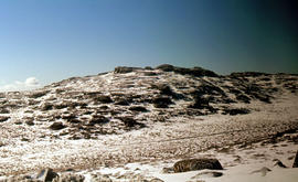
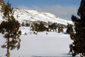
Piesse Vale on Ben Lomond plateau
Parte deArthur Knight Slides
Colour photograph shows plateau near Cradle Mountain
Creek on plateau above Cradle Mountain
Parte deArthur Knight Slides
Colour photograph shows plateau near summit of Ben Lomond
Pool of Siloam & The Temple 1978
Parte deArthur Knight Slides
Colour photograph shows snow covering Pool of Siloam near the West Wall of Mount Jerusalem
Pool of Siloam and the West Wall of Mount Jerusalem
Parte deArthur Knight Slides
Colour photograph shows dolerite peak of Ragged Jack, near Ben Lomond, viewed across from lightly timbered farmland
Parte deArthur Knight Slides
Colour photograph shows ski runs near summit of Ben Lomond 1960
Parte deArthur Knight Slides
Colour photograph of Strickland Valley near Ben Lomond, with partial snow cover, 1960
Parte deArthur Knight Slides
Colour photograph shows heavy snow cover on forest at West Wall near Mount Jerusalem
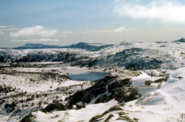
Western Bluff & Lake Thor 1978
Parte deArthur Knight Slides
Colour photograph shows view west from Back Mountain 1983
Parte deArthur Knight Slides
Colour photograph shows a kayaker falling into the Derwent River, below the site of the Repulse Dam, in 1964
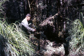
Parte deArthur Knight Slides
Colour photograph shows man repairing boots in shade of forest
Parte deArthur Knight Slides
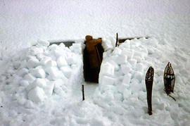
Colour photograph shows a snow cave excavation
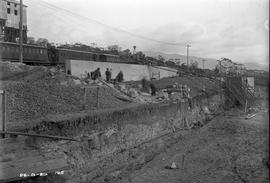
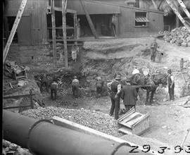
Excavation and construction below railway line at Risdon
Black-and-white photograph shows excavation and construction of retaining walls at E.Z. Co. Zinc Works at Risdon below the level of the railway line
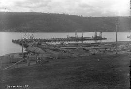
Construction of new Risdon wharf
Black-and-white photograph shows construction of wharf at E.Z. Co. Zinc Works at Risdon
Cladding a building at E.Z. zinc works
Black-and-white photograph depicts workers fixing corrugated iron sheets to exterior wall of a new building at E.Z. Co. Zinc Works at Risdon
Construction of retaining wall at E.Z. Co Zinc Works
Black-and-white photograph depicts workers building a retaining wall at E.Z. Co. Zinc Works at Risdon
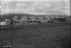
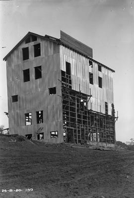
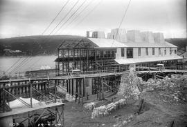
Exterior view of cell room at E.Z. Co. Zinc Works 100-ton plant
Black-and-white photograph shows exterior of newly constructed cell room at E.Z. Co. Zinc Works at Risdon viewed from the south, looking downhill to the Derwent River.
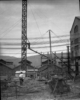
Concrete pouring tower hoisted at E.Z. Co. Zinc Works
Black-and-white photograph shows concrete pouring tower, held in position with stays during expansion of power house at E.Z. Co. Zinc Works at Risdon

Workers assembling jacket of Derwent Prime furnace at E.Z. Co. Zinc Works
Black-and-white photograph shows men assembling sides and ends of jacket of Derwent Prime furnace at E.Z. Co. Zinc Works at Risdon
Staging for Derwent Prime furnace jacket at E.Z. Co. Zinc Works
Black-and-white photograph shows men building staging for Derwent Prime furnace at E.Z. Co. Zinc Works at Risdon
Excavation for Derwent Prime furnace at E.Z. Co. Zinc Works
Black-and-white photograph shows workmen digging earth and rubble to be loaded into a horse-drawn cart at excavation site for new Derwent Prime furnace being built at E.Z Co. Zinc Works 1930
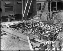
Framework for pouring concrete in the power station building at E.Z. Co. Zinc Works
Black-and-white photograph shows workmen sitting down and horse eating from nosebag in front of timber framework for concrete pour for construction of power station building at E.Z. Co. Zinc Works at Risdon 1921
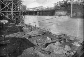
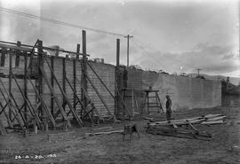
Construction of retaining wall below train line at E.Z. Co Zinc Works
Black-and-white photograph shows construction of a retaining wall below the level of the train line for a new building as part of the roasting and leaching divisions of the 100-Ton Plant, at E.Z. Co. Zinc Works
View downhill to River Derwent from E.Z. Co. Zinc Works 100-Ton Plant construction site
Black-and-white photograph shows view dowhill to River Derwent looking across construction site of E.Z. Co. Zinc Works construction site of 100-Ton Plant
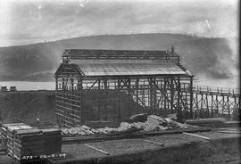
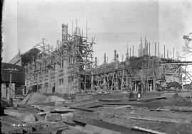
Workers building framework of new building at E.Z. Co Zinc Works 1924
Black-and-white photograph shows piles of sawn timber, scaffolding and workers constructing the framework of a new building on an elevated site at the E.Z. Co. Zinc Works 1924
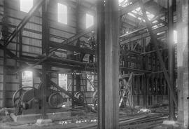
Workers pause for photo inside new building at E.Z. Co Zinc Works 1924
Black-and-white photograph shows construction workers pausing for a photograph inside a new building at E.Z. Co. Zinc Works at Risdon 1924
Parte deDennison Collection
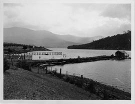
Photograph of Geilston Bay looking toward Mt Wellington showing jetty and breakwater
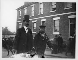
Photograph of Japanese sailors
Parte deDennison Collection
Photograph of Japanese sailor and Japanese gentleman walking in front of Portsea Terrace, Montpelier Retreat, Battery Point.
Parte deDennison Collection
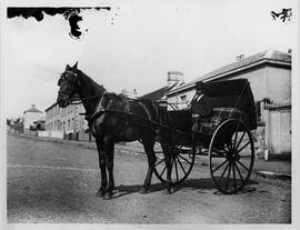
Photograph of a man in a bowler hat sitting in a two wheeled horse drawn gig in the street
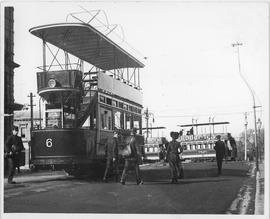
Photograph of double decker electric tram
Parte deDennison Collection
Photograph of a double decker tram in Elizabeth Street Hobart. Other double decker trams in Macquarie Street c.1893
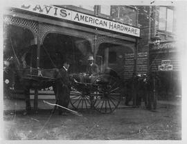
Photograph of carriage outside Charles Davis store, Hobart
Parte deDennison Collection
Photograph of men and a horse drawn cart outside Charles Davis store Hobart. c1887
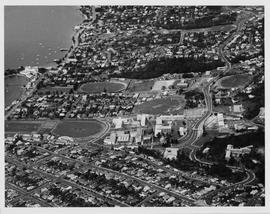
Aerial view of UTAS Sandy Bay Campus
Parte deDennison Collection
Aerial view of the Sandy Bay Campus of the University of Tasmania. Showing sporting fields, Hutchins School, surrounding houses and Wrest Point Hotel prior to the construction of the casino
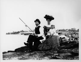
Photograph of family group fishing
Parte deDennison Collection
Photograph of a man, woman and small child sitting on the rocks fishing. Thought to be Beltana now Lindisfarne with jetty in background.
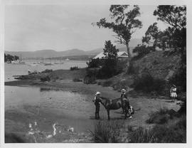
Children and pony on the beach
Parte deDennison Collection
Photograph of children and pony on the beach at a small cove on the eastern shore of the Derwent River.