- AU TAS UTAS ITCCD 2017/2-204
- Item
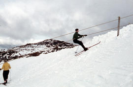
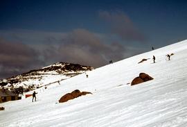
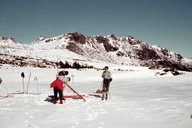
Part of Arthur Knight Slides
Colour photograph shows snow skiers on Mount Mawson, one using a tow rope to climb uphill
163 results with digital objects Show results with digital objects
Part of Arthur Knight Slides
Colour photograph shows snow skiers on Mount Mawson, one using a tow rope to climb uphill
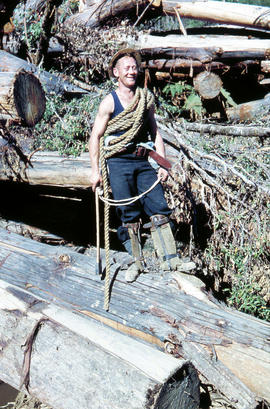
Rigger in the Florentine Valley
Part of Arthur Knight Slides
Colour photograph shows timber worker wearing hard hat, chaps and holding ropes and an axe, standing on fallen logs in the Florentine Valley
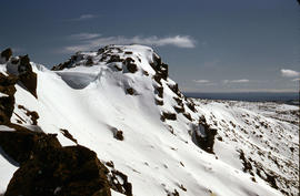
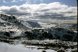
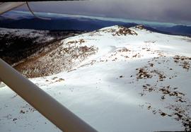
Part of Arthur Knight Slides
Colour photograph shows snow cover on the Rodway Range
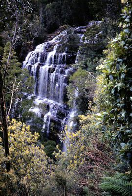
Part of Arthur Knight Slides
Colour photograph shows Russell Falls as viewed from elevated vantage point in rainforest
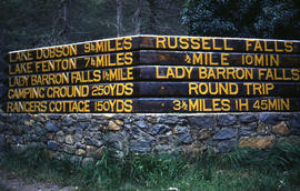
Signs at entrance to Mount Field National Park
Part of Arthur Knight Slides
Colour photograph shows signs posted at entrance of Mount Field National Park, with distances and estimated travel times to Lake Dobson (9 1/4 miles), Lake Fenton (7 1/4 miles), Lady Barron Falls (1 1/2 mile), Camping Ground (250 yds), Rangers Cottage (150 Yds), Russell Falls 1/2 MILE 10 MIN, Lady Barron Falls Round Trip 3 1/2 MILES 1H 45 MIN
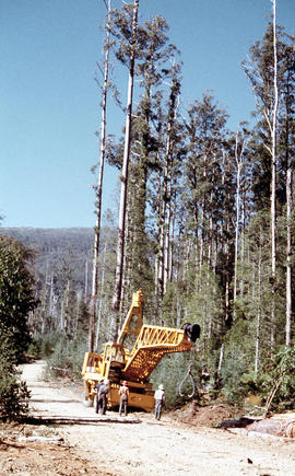
Four men standing around Skagit loader
Part of Arthur Knight Slides
Colour photograph shows timber workers in hard hats standing around an unladen Skagit loader with an operator visible in the cabin, on a dirt track in the bush
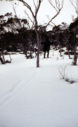
Snow skier plays trick on camera
Part of Arthur Knight Slides
Colour photograph shows the tracks of a snow skier, dressed in dark clothing, going around both sides of a tree on a snow-covered, lightly wooded hill
Marker on South Gordon walking track
Part of Arthur Knight Slides
Colour photograph shows unusual sign for South Gordon walking track turnoff, fashioned out of number plates, with three backpacks resting on ground nearby
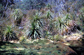
Part of Arthur Knight Slides
Colour photograph shows mossy ground surrounding a group of pandani plants
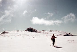
Man skiing downhill on Mount Field West
Part of Arthur Knight Slides
Colour photograph shows man skiing downhill at Mount Field West, with two other figures behind him near the summit of mountain
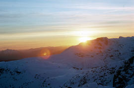
Part of Arthur Knight Slides
Colour photograph shows setting sun from the summit of Mount Field West
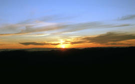
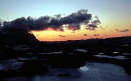
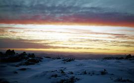
View of sunset from Rodway Range
Part of Arthur Knight Slides
Colour photograph shows sunset as viewed from Rodway Range
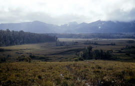
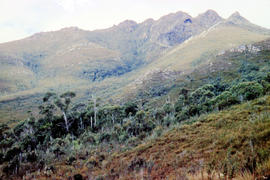
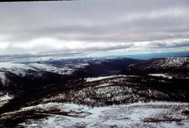
View of heathland near Mount Bowes
Part of Arthur Knight Slides
Colour photograph shows heathland looking southwest from near Mount Bowes
Part of Arthur Knight Slides
Colour photograph shows snow covering Tarn Shelf in Mount Field National Park
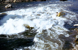
Paddler in the Cruncher at Bradys Lake
Part of Arthur Knight Slides
Colour photograph shows a paddler of a kayak in the Cruncher a segment of water on the Bradys Lake whitewater course
The Druids as viewed from Woody Island
Part of Arthur Knight Slides
Colour photograph shows The Druids as viewed from Woody Island
The Druids near Huon River crossing
Part of Arthur Knight Slides
Colour photograph shows The Druids from near the Huon River crossing
Part of Arthur Knight Slides
Colour photograph shows The Watcher
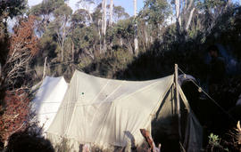
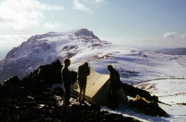
Tents pitched at Mount Bowes campsite
Part of Arthur Knight Slides
Colour photograph shows two canvas tents pitched in hilly scrubland at Mount Bowes
Part of Arthur Knight Slides
Colour photograph shows bushwalker with backpack in heath and woodland walking towards the Gordon River
Bushwalking near Sandfly Creek
Part of Arthur Knight Slides
Colour photograph shows two bushwalkers with backpacks near a track to Sandfly Creek
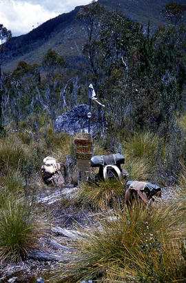
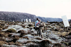
Walkers carrying building materials to K Col
Part of Arthur Knight Slides
Colour photograph shows walkers carrying building materials to build a hut to shelter bushwalkers
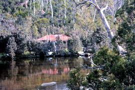
Part of Arthur Knight Slides
Colour photograph shows the rusting red roofing iron on hut visible above trees on the edge of Twilight Tarn
Part of Arthur Knight Slides
Colour photograph shows man in red and black check bush shirt standing in bush on Mount Lord, looking west. Man is standing amid tall specimens of Pandani, Richea pandanifolia
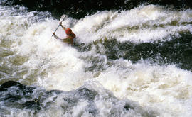
Part of Arthur Knight Slides
Colour photograph shows a kayaker falling into the Derwent River, below the site of the Repulse Dam, in 1964
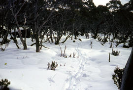
Track to Lakes Belton and Bercher under snow
Part of Arthur Knight Slides
Colour photograph shows footsteps in the snow on the track to Lake Belton and Lake Belcher
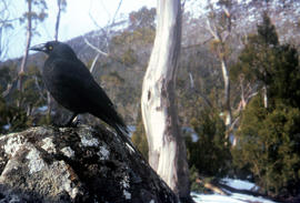
Part of Arthur Knight Slides
Colour photograph shows a black jay, or black currawong, resting on a rock near Lake Dobson
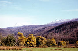
Blossom and snow at Fitzgerald
Part of Arthur Knight Slides
Colour photograph shows yellow blossoms on a stand of wattle trees in foreground and snow on hills behind, at Fitzgerald, near Maydena
Part of Hal Wyatt Collection
Colour aerial photograph shows snow on Florentine Peak and Mount Field West
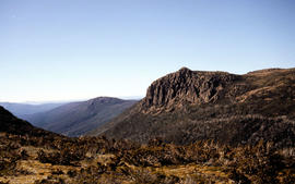
Florentine Peak from Mawson Plateau
Part of Hal Wyatt Collection
Colour photograph shows Florentine Peak from Mawson Plateau, 1968.
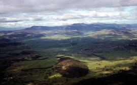
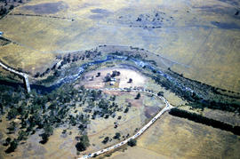
Aerial view of farmland at Glenora
Part of Hal Wyatt Collection
Colour aerial photograph of farmland at Glenora
Golden Stairs ski run at Mount Mawson
Part of Hal Wyatt Collection
Colour photograph of snow on the Golden Stairs, a ski run near Mount Field
Part of Hal Wyatt Collection
Colour aerial photograph of Golden Stairs on Mount Mawson

Heavy snowfall at Hobart Walking Club hut at Lake Dobson
Part of Hal Wyatt Collection
Colour photograph shows smoke curling from the chimney of the Hobart Walking Club hut at Lake Dobson after heavy snowfall
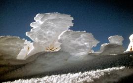
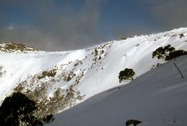
Ice on bushes at Newdegate Pass
Part of Hal Wyatt Collection
Colour photograph of ice on bushes at Newdegate Pass, 1970
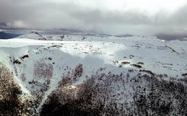
Aerial view of Mount Field West and Mount Mueller
Part of Hal Wyatt Collection
Colour aerial photograph of Mount Field West and Mount Mueller 1970
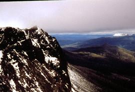
View of Mount Field West from Florentine Peak
Part of Hal Wyatt Collection
Colour photograph of Mount Field West from Florentine Peak 1966
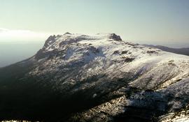
Aerial view of Mount Mawson 1970
Part of Hal Wyatt Collection
Colour aerial photograph of Mount Mawson under snow cover

Part of Hal Wyatt Collection
Colour photograph of people skiing at Mount Mawson
Skiers on Mount Mawson plateau
Part of Hal Wyatt Collection
Colour aerial photograph of Mount Mawson ski field with skiers visible
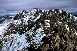
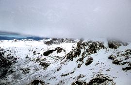
Aerial view of northern end of Denison Range
Part of Hal Wyatt Collection
Colour aerial photograph of rocky peaks of Denison Range, partially covered in snow
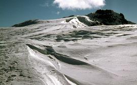
Part of Hal Wyatt Collection
Colour photograph of waves of ice, known as sastrugi, formed near the top of Naturalist Peak, photographed in 1971
Skiing at Mount Field National Park
Part of Hal Wyatt Collection
Colour photograph of skiers at Mount Field National Park, 1968.
Campsite near snow-capped summit of Florentine Peak
Part of Hal Wyatt Collection
Colour photograph shows three people standing outside a canvas tent pitched near the snow-capped summit of Florentine Peak
Sunset at Newdegate Pass, 1969
Part of Hal Wyatt Collection
Colour photograph of setting sun behind mountains at Newdegate Pass, 1969
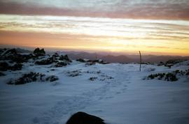
Footsteps in snow at Sunset atop Naturalist Peak, 1973
Part of Hal Wyatt Collection
Colour photograph of footsteps in the snow at sunset atop Naturalist Peak
Snow skiing near Florentine Peak 1959
Part of Hal Wyatt Collection
Colour photograph shows group of snowskiers adjusting equipment near Clemes Tarn and Florentine Peak, taken in 1959
Sunset atop Naturalist Peak, 1973
Part of Hal Wyatt Collection
Colour photograph sunset atop snow-capped Naturalist Peak
Part of Hal Wyatt Collection
Colour aerial photograph of Wombat Moor, Mount Field National Park
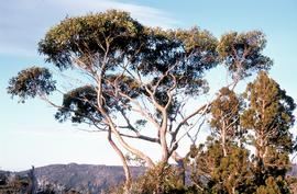
Eucalypt and pines near Twisted Tarn
Part of Hal Wyatt Collection
Colour photograph shows eucalypt tree growing beside pencil pines near Twisted Tarn

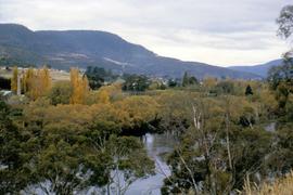
Steam train with passenger carriages crossing Derwent River
Part of Hal Wyatt Collection
Colour photograph shows steam locomotive with yellow passenger carriages crossing the Derwent River on a railway bridge near New Norfolk.
Hal Wyatt
Part of Hal Wyatt Collection
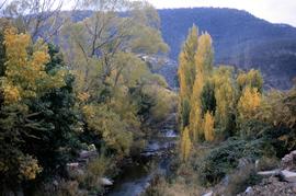
Colour photograph shows autumn foliage alongside the Lachlan River, near New Norfolk
Hal Wyatt
Part of Hal Wyatt Collection
Colour photograph shows autumn foliage at New Norfolk
Hal Wyatt
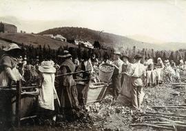
Part of Photographs of Edward Verrell
Black-and-white photograph shows men, women and children stripping hop cones into hessian-covered troughs, carrying baskets and sacks of harvested hops on the extensive hop grounds. The plant was cultivated widely at Glenorchy, Margate, Kingston and the Upper Derwent Valley area.
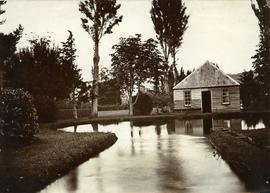
Part of Photographs of Edward Verrell
Photograph showing the first hatchery building built in 1870 at the Salmon Ponds at Plenty surrounded by landscaped grounds filled with exotic trees.
Part of De La Haye Postcard Collection
One hand coloured panorama image, captioned & numbered 23 , in proprietary envelope showing a panorama of New Norfolk.
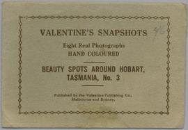
From envelope - Valentine's Snapshots. Eight real photographs. Hand coloured. Beauty spots around Hobart, Tasmania No.3. Published by the Valentine Publishing Co., Melbourne and Sydney.
Valentine Publishing

Part of De La Haye Postcard Collection
Ten captioned fold out colour images in proprietary post-able envelope. Showing views of Hobart and New Norfolk.
From envelope : A Colorful Souvenir of New Norfolk, Tas. Derwent Valley with Hobart. Up-to-Date Views. G & G Series.
Part of George Musgrave Parker : Correspondence and research records
Sketch thought to be by Douglas Pratt
George Musgrave Parker
Part of George Musgrave Parker : Correspondence and research records
Sketch by Roy Cox
George Musgrave Parker
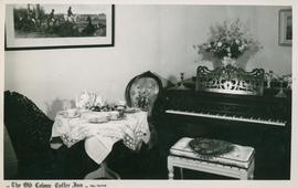
Postcard of the Old Colony Coffee Inn
Part of Olive Pink Collection
Black and white postcard of the interior of the Old Colonial Coffee Inn, New Norfolk, Tasmania
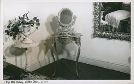
Postcard of the Old Colony Coffee Inn
Part of Olive Pink Collection
Black and white postcard of the interior of the Old Colonial Coffee Inn, New Norfolk, Tasmania
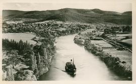
Postcard of a ferry on the Upper Derwent
Part of Olive Pink Collection
Black and white postcard of a ferry on the Upper Derwent River below New Norfolk, Tasmania
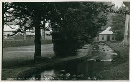
Part of Olive Pink Collection
Black and white postcard of the Salmon Ponds near New Norfolk, Tasmania, marked no. 79
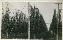
Postcard of hop fields near New Norfolk
Part of Olive Pink Collection
Black and white postcard of hop fields near New Norfolk, southern Tasmania marked 691
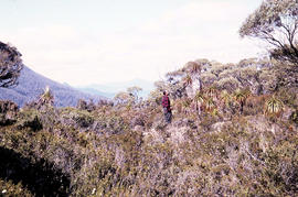
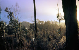
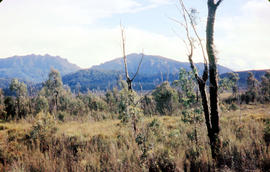
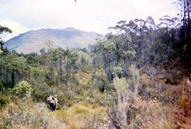
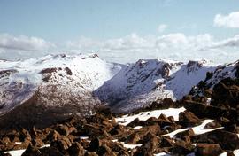
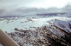
View of mountain ranges west of Mt. Lord
Part of Arthur Knight Slides
Colour photograph of mountain ranges west of Mt. Lord