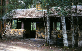
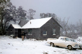
Picnic hut near National Park entrance
- AU TAS UTAS ITCCD 2017/2-199
- Item
Part of Arthur Knight Slides
Colour photograph shows picnic hut near road entrance of Mount Field National Park

Picnic hut near National Park entrance
Part of Arthur Knight Slides
Colour photograph shows picnic hut near road entrance of Mount Field National Park
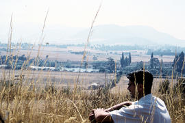
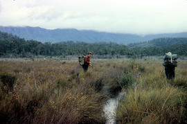
Man sitting in long grass at Plenty
Part of Arthur Knight Slides
Colour photograph shows many with dark hair and spectacles sitting on the edge of cleared farmland at Plenty beside river
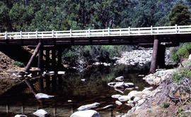
Timber bridge across Plenty River
Part of Arthur Knight Slides
Colour photograph shows the timber frame of the bridge across the Plenty River
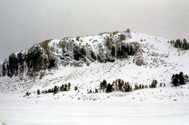
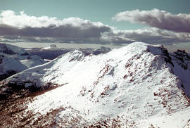
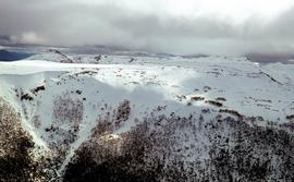
Part of Arthur Knight Slides
Colour photograph shows snow cover on the Rodway Range
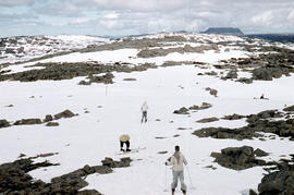
Man skiing downhill on Mount Field West
Part of Arthur Knight Slides
Colour photograph shows man skiing downhill at Mount Field West, with two other figures behind him near the summit of mountain
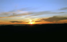
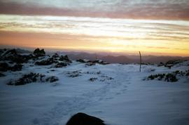
View of sunset from Rodway Range
Part of Arthur Knight Slides
Colour photograph shows sunset as viewed from Rodway Range
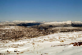
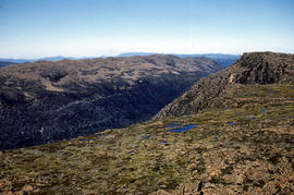
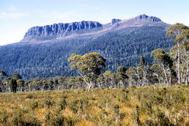
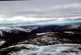
View of heathland near Mount Bowes
Part of Arthur Knight Slides
Colour photograph shows heathland looking southwest from near Mount Bowes
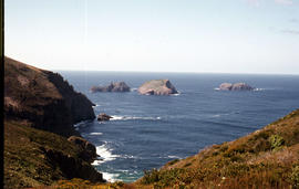
The Druids as viewed from Woody Island
Part of Arthur Knight Slides
Colour photograph shows The Druids as viewed from Woody Island
Part of Arthur Knight Slides
Colour photograph shows The Watcher
Aerial view of cars choking road near Baskerville race track
Part of Arthur Knight Slides
Colour aerial photograph shows cars travelling to Baskerville Raceway, which opened in 1958
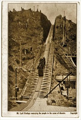
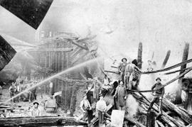
Mt Lyell Haulage conveying the people to the scene of the disaster
Part of Images of West Coast Tasmania
Image contains text identifying the subject and also 'copyright'. Originally taken from a postcard published in the weeks following the 1912 North Mount Lyell mine disaster. Image shows people in an open rail car travelling up the mountain.
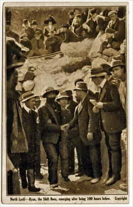
North Lyell - Ryan, the Shift Boss, emerging after being 100 hours below
Part of Images of West Coast Tasmania
Image contains text identifying the subject and also 'copyright'.Originally taken from a postcard published in the weeks following the 1912 North Mount Lyell mine disaster. Image shows people greeting Ryan as he moves towards the photographer, possibly with the mine entrance at the rear.
Colin Dennison (Curator)
View of a substantial, multi storey ruined building destroyed by fire, Queenstown Tasmania
Part of Images of West Coast Tasmania
The image shows many men standing within the ruins facing the camera as a hose plays water onto the building. Electronic file is titled 'after fire.tif'
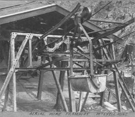
Aerial wire tramway Mt Lyell mine
Part of Images of West Coast Tasmania
Image has hand written legend on the original photo's mounting card. Image shows the lower entry point where cable wagons containing ore are received.
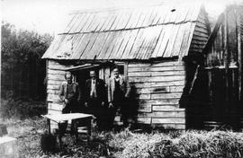
Part of Images of West Coast Tasmania
Image is identified as "Camp at Timbs Landing".
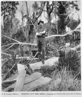
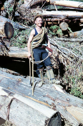
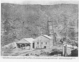
View of male axeman standing on fallen timber in the bush, Crotty, Tasmania.
Part of Images of West Coast Tasmania
Image likely sourced from a newspaper or publication as it contains printed legend at the bottom: Opening out of the west - clearing the land for the new town of Crotty. Photographer identified. Primitive buildings just visible in the background. It is likely the image is older than 1902.
F.E. Pousty
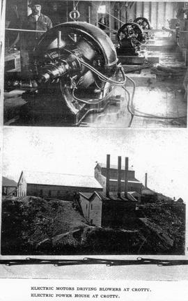
Two views of Crotty, Tasmania, showing electric machinery and power station.
Part of Images of West Coast Tasmania
Image likely sourced from a newspaper or publication as it contains printed legend at the bottom: electric motors driving blowers at Crotty (and of the lower image) Electric power house at Crotty.
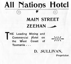
Advertising flyer for the All Nations Hotel, Zeehan, Tasmania
Part of Images of West Coast Tasmania
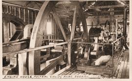
View of the engine house, Austral Valley Mine, Zeehan, Tasmania
Part of Images of West Coast Tasmania
Image has hand printed label giving title and date in bottom.
Part of Images of West Coast Tasmania
Image is likely sourced from a newspaper or publication as it shows legend at the bottom identifying the scene and providing technical information about the mine.

View of the Central Hotel, Zeehan, Tasmania
Part of Images of West Coast Tasmania
Image likely sourced from a newspaper or publication as it has a printed legend at the bottom stating that the "Photo taken during stay of Royal Welsh Male Choir at the Hotel." Label added later identifying the subject and date.
View of a wood chopping competition, Zeehan, Tasmania
Part of Images of West Coast Tasmania
Image shows a spectators around an area used for wood chopping.
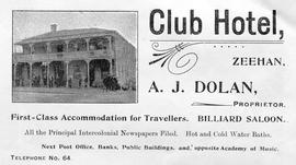
View of the Club Hotel, Zeehan, Tasmania
Part of Images of West Coast Tasmania
Image is an advertisement with the Hotel in the centre and text above and below providing the name, address, proprietor and telephone number.
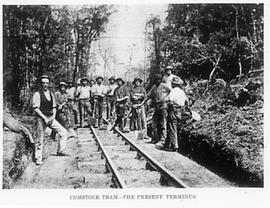
View of the rail (tram) terminus at Comstock, near Zeehan, Tasmania
Part of Images of West Coast Tasmania
Image likely sourced from newspaper or publication as it provides a printed legend at the bottom. Image shows workers standing on the rail line with shovels.
Adventure Bay near Cape Queen Elizabeth
Part of Arthur Knight Slides
View from headland of Adventure Bay near Cape Queen Elizabeth on Bruny Island.
Arthur Knight
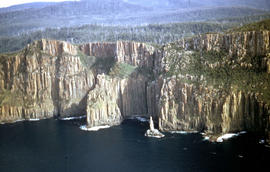
View of Cape Connella from the air
Part of Arthur Knight Slides
Colour aerial photograph of cliffs of Cape Connella, viewed from the air.
Setting sun shines on headland east of Cloudy Bay
Part of Arthur Knight Slides
Colour photograph of headland east of Cloudy Bay, illuminated by low setting sun.
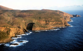
View of the Friars from shore near Pine Log Bight
Part of Arthur Knight Slides
Colour photograph of the Friars, a small group of islands, off southern shore of Bruny Island, taken from shore near Pine Log Bight.
Part of Arthur Knight Slides
Colour photograph shows snow-covered slope on Ben Lomond

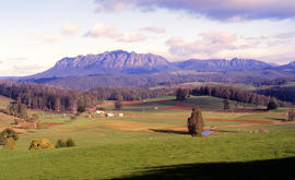
Part of Arthur Knight Slides
Colour photograph shows open paddock and mature eucalypt trees with Ben Lomond in the distance
Part of Arthur Knight Slides
Colour photograph of snow skiers on Ben Lomond
Carr Villa Chalet at Ben Lomond 1962
Part of Arthur Knight Slides
Colour photograph shows two people inspecting a gas cylinder outside the Carr Villa Chalet atop the treeline at Ben Lomond

Part of Arthur Knight Slides
Colour photograph shows cliffs near Stacks Bluff

Part of Arthur Knight Slides
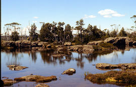
Colour photograph shows shoreline of Cloister Lagoon GIS: Latitude -4189 Longitude 14617 Gazetteer Australia Record_ID TAS02046

Part of Arthur Knight Slides
Colour photograph shows Lake Lea in foreground, with Cradle Mountain and Barn Bluff in distance

Part of Arthur Knight Slides
Colour photograph shows flecks of snow on upper ridges of Cradle Mountain and land around Dove Lake, some of it cloaked in deep shadow

Cradle Mountain from Hansons Peak
Part of Arthur Knight Slides
Colour photograph of Cradle Mountain as viewed from nearby Hansons Peak

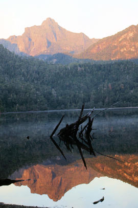
Part of Arthur Knight Slides
Colour photograph shows shoreline of Crater Lake with sunlit cliffs on opposite bank

Part of Arthur Knight Slides
Colour photograph shows Volkswagen combi van being driven through floodwaters across Midland Highway 1964

Snow on banks of River Derwent 1986
Part of Arthur Knight Slides
Colour photograph shows snow on the shoreline of River Derwent 1986

Part of Arthur Knight Slides
Colour photograph shows icicles formed on Little Horn 1985

Lake Loane under snow cover 1978
Part of Arthur Knight Slides
Colour photograph shows Lake Loane beneath blanket of snow, from near the Horse Track 1978

Part of Arthur Knight Slides
Colour photograph shows waves and white caps on the surface of Lake Myrtle GIS: Latitude -4188 Longitude 14618 Gazetteer Australia Record_ID TAS02073
Part of Arthur Knight Slides
Colour photograph shows silhouette of Mount Anne, viewed at sunset
Part of Arthur Knight Slides
Colour photograph shows cloud above mountain ranges, looking west to Mount Heemskirk from Mount Murchison
Part of Arthur Knight Slides
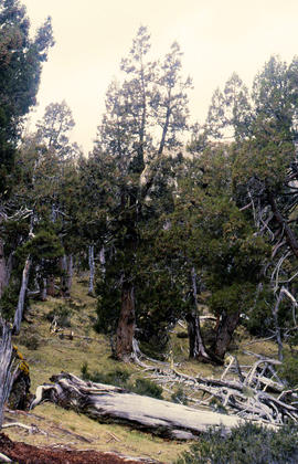
Colour photograph shows Pencil Pines growing in alpine forest near Dixons Kingdom hut
Tarn and Pencil Pines near Mountains of Jupiter
Part of Arthur Knight Slides
Colour photograph shows alpine vegetation surrounding Pool of Bethesda GIS: Latitude -4181 Longitude 14630 Gazetteer Record_ID TAS12063
Part of Arthur Knight Slides
Colour photograph shows patterned bark of snow gum near Cathedral Mountain
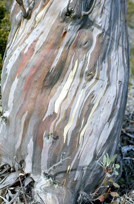
Bark of snow gum near Cathedral Mountain
Part of Arthur Knight Slides
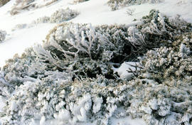
Colour photograph shows ice formations on tufts of native grass
Part of Arthur Knight Slides
Colour photograph shows snow covering alpine vegetation
Part of Arthur Knight Slides
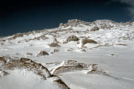
Colour photograph shows snow cover around Mount Rogoona
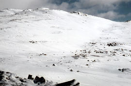
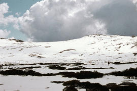
Snow on plateau below Mount Rogoona
Part of Arthur Knight Slides
Colour photograph shows southern shore of Lake Timk
Snow cover on Ben Lomond plateau near summit 1960
Part of Arthur Knight Slides
Colour photograph shows summit of Ben Lomond 1962
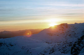
Summit of West Wall at Mount Jerusalem
Part of Arthur Knight Slides
Colour photograph shows sunrise at Cradle Mountain 1976
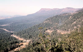
Part of Arthur Knight Slides
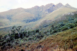
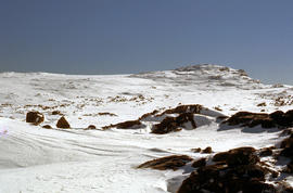
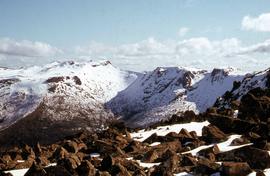
Colour photograph shows view of mountain range to the west of Mount Field West
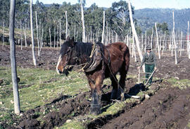
Man and horse ploughing at Westerway
Part of Arthur Knight Slides
Colour photograph shows a farmer ploughing a paddock at Westerway in a field strung with trellis frames for hop cultivation with a draught horse and plough
Part of Arthur Knight Slides
Colour photograph depicts northern shoreline of Great Lake and settlement of Breona
Arthur Knight
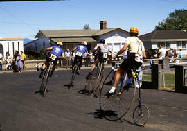
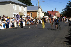
Penny farthing bicycle races at Evandale
Part of Arthur Knight Slides
Colour photograph shows cyclists in heat 4 of the penny farthing championships of 1984 in Evandale
Arthur Knight
Part of Arthur Knight Slides
Colour photograph shows snow on Mount Olympus as viewed from near Narcissus hut, near Lake St Clair
Arthur Knight
Part of Arthur Knight Slides
Colour photograph shows snow cover on Mount Ossa
Arthur Knight
Poatina Road snakes down Western Tiers
Part of Arthur Knight Slides
Colour photograph shows road snaking down the Western Tiers near Poatina
Arthur Knight
Part of Arthur Knight Slides
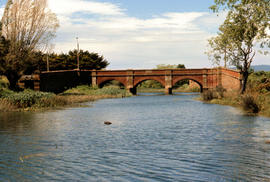
Colour photograph shows the Red Bridge, a convict built arch bridge across Elizabeth River at Campbell Town
Arthur Knight
Part of Arthur Knight Slides
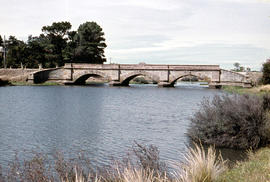
Colour photograph shows the arches of the sandstone bridge at Ross that leads across the Macquarie River
Arthur Knight
Part of Arthur Knight Slides
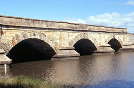
Colour photograph shows fast-flowing water of the Macquarie River at the Ross Bridge
Arthur Knight
Part of Arthur Knight Slides
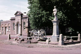
Colour photograph shows the Ross War Memorial
Arthur Knight
Penny farthing relay at Evandale
Part of Arthur Knight Slides
Colour photograph depicts northern shoreline of Great Lake and settlement of Breona
Arthur Knight
Part of Hal Wyatt Collection
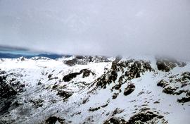
Colour photograph shows snow on mountains in Tasmania’s Central Highlands
Part of Hal Wyatt Collection
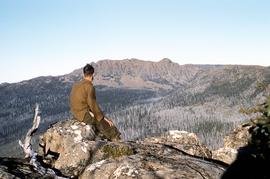
Colour photograph shows man sitting on rock atop Mount Marian looking across valley to Collins Bonnet

Part of Hal Wyatt Collection
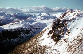
Colour photograph shows Denison Range covered in patchy snow
Part of Hal Wyatt Collection
Colour aerial photograph shows snow on Florentine Peak and Mount Field West
Florentine Peak from Mawson Plateau
Part of Hal Wyatt Collection
Colour photograph shows Florentine Peak from Mawson Plateau, 1968.
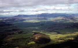
Aerial view of farmland at Glenora
Part of Hal Wyatt Collection
Colour aerial photograph of farmland at Glenora
Part of Hal Wyatt Collection
Colour aerial photograph of Golden Stairs on Mount Mawson
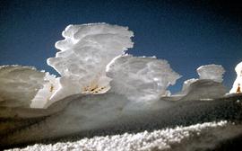
Ice on bushes at Newdegate Pass
Part of Hal Wyatt Collection
Colour photograph of ice on bushes at Newdegate Pass, 1970

Part of Hal Wyatt Collection
Colour photograph of people skiing at Mount Mawson
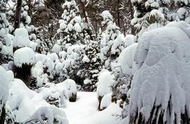
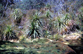
Snow and ice on grove of Pandanus trees
Part of Hal Wyatt Collection
Colour photograph of ice on grove of Pandanus trees
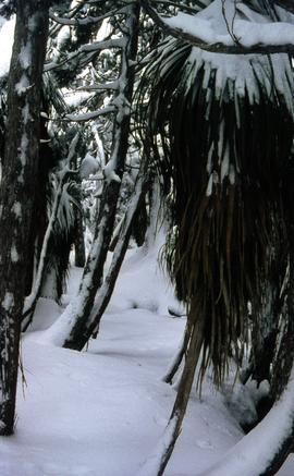
Snow and ice beneath rainforest trees
Part of Hal Wyatt Collection
Colour photograph of ice and snow beneath rainforest plants, 1970
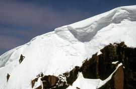
Snow climbers near mountain ridge
Part of Hal Wyatt Collection
Colour photograph of two snow climbers on a steep section of snow under a mountain ridge, possibly near Mount Field
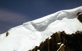
Part of Hal Wyatt Collection
Colour photograph of snow climber nearing a ridge on a snow-covered mountain, possibly near Mount Field
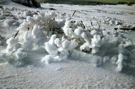
Ice and snow formation on mountain plants
Part of Hal Wyatt Collection
Colour photographs of ice and snow encrusting plants on mountain plain
Footsteps in snow at Sunset atop Naturalist Peak, 1973
Part of Hal Wyatt Collection
Colour photograph of footsteps in the snow at sunset atop Naturalist Peak
Part of Hal Wyatt Collection
Colour aerial photograph of Wombat Moor, Mount Field National Park