- AU TAS UTAS ITCCD 2017/14-3
- Unidad documental simple
- 1970-1980
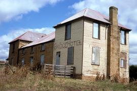
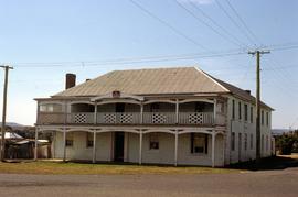
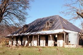
Colour landscape photograph shows exterior of derelict Bridge Hotel at Ouse, situated in the crook of the Ouse River, a sandstone, weatherboard and tin structure, with windows boarded up

Colour landscape photograph shows exterior of derelict Bridge Hotel at Ouse, situated in the crook of the Ouse River, a sandstone, weatherboard and tin structure, with windows boarded up
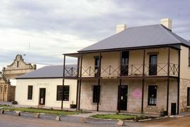
Colour photograph shows former Bridge Inn Richmond, a sandstone building at 50 Bridge Road, Richmond, with confectioner trading as Sweets and Treats.
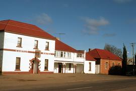
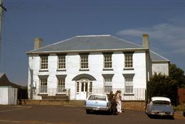
Colour photograph of Castle Hotel, 14 Patrick Street, Bothwell, a white-painted late Georgian-style building with red corrugated iron hip-roof
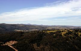
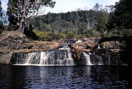
Colour landscape photograph of heavily forested area at Staverton and Cethana, in the Kentish Municipality, near Sheffield, Tasmania.
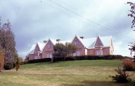
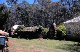
View of Clifton Priory and powerlines across front lawn
Colour photograph of Clifton Priory, Bothwell, showing powerlines across front lawn below hedge. National heritage register citation is as follows: “Two storey stone Tudor Gothic house built in 1847-8 by Rev. Robert Wilson from public subscription. Wilson caused a scandal when he ran into financial difficulties and sold it owing a considerable sum. The house is magnificently sited on Barrack Hill from where it enjoys fine views of Bothwell, the Clyde River and surrounding countryside.”
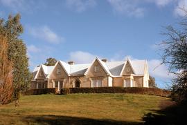
View of Clifton Priory atop Barrack Hill, Bothwell
Colour photograph of Clifton Priory, Bothwell, showing gardens, lawn and hedge below front door. National heritage register citation is as follows: “Two storey stone Tudor Gothic house built in 1847-8 by Rev. Robert Wilson from public subscription. Wilson caused a scandal when he ran into financial difficulties and sold it owing a considerable sum. The house is magnificently sited on Barrack Hill from where it enjoys fine views of Bothwell, the Clyde River and surrounding countryside.”
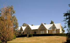
Clifton Priory atop Barrack Hill, Bothwell
Colour photograph of Clifton Priory, Bothwell. National heritage register citation is as follows: “Two storey stone Tudor Gothic house built in 1847-8 by Rev. Robert Wilson from public subscription. Wilson caused a scandal when he ran into financial difficulties and sold it owing a considerable sum. The house is magnificently sited on Barrack Hill from where it enjoys fine views of Bothwell, the Clyde River and surrounding countryside.”
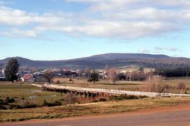
View of Clyde River Bridge, Bothwell, Tasmania
Colour photograph of timber bridge across Clyde River, Bothwell, Tasmania
People standing outside former Coffee Palace, Bothwell
Colour photograph of people standing beside motor vehicles parked outside former coffee palace, hotel and doctor’s surgery at 90 Dalrymple Street Bothwell. Citation on National heritage register: “A two storey brick and stucco Georgian building with a stone rear section, licensed as the Young Queen from 1851-1877 when the name was changed to Maskell's Hotel. The building appears in a book on Colonial architecture by Hardy Wilson with a crinolined lady at the doorway with luggage and bird cage. The building is an important townscape element.”
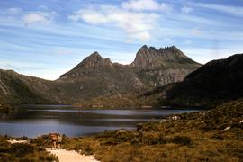
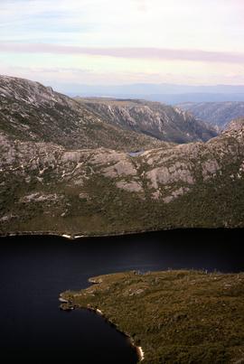
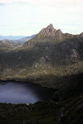
Colour photograph of Cradle Mountain, taken from track near Marion’s Lookout
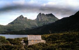
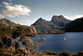
View of Cradle Mountain, Dove Lake and boatshed
Colour photograph shows Cradle Mountain, Dove Lake and boatshed,
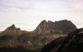
View of Cradle Mountain and Barn Bluff
Colour photograph of view towards Cradle Mountain and Barn Bluff, showing scree and boulders on mountain tops near Devils Gullet and Fisher Power Station in foreground
Walkers setting out on track near Dove Lake
Colour photograph shows walkers setting out on track near Dove Lake below Cradle Mountain
Colour photograph shows Cradle Mountain, with dinghy being rowed on Dove Lake in foreground

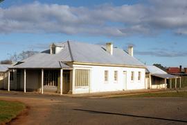
Former Crown Inn, reopened as The Crown Lodge at Bothwell
Colour photograph shows Ford XF Falcon motor vehicle parked out front of the Crown Lodge, 15 Alexander Street Bothwell, with sandwich board and hand painted “Now Open” sign
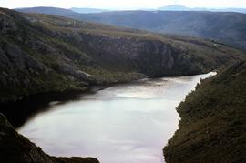
View of Crater Lake, near Cradle Mountain
Colour photograph shows Crater Lake, near Cradle Mountain
Colour photograph shows former Crown Inn at 15 Alexander Street, Bothwell, with distinctive colour crown insignia above first-storey veranda and coloured light globes mounted along balcony
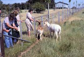
Visitors feeding fallow deer at Thorpe Farm, Bothwell
Colour photograph shows deer being offered food by visitors to Thorpe Farm, where fallow deer is farmed by the Bignell family, Bothwell.
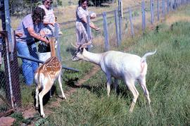
Deer being fed at Thorpe Farm, Bothwell
Colour photograph shows deer being offered food by visitors to Bothwell
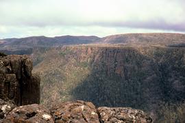
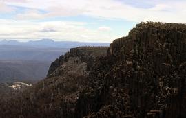
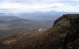
View from Devils Gullet lookout
Colour photograph shows view from Devils Gullet Lookout off Lake McKenzie Road
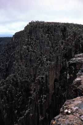
Colour photograph shows view from Devils Gullet Lookout
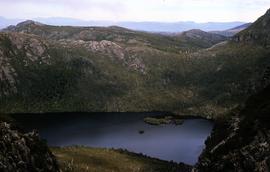
View of Dove Lake and Honeymoon Island
Colour photograph shows Honeymoon Island in Dove Lake, near Cradle Mountain
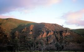
Low sun at Meadsfield near Bothwell
Colour photograph shows hilltop and lightly timbered landscape at Meadsfield near Bothwell, photographed in evening sunlight
View towards Barn Bluff and Cradle Mountain from Devils Gullet
Colour photograph shows view from Devils Gullet Lookout towards Cradle Mountain and Barn Bluff with earthworks surrounding Fisher Power Station on hill in foreground

Knyvet Falls near Cradle Mountain
Colour photograph shows water flowing over Knyvet Falls in the Cradle Valley
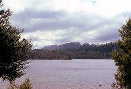
Lake Hanson near Cradle Mountain
Colour photograph shows Lake Hanson, near Cradle Mountain
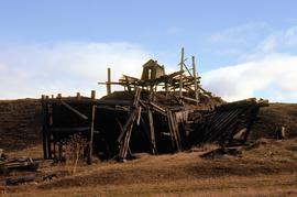
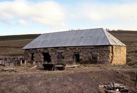
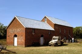
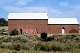
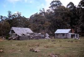
Ruins of structure at Langloh Coal Mine near Hamilton
Colour photograph shows fallen timber structures at Langloh coal mine and colliery near Hamilton
View of Little Horn of Cradle Mountain and Dove Lake
Colour photograph of Little Horn and Dove Lake, Cradle Mountain
Ruins of Langloh Coal Mine near Hamilton
Colour photograph shows ruins of Langloh colliery near Hamilton
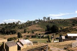
Farm buildings at Meadsfield near Bothwell
Colour photograph of farm buildings at Meadsfield near Bothwell
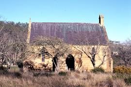
Colour photograph taken in winter showing side view of St James Chapel at Montacute, with the Hallett family serving as caretakers, since 1897
Trees overshadowing abandoned slate-roofed dwelling on Montacute property
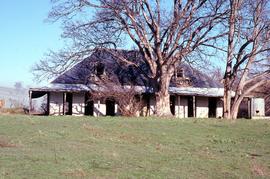
Colour photograph of substantial shingle-roofed dwelling with dormer windows and wrap-around veranda on the property at Montacute, Hollow Tree, overshadowed by mature deciduous trees, photograph taken July 1981
View of church yard surrounding St James chapel at Montacute
Colour photograph taken in winter, shows burial ground and churchyard surrounding St James Chapel at Montacute, under the care of the Hallett Family, since 1897
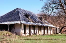
Abandoned slate-roofed homestead at Montacute
Colour photograph of slate-roofed dwelling with dormer windows and veranda on the property at Montacute, Hollow Tree
Front view of abandoned shingle-roofed dwelling on Montacute property
Colour photograph showing front of substantial slate-roofed dwelling with dormer windows and wrap-around veranda on the property at Montacute, Hollow Tree, photograph taken July 1981
Colour landscape photograph of property Cawood, Ouse,
View to Mount Olympus across Lake St Clair
Colour photograph shows Mount OIympus in distance across Lake St Clair
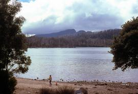
View of shoreline of Lake St Clair looking to Mount Olympus
Colour photograph shows people on beach of shoreline at Lake St Clair, with cloud cover above Mount OIympus in distance
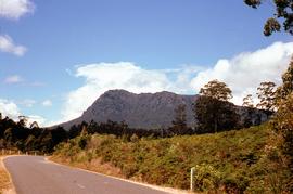
Colour photograph shows Mount Roland from Cethana, with road in foreground
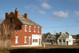
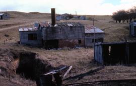
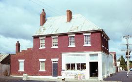
Old shop and post office at Bothwell
Colour photograph shows Bothwell Stores shop and post office at Bothwell
Colour photograph shows disused shop at Bothwell
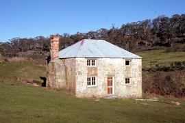
Stone dwelling at Sherwood, Hollow Tree
Colour photograph of stone dwelling at Sherwood, a property at Hollow Tree
Pencil pine falls at Cradle Valley
Colour photograph of water flowing over Pencil Pine falls near Cradle Mountain
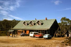
Colour photograph of Pencil Pine Lodge near Cradle Mountain, with cars parked outside accommodation block near Golden Fleece petrol bowser
Front door of Sherwood at Hollow Tree
Colour photograph of front entrance to Sherwood, property at Hollow Tree
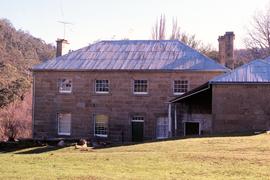
Side view of Sherwood homestead
Colour photograph of sandstone building, Sherwood, at Hollow Tree
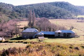
View of Sherwood, homestead in Clyde River Valley
Colour photograph of sandstone homestead, Sherwood, with nearby outbuildings, willows lining the banks of nearby Clyde River at Hollow Tree
Front view of Sherwood, sandstone homestead at Hollow Tree
Colour photograph of sandstone homestead, Sherwood, with nearby outbuildings
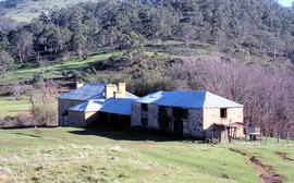
Colour photograph of sandstone homestead, Sherwood, with farm outbuildings and Clyde River Valley
Dog on footpath outside Bothwell store
Colour photograph of Bothwell store, with dog standing on footpath and newspaper posters promoting stories in The Mercury and The Examiner about State Cabinet reshuffle under Neilson government
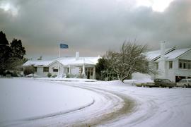
Colour photograph of snow on timber hut and outbuildings at Wihareja
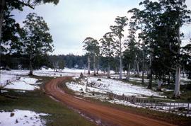
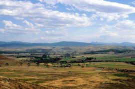
Colour photograph shows red dirt road through Victoria Valley, with snow cover on paddocks
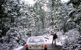
Colour photograph shows man standing beside Subaru station wagon on road through snow-covered forest near Tarraleah
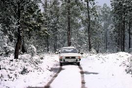
Car on road with snow near Tarraleah
Colour photograph Subaru on the snow-covered road near Tarraleah
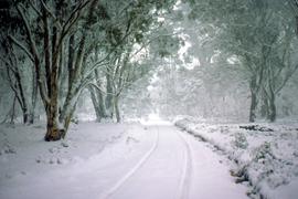
Tyre tracks in snow on Marlborough Highway
Colour photograph shows tyre tracks in heavy snow on Marlborough Highway, linking Lyell Highway and Lake Highway
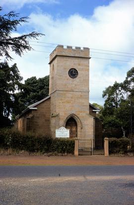
St Lukes Presbyterian Church at Bothwell
Colour portrait-shaped photograph of St Lukes Presbyterian Church, Bothwell, a sandstone building, with clocktower showing a quarter past midday
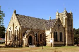
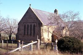
St Michaels Anglican Church, Bothwell
Colour landscape photograph of sandstone church at Bothwell, the St Michael’s Anglican Church, consecreated in 1891.
Stable ruins at Langloh Colliery
Colour photograph of abandoned Langloh coalmine and colliery near Hamilton
Colour photograph of exterior of the Steppes homestead, on the Lake Highway
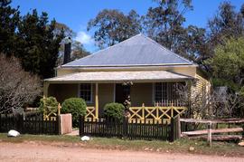
Front view of Steppes Homestead
Colour photograph of front of the Steppes homestead near Miena, on the Lake Highway
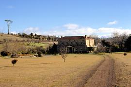
Strathborough homestead at Hollow Tree
Colour photograph of sandstone homestead, Strathborough, taken in July 1981, at Hollow Tree
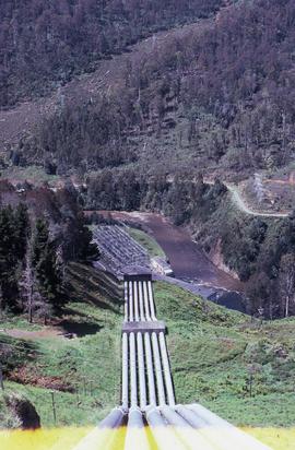
Headrace at Tarraleah Power Station
Colour photograph looking downhill to Tarraleah Power Station
Snow covers cars at Tarraleah Chalet
Colour photograph shows snow at Tarraleah Chalet, covering cars in car park
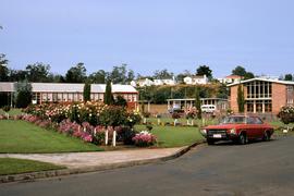
Colour photograph shows red Holden Kingswood parked outside buildings at Tarraleah in March 1983, including the TAB office, fuel station and former school, with garden bed of blooming roses and annuals
Colour photograph shows Toyota Landcruiser parked outside Thorpe Water Mill at Bothwell
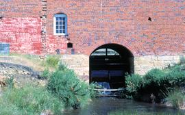
Side view of water course beneath Thorpe Water Mill at Bothwell
Colour photograph shows water flowing beneath Thorpe Water Mill at Bothwell
Colour photograph shows new shingle roof and restored timber work on Waldheim Chalet at Cradle Mountain
Water wheel at Thorpe Water Mill, Bothwell
Colour photograph shows water wheel beneat the Thorpe Water Mill at Bothwell
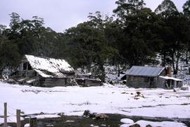
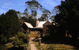
Hut, barn and wagons at Wihareja
Colour photograph of timber hut, barn and wagons at Wihareja
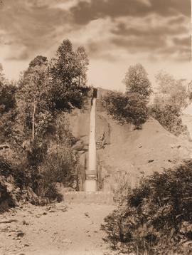
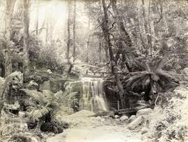
Water flows down Gentle Annie Falls
Parte dePhotographs of Edward Verrell
Black-and-white photograph of Gentle Annie Falls, a man-made water channel constructed as part of the Hobart waterworks to supply fresh water to residents of Hobart, operating between the 1860s to 1940s.
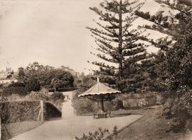
Decorative seat at Royal Botanical Gardens
Parte dePhotographs of Edward Verrell
Black-and-white photograph of Royal Botanical Gardens, showing a decorative undercover seat constructed around the stump and butt of a tree. Government House visible in background
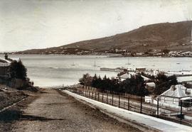
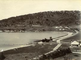
View from Bath Street, Battery Point
Parte dePhotographs of Edward Verrell
Black-and-white photograph of Bath Street, Battery Point, looking across Derwent River to Sandy Bay and St Helena Point.
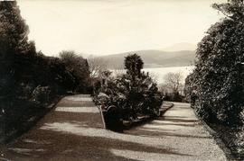
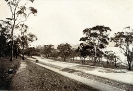
Walking path in Royal Botanical Gardens
Parte dePhotographs of Edward Verrell
Black-and-white photograph shows gravel walking path in Royal Botanical Gardens
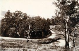
Lower Domain Road at back of Royal Botanical Gardens
Parte dePhotographs of Edward Verrell
Black-and-white photograph of road crossing a pond on Lower Domain Road near Royal Botanical Gardens. Towers of Government House visible behind trees.
Parte dePhotographs of Edward Verrell
Black-and-white photograph looking south at Cornelian Bay on the Derwent River, with one boatshed on far shore
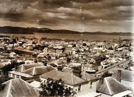
Rooftops of Hobart looking east
Parte dePhotographs of Edward Verrell
Black-and-white photograph shows view of Hobart rooftops looking east over central city streets including Harrington Street and Murray Street
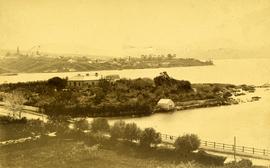
View of Dunkleys Point at Sandy Bay
Parte dePhotographs of Edward Verrell
Black-and-white photograph shows Sandy Bay Road in foreground, the grand home St Helena on what is known as Dunkleys Point, and Battery Point on the opposite shore of the bay
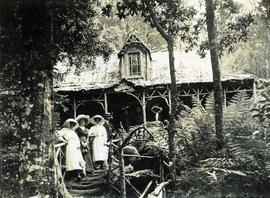
Visitors at Falls Hut, Mount Wellington
Parte dePhotographs of Edward Verrell
Black-and-white photograph shows visitors standing on front steps and veranda at Falls Hut, built 1897, at the Cascades, on road to Mount Wellington
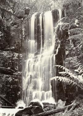
Men posing for camera at Silver Falls
Parte dePhotographs of Edward Verrell
Black-and-white vertical/portrait photograph of four men posing for the camera while standing or squatting above or beside a waterfall on Mount Wellington, believed to be Silver Falls
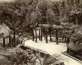
Parte dePhotographs of Edward Verrell
Black-and-white photograph shows walking path at Fern Tree Bower, Mount Wellington
Parte dePhotographs of Edward Verrell
Black-and-white photograph shows path to near base of waterfall in foothills of Mount Wellington, two men standing near a barrel beside a metal mesh and barbed wire fence and a padlocked gate barring access to the stream
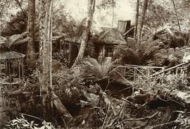
Parte dePhotographs of Edward Verrell
Black-and-white photograph of rustic hut built amid fern trees on walking track at Mount Wellington, two figures walking across timber bridge amid fern fronds
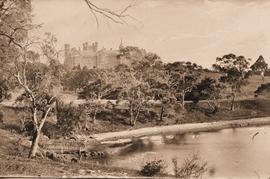
Government House in Hobart, viewed from the river, across Rose Bay
Parte dePhotographs of Edward Verrell
Black-and-white photograph shows waves lapping shoreline of Derwent River in foreground, with Government House on the hill, surrounded by mature trees, tall picket fence runs parallel with river, two wires strung between poles, visible through trees
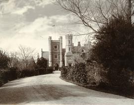
Western approach to Government House
Parte dePhotographs of Edward Verrell
Black-and-white photograph shows gravel road leading to western approach to Government House, Hobart, featuring clocktower with Union Jack hoisted and bas relief sculpture above doorway.
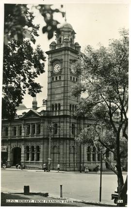
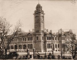
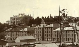
Hobart General Post Office from Franklin Park
Parte dePhotographs of Edward Verrell
Black-and-white photograph shows Hobart General Post Office viewed from Franklin Park. Words “G.P.O., HOBART, FROM FRANKLIN PARK” and “V6” are typewritten in black on white reverse panel at bottom of photograph
Hobart Railway Station, taken from university gardens
Parte dePhotographs of Edward Verrell
Black-and-white photograph shows Hobart Railway Station, viewed from gardens of the University of Tasmania, including the Tasmanian Government Railways workshops
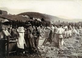
Parte dePhotographs of Edward Verrell
Black-and-white photograph shows men, women and children stripping hop cones into hessian-covered troughs, carrying baskets and sacks of harvested hops on the extensive hop grounds. The plant was cultivated widely at Glenorchy, Margate, Kingston and the Upper Derwent Valley area.
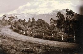
View of snow on Mount Wellington from Huon Road
Parte dePhotographs of Edward Verrell
Black-and-white photograph shows snow on Mount Wellington viewed from the verge of the Huon Road, South Hobart, with post-and-rail fence alongside roadway.
Parte dePhotographs of Edward Verrell
Black-and-white photograph shows dwellings, fences and farmland at Lindisfarne Bay, looking across Derwent River to Hobart
View from Queens Domain looking north to Cornelian Bay and New Town Bay
Parte dePhotographs of Edward Verrell
Black-and-white photograph taken from elevated point on Queen’s Domain, looking north up Derwent River towards Cornelian Bay and New Town Bay; Risdon Park Racecourse (1880s-1926) at New Town in foreground, early burial plots in headland of Cornelian Bay Cemetery at right of picture.
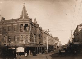
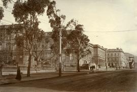
Miller’s Corner at Liverpool and Murray streets, Hobart
Parte dePhotographs of Edward Verrell
Black-and-white photograph depicts Miller’s Corner on the intersection of Liverpool Street and Murray streets, Hobart, looking towards waterfront down Murray Street. A.P. Miller, dispensing chemist, died 1904
Hobart GPO before installation of clock in tower
Parte dePhotographs of Edward Verrell
Black-and-white photograph shows Hobart General Post Office viewed from Franklin Park before the installation of the clock in the clocktower.
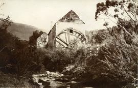
Water mill on New Town Rivulet
Parte dePhotographs of Edward Verrell
Black-and-white photograph shows water wheel on outside of mill on New Town Rivulet at Lenah Valley
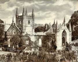
Ruins of church at Port Arthur
Parte dePhotographs of Edward Verrell
Black-and-white photograph shows ruins of the church at Port Arthur, damaged by fire in 1884,with charred timber framework in the roof, remnant shingles on the roof and climbing plants covering the sandstone of the church walls. Handwritten words “Church at Port Arthur” in lower left corner of image.
Elevated view of church ruins at Port Arthur
Parte dePhotographs of Edward Verrell
Black-and-white photograph shows elevated view of ruined church at Port Arthur, including charred timber roof framework; with view of waterfront and other buildings on Port Arthur site; cut hay is drying in paddock at front of church.
Public buildings near Franklin Square, Hobart
Parte dePhotographs of Edward Verrell
Black-and-white photograph shows public buildings near Franklin Square, Hobart
Road to Government House, on Gun Carriage Drive
Parte dePhotographs of Edward Verrell
Black-and-white photograph taken looking north along Gun Carriage Drive towards Government House, Hobart, with post-and-rail fences on Derwent River side; a horse harnessed to a four-wheel carriage, is on the left of the road; a small jetty extends from the shoreline and a boat is visible through the trees, anchored just off shore.
Parte dePhotographs of Edward Verrell
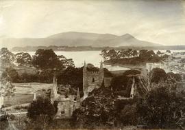
Black-and-white photograph shows stone buildings along Salamanca Place, timber stacked on New Wharf and masts of ships docked at the wharf; signs on buildings for “A.E. Lord Wool Merchant” and “W.D. Peacock and Co.”, historic home Lenna and eastern conservatory visible on hilltop behind towards Battery Point; maritime signal station with the Time Ball that was dropped automatically at 1pm, after a relayed telegraph signal from the Melbourne Observatory.
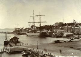
Ships docked at New Wharf, Hobart
Parte dePhotographs of Edward Verrell
Black-and-white photograph shows sailing ships moored at New Wharf, Hobart, in front of Salamanca Place, with milled timber stacked on edge of wharf
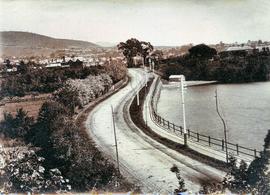
Sandy Bay Road looking towards Hobart
Parte dePhotographs of Edward Verrell
Black-and-white photograph shows Sandy Bay Road, with tram tracks on riverside of road, electric wires for Hobart Electric Tramway, carriage wheelmarks in the unpaved road surface, electricity transmission wires strung from poles mounted with porcelain insulators