
- AU TAS UTAS ITCCD 2017/2-310
- Item
- 1974
Parte de Arthur Knight Slides
Colour photograph shows Lake Timk and Mount Anne in distance GIS: Latitude -4293 Longitude 14646 Gazetteer Australia Record_ID TAS16882
Parte de Arthur Knight Slides
Colour photograph shows Lake Timk and Mount Anne in distance GIS: Latitude -4293 Longitude 14646 Gazetteer Australia Record_ID TAS16882
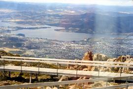
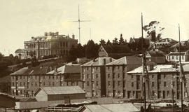
Glenorchy from Mount Wellington
View of Glenorchy and surrounds taken from Mt Wellington. Bowen Bridge visible. The photographic print features a lighter band visible on the scanned digital version.
Graeme Raphael
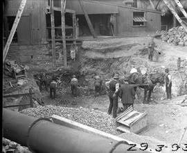
Derwent Prime furnace jacket assembled at E.Z. Co. Zinc Works
Black-and-white photograph shows men assembling Derwent Prime furnace at E.Z. Co. Zinc Works at Risdon
Parte de Photographs of Edward Verrell
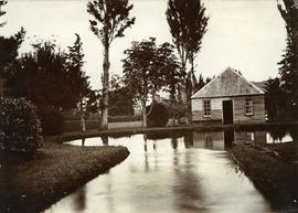
Photograph showing the first hatchery building built in 1870 at the Salmon Ponds at Plenty surrounded by landscaped grounds filled with exotic trees.
Multi-storied building with lettering reading Westway on corner, forming part of Cadbury factory.
Ruins of Langloh Coal Mine near Hamilton
Parte de Greg Dickens Photographic Collection
Colour photograph shows ruins of Langloh colliery near Hamilton

Walkers on Mountains of Jupiter
Parte de Arthur Knight Slides
Colour photograph of bushwalkers at Mountains of Jupiter near the Walls of Jerusalem

Parte de Arthur Knight Slides
Colour portrait format photograph shows Lake Wilks and Little Horn near Cradle Mountain
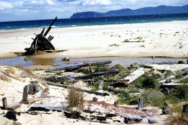
Wreck on beach near Mars Bluff
Parte de Arthur Knight Slides
Colour photograph of rotting timbers from wreck of boat, half-buried in the sand near shallow creek on beach near Mars Bluff, Bruny Island, Photograph possibly taken 1963.
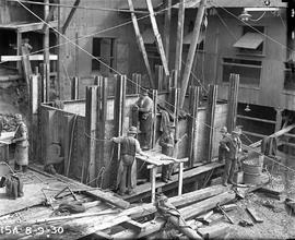
Excavation work for construction of furnace at E.Z. Co. Zinc Works
Black-and-white photograph shows workmen beginning excavation of site for new Derwent Prime furnace
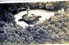
View from above of John Franklin Statue and Fountain, Franklin Square, Hobart.
Graeme Raphael
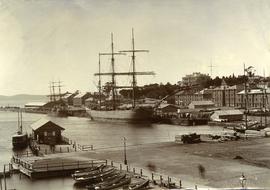
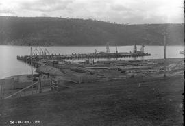
Ships docked at New Wharf, Hobart
Parte de Photographs of Edward Verrell
Black-and-white photograph shows sailing ships moored at New Wharf, Hobart, in front of Salamanca Place, with milled timber stacked on edge of wharf
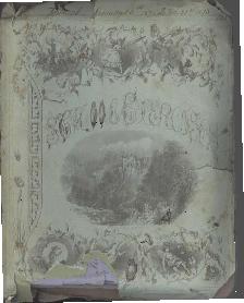
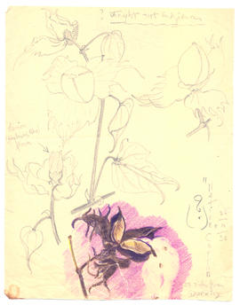
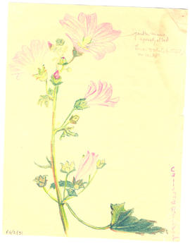
Parte de Cotton Family Papers
Quarto Farm journal dated 1881 - 1886. Decayed and crumbly at top of pages
Francis Cotton
Multi-story buildings, Cadbury Factory
Courtyard and paths between multi-storied buildings, Cadbury factory.
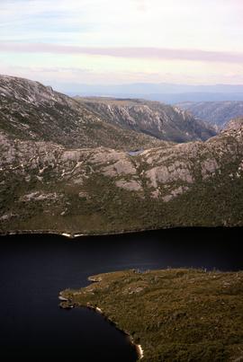
Lake Hanson near Cradle Mountain
Parte de Greg Dickens Photographic Collection
Colour photograph shows Lake Hanson, near Cradle Mountain
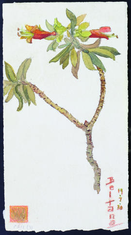
Parte de Olive Pink Collection
Watercolour painted by Olive Pink at Beltana, South Australia 19/7/30. Identified by Olive Pink as Eremophila maculata
Olive Pink
Parte de Olive Pink Collection
Black and white photograph of bird bath under fig tree from south door of Hut 2
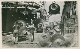
Postcard of shipping Tasmanian apples
Parte de Olive Pink Collection
Humorous postcard showing giant apples being shipped from Tasmanian wharf. Beattie postcard
Parte de De La Haye Postcard Collection
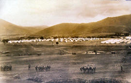
Soldiers being drilled at Claremont Military Camp
Soldiers being drilled in front of large group of military tents, part of the Claremont military camp.
Parte de Arthur Knight Slides
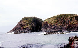
Arch island on Bruny Island
Arthur Knight
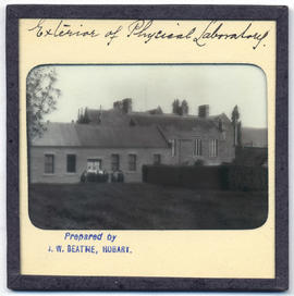
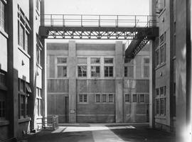
Exterior of physical laboratory at the rear of Domain House
Parte de Photographic reproduction collection
Exterior of physical laboratory at the rear of Domain House, Hobart.
John Watt Beattie
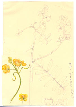
Parte de Olive Pink Collection
Pencil drawing on card with small water colour attached. Painted and sketched by Olive Pink at the Finke 31/8/30. Identified by Olive Pink as Cassia sturtii "usually 7 pairs of leaves on leaf stem - shrub about 3ft high"
Olive Pink
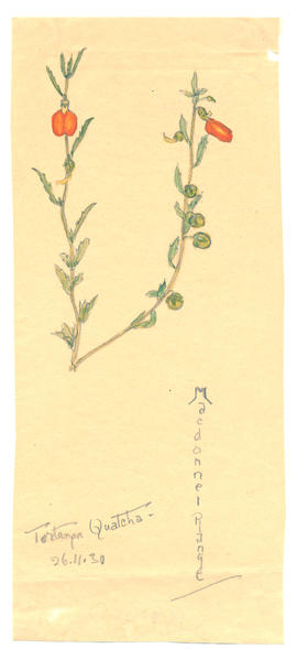
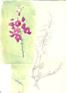
Parte de Olive Pink Collection
Pencil and watercolour on paper sketched by Olive Pink, Tortanga Quatcha, Macdonnel Range, Northern Territory, 26/11/30. Identified by Olive Pink as Jonidium
Olive Pink
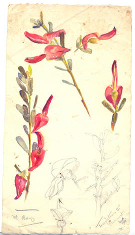
Parte de Olive Pink Collection
Watercolour and pencil on card sketched by Olive Pink, Claremont, Western Australia, 1912. Identified by Olive Pink as Tempeltonia
Olive Pink
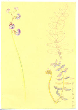
Parte de Olive Pink Collection
Watercolour and pencil on card sketched by Olive Pink, "Near Farina", 21/8/31. Identified by Olive Pink as Swainsona
Olive Pink
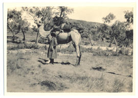
Photograph of Olive Pink and the the camel Quart-pot
Parte de Olive Pink Collection
Black and white photograph of Olive Muriel Pink standing next to a camel, 'Quart-Pot', in Central Australia, 1934, with inscription on the back by Olive Pink, '"Quart-pot" and Olivia - (ready for anything!)' Photographs sent with a letter to her friend Joan Walker in Hobart, Tasmania.
Olive Pink
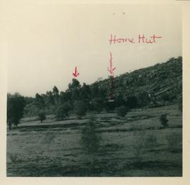
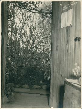
Arid Regions Native Flora Reserve - photograph
Parte de Olive Pink Collection
One of eight annotated black and white photographs of the site of the Arid Regions Native Flora Reserve. Noting the location of Home Hut.
Olive Pink
Parte de Mitchell Papers
Diary of Sarah E.E. Mitchell of Lisdillon on the East Coast of Tasmania from January 1872 - December 1873. From the age of thirteen she daily noted in her journal the state of the weather, her routine activities about the house and property and visits of friends.
Sarah E.E. Mitchell
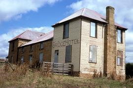
Parte de Greg Dickens Photographic Collection
Colour landscape photograph shows exterior of derelict Bridge Hotel at Ouse, situated in the crook of the Ouse River, a sandstone, weatherboard and tin structure, with windows boarded up
Parte de Olive Pink Collection
Pencil, some coloured on paper sketched by Olive Pink, 58 miles from Darwin, Northern Territory 26/10/30. Identified by Olive Pink as native cotton - " lemon hybiscus like flowers- naturalised cotton - thought not indigenous?"
Olive Pink
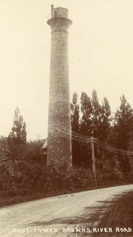
The Shot Tower, Brown's River Road
Parte de George Musgrave Parker : Correspondence and research records
H.H. Baily postcard of the Shot Tower, Browns River Road, showing the telegraph lines
George Musgrave Parker
Construction of new Risdon wharf
Black-and-white photograph shows construction of wharf at E.Z. Co. Zinc Works at Risdon
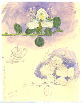
Parte de Olive Pink Collection
Coloured pencil on paper sketched by Olive Pink at Callanna Reservoir, South Australia 20-21/7/30. Identified by Olive Pink as Lavatera plebeia
Olive Pink
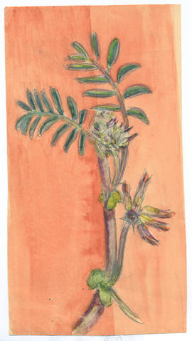
Parte de Olive Pink Collection
Water colour and pencil on paper sketched by Olive Pink, Jay Creek, Northern Territory 26/12/30. Identified by Olive Pink as Capparis
Olive Pink
Parte de Olive Pink Collection
Water colour on card sketched by Olive Pink, (place and date unknown) Northern Territory. Not identified by Olive Pink
Olive Pink
Parte de Olive Pink Collection
Watercolour and pencil on card sketched by Olive Pink, Mt. Tambourine, Queensland, 1926. Not identified by Olive Pink
Olive Pink
Photograph of the schoolhouse - front view
Parte de Photographic reproduction collection
Photograph of the front view of the schoolhouse, Broadmarsh, Tasmania. Taken April 1960
Parte de Hal Wyatt Collection
Colour photograph shows snow on mountains in Tasmania’s Central Highlands
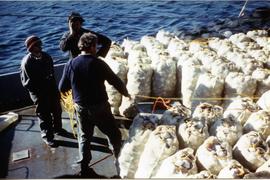
Bags of scallops on deck of fishing boat
Large number of bags filled with scallops on deck of boat with three men looking on
Graeme Raphael
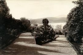
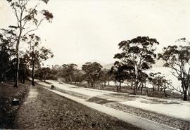
Walking path in Royal Botanical Gardens
Parte de Photographs of Edward Verrell
Black-and-white photograph shows gravel walking path in Royal Botanical Gardens

Parte de Arthur Knight Slides
Colour photograph shows waves and white caps on the surface of Lake Myrtle GIS: Latitude -4188 Longitude 14618 Gazetteer Australia Record_ID TAS02073

Shoreline of Lake Chalice 1979
Parte de Arthur Knight Slides
Colour photograph shows the rocky shoreline of Chalice Lake GIS: Latitude -4188 Longitude 14615 Gazetteer Australia Record_ID TAS02044

Reflections upon surface of Lake Chalice 1979
Parte de Arthur Knight Slides
Colour photograph shows reflections of alpine vegetation in Chalice Lake 1979 GIS: Lake Latitude -4188 Longitude 14615 Gazetteer Australia Record_ID TAS02044

Lake Loane under snow cover 1978
Parte de Arthur Knight Slides
Colour photograph shows Lake Loane beneath blanket of snow, from near the Horse Track 1978

Lake Lea from Prospect Mountain
Parte de Arthur Knight Slides
Colour photograph shows Lake Lea from Prospect Mountain near Vale of Belvoir

Parte de Arthur Knight Slides
Colour photograph shows shoreline of Lake Adelaide

Parte de Arthur Knight Slides
Colour photograph of limited water flow across Knyvet Falls 1984 GIS: Latitude -4159 Longitude 14593 Gazetteer Australia Record_ID TAS06008

Parte de Arthur Knight Slides
Colour photograph shows snow at Jaffa Vale

Snowfall at Jaffa Vale and Mount Olympus
Parte de Arthur Knight Slides
Colour photograph shows tracks of snow skiers at Jaffa Vale and Mount Olympus
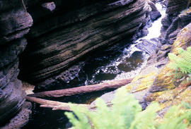
Water flowing in base of Leven Canyon
Parte de Arthur Knight Slides
Colour photograph shows logs in base of Leven Canyon

Knyvet Falls near Cradle Mountain
Parte de Greg Dickens Photographic Collection
Colour photograph shows water flowing over Knyvet Falls in the Cradle Valley
Parte de Photographs of Edward Verrell
Black-and-white photograph shows stone buildings along Salamanca Place, timber stacked on New Wharf and masts of ships docked at the wharf; signs on buildings for “A.E. Lord Wool Merchant” and “W.D. Peacock and Co.”, historic home Lenna and eastern conservatory visible on hilltop behind towards Battery Point; maritime signal station with the Time Ball that was dropped automatically at 1pm, after a relayed telegraph signal from the Melbourne Observatory.
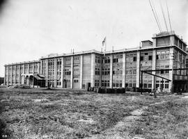
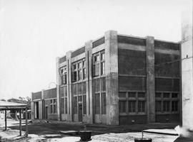
Large multi-storied building forming part of the Cadbury factory under construction. Wooden barrels can be seen on grass in front.
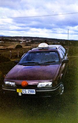
Ford taxi cab, marked Car 1309, Area 2. Car sporting red plastic nose, possibly in support of Red Nose Day which aims to raise awareness of SIDS
Graeme Raphael
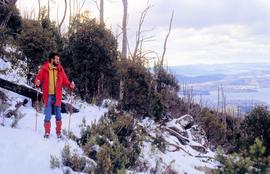
Parte de Hal Wyatt Collection
Colour photograph of man looking down Mount Wellington, with skis, from Milles Track
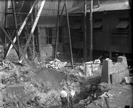
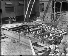
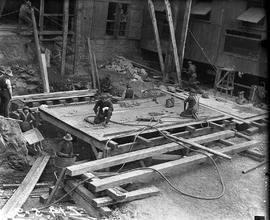
Excavation for Derwent Prime furnace at E.Z. Co. Zinc Works
Black-and-white photograph shows workmen digging earth and rubble to be loaded into a horse-drawn cart at excavation site for new Derwent Prime furnace being built at E.Z Co. Zinc Works 1930
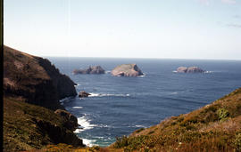
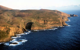
View of the Friars from shore near Pine Log Bight
Parte de Arthur Knight Slides
Colour photograph of the Friars, a small group of islands, off southern shore of Bruny Island, taken from shore near Pine Log Bight.

Parte de Arthur Knight Slides
Colour photograph shows icicles formed on Little Horn 1985

Ice formation near Herods Gate 1978
Parte de Arthur Knight Slides
Colour photograph shows ice formation on cliff face near Herods Gate, with snow covering alpine vegetation

Parte de Arthur Knight Slides
Colour photograph shows ice formed on plants, location unknown

Parte de Arthur Knight Slides
Colour photograph shows hut at Lake Meston built of logs, shingles and with tin plate chimney People sitting outside hut eating

Snow on banks of River Derwent 1986
Parte de Arthur Knight Slides
Colour photograph shows snow on the shoreline of River Derwent 1986

Parte de Arthur Knight Slides
Colour photograph shows Grail Falls

Wildflowers on Cathedral Mountain
Parte de Arthur Knight Slides
Colour photograph of wildflower in alpine environment
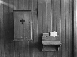
Wooden first aid cupboard and small shelf attached to wood panelled wall in the Cadbury factory at Claremont.
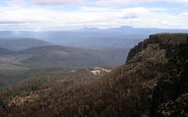
View towards Barn Bluff and Cradle Mountain from Devils Gullet
Parte de Greg Dickens Photographic Collection
Colour photograph shows view from Devils Gullet Lookout towards Cradle Mountain and Barn Bluff with earthworks surrounding Fisher Power Station on hill in foreground
Photograph of Braeside from the south west
Parte de Photographic reproduction collection
Photograph of Braeside from the South West, Broadmarsh. Taken April 1960. Now known as Stonefield' , 'Braeside' was built in 1824, located at 266 Elderslie Rd, Lower Broadmarsh. A good example of a two storey Georgian home with a separate kitchen wing
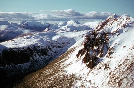
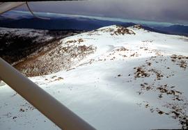
Aerial view of northern end of Denison Range
Parte de Hal Wyatt Collection
Colour aerial photograph of rocky peaks of Denison Range, partially covered in snow
Road to Government House, on Gun Carriage Drive
Parte de Photographs of Edward Verrell
Black-and-white photograph taken looking north along Gun Carriage Drive towards Government House, Hobart, with post-and-rail fences on Derwent River side; a horse harnessed to a four-wheel carriage, is on the left of the road; a small jetty extends from the shoreline and a boat is visible through the trees, anchored just off shore.
Staging for Derwent Prime furnace jacket at E.Z. Co. Zinc Works
Black-and-white photograph shows men building staging for Derwent Prime furnace at E.Z. Co. Zinc Works at Risdon
Setting sun shines on headland east of Cloudy Bay
Parte de Arthur Knight Slides
Colour photograph of headland east of Cloudy Bay, illuminated by low setting sun.
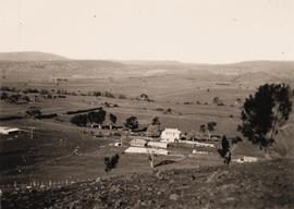
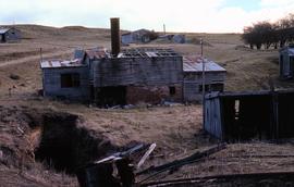
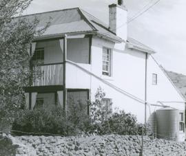
Black and white photograph taken from hillside, looking down on two-storey house with numerous outbuildings. Fenced paddocks visible.
Graeme Raphael

Parte de Arthur Knight Slides
Colour photograph shows Volkswagen combi van being driven through floodwaters across Midland Highway 1964

Parte de Arthur Knight Slides
Colour photograph shows alpine plateau, valley and Eldon and Tyndall ranges in distance
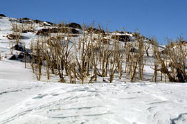
Dead alpine trees in snow at Wailing Wall
Parte de Arthur Knight Slides
Colour photograph shows impact of bushfire that left dead vegetation in an alpine area at the Wailing Wall

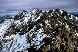
Du Cane Range and Mount Ossa under snow
Parte de Arthur Knight Slides
Colour photograph of Du Cane Range and Mount Ossa

Du Cane Range from Mountains of Jupiter
Parte de Arthur Knight Slides
Colour photograph shows Du Cane Range as viewed from Mountains of Jupiter

Parte de Arthur Knight Slides
Colour photograph shows two sets of skis and backpacks outside an alpine hut, covered in a snowdrift

Alpine hut covered in snowdrift
Parte de Arthur Knight Slides
Colour photograph shows footprints in snow leading to an alpine hut in a clearing, partially covered by snowdrift

Parte de Arthur Knight Slides
Colour photograph shows bed of green and red cushion plants
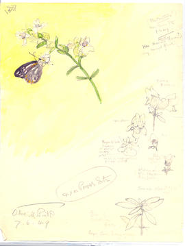
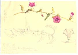
Parte de Olive Pink Collection
Identified as Prostanthera striatiflora . Watercolor on card sketched by Olive Pink near power station at Alice Springs on 7 June 1958
'has aromatic scent (leaves?) (very honeyed flower)
Olive Pink
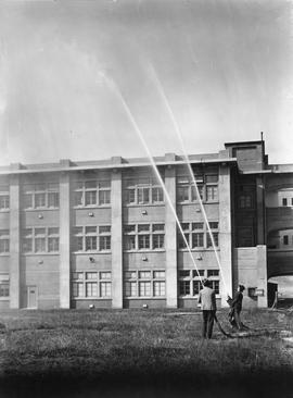
Two men spraying plumes of water into the air from high pressure fire hoses.
Low sun at Meadsfield near Bothwell
Parte de Greg Dickens Photographic Collection
Colour photograph shows hilltop and lightly timbered landscape at Meadsfield near Bothwell, photographed in evening sunlight
Photograph of farmhouse in rural setting, Verandah appears to be glassed in on at least two sides/
Graeme Raphael
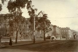
Public buildings near Franklin Square, Hobart
Parte de Photographs of Edward Verrell
Black-and-white photograph shows public buildings near Franklin Square, Hobart
Workers assembling base of furnace jacket at E.Z. Co. Zinc Works
Black-and-white photograph shows men assembling bottom jacket of Derwent Prime furnace at E.Z. Co. Zinc Works at Risdon
Parte de Photographic reproduction collection
Photograph of the front door of Roydon, Broadmarsh. Taken April 1960. Located at 58 Clifton Vale Road, Elderslie. Sandstone farm house with a central door and flanking double hung windows, an attic level and weatherboard addition to the rear. The building has a hipped roof and narrow boxed eaves. The sandstone stables feature a half hipped roof, sandstone walls and an iron roof. The building is a floor and a half and is still in use as a stable. There are some other early buildings on the site.
Skiers on Mount Mawson plateau
Parte de Hal Wyatt Collection
Colour aerial photograph of Mount Mawson ski field with skiers visible

Staircase in Bruny Island Lighthouse
Parte de Arthur Knight Slides
Colour photograph taken inside Bruny Island Lighthouse showing metal staircase

Parte de Arthur Knight Slides
Colour photograph shows bed of green cushion plants

Parte de Arthur Knight Slides
Colour photograph shows a steel-plated culvert beneath a road at Foggs Flat

Parte de Arthur Knight Slides
Colour photograph shows shoreline of Crater Lake with sunlit cliffs on opposite bank

Parte de Arthur Knight Slides
Colour photograph shows Crater Lake

Pencil Pines on shore of Crater Lake
Parte de Arthur Knight Slides
Colour photograph shows Crater Lake, with remnants of snow on rock ledge

Parte de Arthur Knight Slides
Colour photograph shows ridge of rock from Dove Lake

Cradle Mountain from Hansons Peak
Parte de Arthur Knight Slides
Colour photograph of Cradle Mountain as viewed from nearby Hansons Peak

View of Cradle Mountain ridgeline from Hansons Peak
Parte de Arthur Knight Slides
Colour photograph of Cradle Mountain from Hansons Peak

Reflection of mountain on surface of Dove Lake
Parte de Arthur Knight Slides
Colour photograph shows light dusting of snow on Cradle Mountain, visible also from reflection in Dove Lake in foreground