Aerial view of cars choking road near Baskerville race track
- AU TAS UTAS ITCCD 2017/2-225
- Item
Parte de Arthur Knight Slides
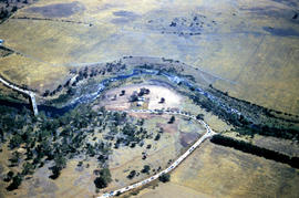
Colour aerial photograph shows cars travelling to Baskerville Raceway, which opened in 1958

Aerial view of cars choking road near Baskerville race track
Parte de Arthur Knight Slides
Colour aerial photograph shows cars travelling to Baskerville Raceway, which opened in 1958
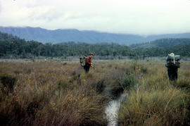
Walkers carrying building materials to K Col
Parte de Arthur Knight Slides
Colour photograph shows walkers carrying building materials to build a hut to shelter bushwalkers
Parte de Arthur Knight Slides
Colour photograph shows the rusting red roofing iron on hut visible above trees on the edge of Twilight Tarn
Parte de Arthur Knight Slides
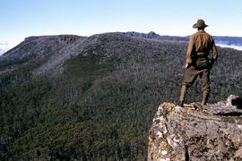
Colour photograph shows man in red and black check bush shirt standing in bush on Mount Lord, looking west. Man is standing amid tall specimens of Pandani, Richea pandanifolia
Parte de Arthur Knight Slides
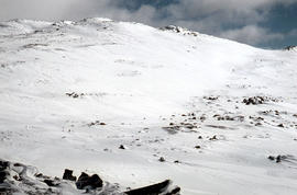
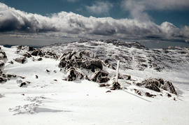
Colour photograph shows snow-covered slope on Ben Lomond
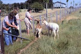
Visitors feeding fallow deer at Thorpe Farm, Bothwell
Parte de Greg Dickens Photographic Collection
Colour photograph shows deer being offered food by visitors to Thorpe Farm, where fallow deer is farmed by the Bignell family, Bothwell.
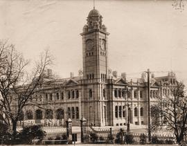
Hobart GPO before installation of clock in tower
Parte de Photographs of Edward Verrell
Black-and-white photograph shows Hobart General Post Office viewed from Franklin Park before the installation of the clock in the clocktower.
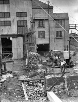
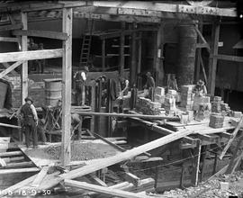
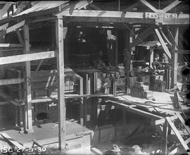
Workmen preparing footings for expansion at E.Z. Co. Zinc Works at Risdon
Black-and-white photograph depicts workmen preparing footings for expansion of power house at E.Z. Co. Zinc Works at Risdon
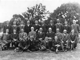
Group of men wearing suits and ties posing for photograph on lawn.
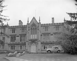
Domain House, a neo-Gothic sandstone building in Hobart.
Graeme Raphael
View of Mount Field West from Florentine Peak
Parte de Hal Wyatt Collection
Colour photograph of Mount Field West from Florentine Peak 1966
Aftermath of blizzard on Ben Lomond
Parte de Arthur Knight Slides
Colour photograph shows snow on the upper slopes of Ben Lomond after a blizzard
Parte de Arthur Knight Slides
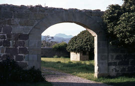
Colour photograph of stone archway at Bona Vista estate at Avoca, with view of mountains in the background Source: https://ehivecom/collections/4357/objects/180139/bona-vista-avoca-tasmania
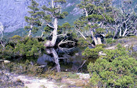
Trees reflected in Artists Pool
Parte de Arthur Knight Slides
Colour photograph of Artists Pool, a waterhole near Cradle Mountain, with reflections of alpine plants on the water's surface

Parte de Arthur Knight Slides
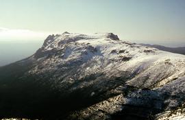
Colour photograph of Bare Mountain, with evidence of past bushfire damage to trees on lower slope GIS: Latitude -4149 Longitude 14590 Gazetteer Australia Record_ID TAS23466

Parte de Arthur Knight Slides
Colour photograph shows a person pointing at a dead bird on the ground near Bare Mountain, with new undergrowth shooting after a recent bushfire and several bushwalkers visible in the distance
Parte de Arthur Knight Slides
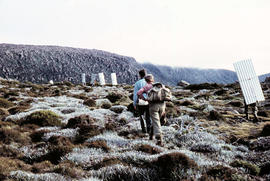
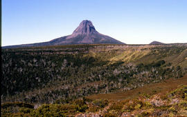
Colour photograph of Barn Bluff and Cradle Cirque

Parte de Arthur Knight Slides
Colour photograph of two walkers trying to avoid slippery pathway with flecks of snow on ground and Barn Bluff in background

Barn Bluff as viewed from Cradle Mountain
Parte de Arthur Knight Slides
Colour photograph of Barn Bluff as viewed form Cradle Mountain with some snow remaining on the ridgelines of the cirque
Parte de Arthur Knight Slides
Colour photograph shows heavy snow cover on Mount Barrow with man carrying skis next to guideposts alongside road

Parte de Arthur Knight Slides
Colour photograph shows open paddock and mature eucalypt trees with Ben Lomond in the distance
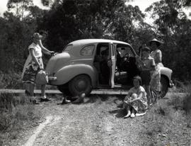
Occupants of motor vehicle step outside car on bush track
Group of women and children wearing casual summer clothing, standing around a car parked on side of a dirt road. Reminiscent of a picnic trip.
Graeme Raphael
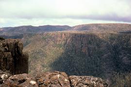
View from Devils Gullet lookout
Parte de Greg Dickens Photographic Collection
Colour photograph shows view from Devils Gullet Lookout off Lake McKenzie Road
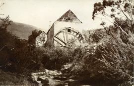
Water mill on New Town Rivulet
Parte de Photographs of Edward Verrell
Black-and-white photograph shows water wheel on outside of mill on New Town Rivulet at Lenah Valley
Construction of furnace at E.Z. Co. Zinc Works
Black-and-white photograph shows workmen building the Derwent Prime furnace at E.Z. Co. Zinc Works at Risdon
Man looking to Mount Marian from Mount Charles
Parte de Hal Wyatt Collection
Colour photograph of man standing on ledge of Mount Charles looking towards Mount Marian. Man wearing brown felt hat, leather chaps and woollen shirt
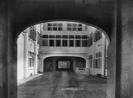
Internal Courtyard, Cadbury Factory
View of road through an internal courtyard, surrounded by multi-storied factory buildings on Cadbury site.
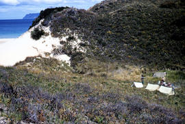
View of Bruny Island campsite of Hobart Walking Club 1955
Parte de Arthur Knight Slides
Colour photograph of heath and sand dunes, site of Hobart Walking Club campsite near Cape Queen Elizabeth on Bruny Island,1955
Parte de Arthur Knight Slides
Colour photograph shows snow on Ben Lomond

Parte de Arthur Knight Slides
Colour photograph of Carr Villa ski lodge at base of Ben Lomond
Parte de Arthur Knight Slides
Colour photograph shows Ben Lomond plateau with partial snow cover and blackened ground
Parte de Arthur Knight Slides
Colour photograph of snow skiers on Ben Lomond
Parte de Arthur Knight Slides
Colour photograph shows open farmland in the foothills of Ben Lomond

Black jay perches on dozer at Cradle Mountain
Parte de Arthur Knight Slides
Colour photograph shows a black jay perched on exhaust pipe of a John Deere earthmoving machinery near Waldheim Chalet car park at Cradle Mountain
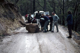
Boulder blocks Storeys Creek Rd 1964
Parte de Arthur Knight Slides
Colour photographs shows motorists trying to clear a boulder from Storeys Creek Road after a rock fall
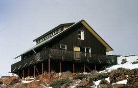
Carr Villa Chalet at Ben Lomond 1962
Parte de Arthur Knight Slides
Colour photograph shows two people inspecting a gas cylinder outside the Carr Villa Chalet atop the treeline at Ben Lomond

Central Highlands from cirque ridgeline
Parte de Arthur Knight Slides
Colour photograph shows mountains from the Cirque near Cradle Mountain

Central Highlands from Cradle Mountain
Parte de Arthur Knight Slides
Colour photograph shows mountains of Central Highlands as viewed from Cradle Mountain
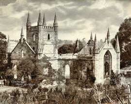
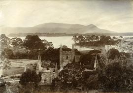
Ruins of church at Port Arthur
Parte de Photographs of Edward Verrell
Black-and-white photograph shows ruins of the church at Port Arthur, damaged by fire in 1884,with charred timber framework in the roof, remnant shingles on the roof and climbing plants covering the sandstone of the church walls. Handwritten words “Church at Port Arthur” in lower left corner of image.
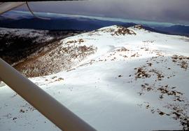
Aerial view of Mount Mawson 1970
Parte de Hal Wyatt Collection
Colour aerial photograph of Mount Mawson under snow cover
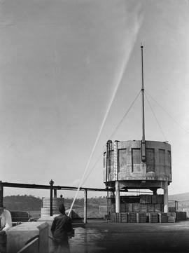
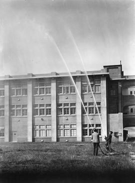
High Pressure Hose, Cadbury Factory
Large cement tank being sprayed with water by man holding high pressure fire hose.
Parte de Greg Dickens Photographic Collection
Colour photograph shows view from Devils Gullet Lookout
Section of old bridge at Alonnah
Parte de Arthur Knight Slides
Colour photograph of old Hobart Bridge section tethered offshore at Alonnah
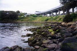
Eastern Shore near Tasman Bridge
View of portion of Hobart's Eastern Shore with water in foreground and the on/off ramp to bridge.
Graeme Raphael
Bricklayers building furnace at E.Z. Co. Zinc Works
Black-and-white photograph shows bricklayers and men working on Derwent Prime furnace at E.Z. Co. Zinc Works at Risdon

Chalice Lake and Mount Rogoona
Parte de Arthur Knight Slides
Colour photograph of Chalice Lake and Mount Rogoona GIS: Latitude -4188 Longitude 14619 Gazetteer Record_ID TAS02032

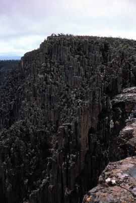
Parte de Arthur Knight Slides
Colour photograph shows cliffs near Stacks Bluff

Parte de Arthur Knight Slides
Colour photograph shows shoreline of Cloister Lagoon GIS: Latitude -4189 Longitude 14617 Gazetteer Australia Record_ID TAS02046

Misty morning at Cloister Lagoon
Parte de Arthur Knight Slides
Colour photograph shows mist above the surface of Cloister Lagoon just before daybreak

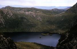
Looking south to Cradle Mountain
Parte de Arthur Knight Slides
Colour photograph shows the heathland on the Central Plateau, south of Cradle Mountain, with the mountain peaks visible in the distance

Parte de Arthur Knight Slides
Colour photograph shows flecks of snow on upper ridges of Cradle Mountain and land around Dove Lake, some of it cloaked in deep shadow

Reflection of mountain on still surface of Dove Lake
Parte de Arthur Knight Slides
Colour photograph shows reflection of Cradle Mountain on surface of Dove Lake Image of mountain slightly out of focus

Parte de Arthur Knight Slides
Colour photograph shows Lake Lea in foreground, with Cradle Mountain and Barn Bluff in distance

Cradle Mountain from Dove Lake
Parte de Arthur Knight Slides
Colour photograph shows light dusting of snow on Cradle Mountain from Dove Lake
View of Dove Lake and Honeymoon Island
Parte de Greg Dickens Photographic Collection
Colour photograph shows Honeymoon Island in Dove Lake, near Cradle Mountain
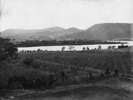
Orchard on the bank of the Derwent River with Cadbury factory in background.
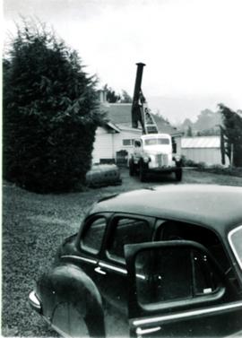
Truck-mounted crane hoists chimney into place
Black and white photograph. Small crane truck being used to position a chimney on the roof of a building.
Graeme Raphael
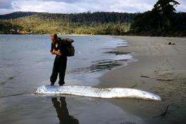
Man inspects ribbon fish on beach
Parte de Arthur Knight Slides
Colour photograph of man looking at ribbonfish washed up on beach at Adventure Bay, Bruny Island

Workers assembling jacket of Derwent Prime furnace at E.Z. Co. Zinc Works
Black-and-white photograph shows men assembling sides and ends of jacket of Derwent Prime furnace at E.Z. Co. Zinc Works at Risdon

Parte de Hal Wyatt Collection
Colour photograph of people skiing at Mount Mawson
Elevated view of church ruins at Port Arthur
Parte de Photographs of Edward Verrell
Black-and-white photograph shows elevated view of ruined church at Port Arthur, including charred timber roof framework; with view of waterfront and other buildings on Port Arthur site; cut hay is drying in paddock at front of church.

Reflection of mountain on surface of Dove Lake
Parte de Arthur Knight Slides
Colour photograph shows light dusting of snow on Cradle Mountain, visible also from reflection in Dove Lake in foreground

View of Cradle Mountain ridgeline from Hansons Peak
Parte de Arthur Knight Slides
Colour photograph of Cradle Mountain from Hansons Peak

Cradle Mountain from Hansons Peak
Parte de Arthur Knight Slides
Colour photograph of Cradle Mountain as viewed from nearby Hansons Peak

Parte de Arthur Knight Slides
Colour photograph shows ridge of rock from Dove Lake
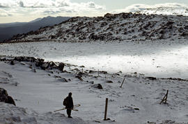
Snow cover on Ben Lomond Plateau
Parte de Arthur Knight Slides
Colour photograph shows snow cover on Ben Lomond Plateau

Pencil Pines on shore of Crater Lake
Parte de Arthur Knight Slides
Colour photograph shows Crater Lake, with remnants of snow on rock ledge

Parte de Arthur Knight Slides
Colour photograph shows Crater Lake

Parte de Arthur Knight Slides
Colour photograph shows shoreline of Crater Lake with sunlit cliffs on opposite bank

Parte de Arthur Knight Slides
Colour photograph shows a steel-plated culvert beneath a road at Foggs Flat

Parte de Arthur Knight Slides
Colour photograph shows bed of green cushion plants
Two men spraying plumes of water into the air from high pressure fire hoses.
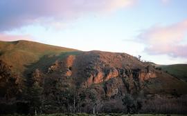
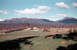
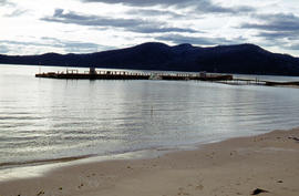
Low sun at Meadsfield near Bothwell
Parte de Greg Dickens Photographic Collection
Colour photograph shows hilltop and lightly timbered landscape at Meadsfield near Bothwell, photographed in evening sunlight
Photograph of farmhouse in rural setting, Verandah appears to be glassed in on at least two sides/
Graeme Raphael
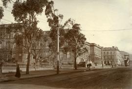
Public buildings near Franklin Square, Hobart
Parte de Photographs of Edward Verrell
Black-and-white photograph shows public buildings near Franklin Square, Hobart
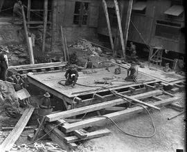
Workers assembling base of furnace jacket at E.Z. Co. Zinc Works
Black-and-white photograph shows men assembling bottom jacket of Derwent Prime furnace at E.Z. Co. Zinc Works at Risdon
Skiers on Mount Mawson plateau
Parte de Hal Wyatt Collection
Colour aerial photograph of Mount Mawson ski field with skiers visible

Staircase in Bruny Island Lighthouse
Parte de Arthur Knight Slides
Colour photograph taken inside Bruny Island Lighthouse showing metal staircase

Parte de Arthur Knight Slides
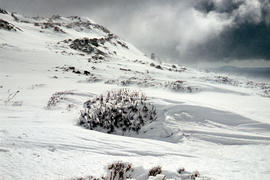
Colour photograph shows bed of green and red cushion plants

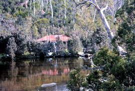
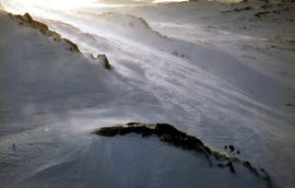
Alpine hut covered in snowdrift
Parte de Arthur Knight Slides
Colour photograph shows footprints in snow leading to an alpine hut in a clearing, partially covered by snowdrift

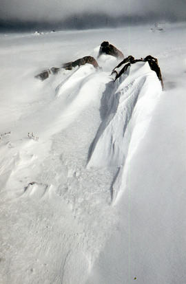
Parte de Arthur Knight Slides
Colour photograph shows two sets of skis and backpacks outside an alpine hut, covered in a snowdrift
Parte de Arthur Knight Slides
Colour photograph shows wind moving snow in drift at sunset on Ben Lomond 1962
Snowdrift against rocks at Ben Lomond
Parte de Arthur Knight Slides
Colour photograph shows snowdrift against rocks on Ben Lomond 1962

Du Cane Range from Mountains of Jupiter
Parte de Arthur Knight Slides
Colour photograph shows Du Cane Range as viewed from Mountains of Jupiter

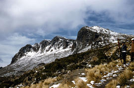
Du Cane Range and Mount Ossa under snow
Parte de Arthur Knight Slides
Colour photograph of Du Cane Range and Mount Ossa
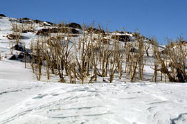
Dead alpine trees in snow at Wailing Wall
Parte de Arthur Knight Slides
Colour photograph shows impact of bushfire that left dead vegetation in an alpine area at the Wailing Wall

Parte de Arthur Knight Slides
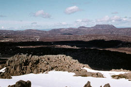
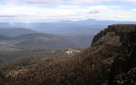
Colour photograph shows alpine plateau, valley and Eldon and Tyndall ranges in distance

Parte de Arthur Knight Slides
Colour photograph shows Volkswagen combi van being driven through floodwaters across Midland Highway 1964
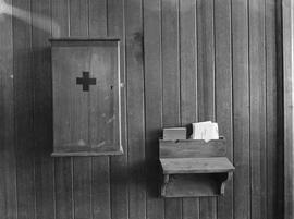
Wooden first aid cupboard and small shelf attached to wood panelled wall in the Cadbury factory at Claremont.
View towards Barn Bluff and Cradle Mountain from Devils Gullet
Parte de Greg Dickens Photographic Collection
Colour photograph shows view from Devils Gullet Lookout towards Cradle Mountain and Barn Bluff with earthworks surrounding Fisher Power Station on hill in foreground
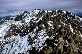
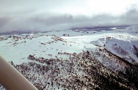
Aerial view of northern end of Denison Range
Parte de Hal Wyatt Collection
Colour aerial photograph of rocky peaks of Denison Range, partially covered in snow
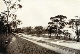
Road to Government House, on Gun Carriage Drive
Parte de Photographs of Edward Verrell
Black-and-white photograph taken looking north along Gun Carriage Drive towards Government House, Hobart, with post-and-rail fences on Derwent River side; a horse harnessed to a four-wheel carriage, is on the left of the road; a small jetty extends from the shoreline and a boat is visible through the trees, anchored just off shore.
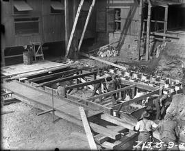
Staging for Derwent Prime furnace jacket at E.Z. Co. Zinc Works
Black-and-white photograph shows men building staging for Derwent Prime furnace at E.Z. Co. Zinc Works at Risdon
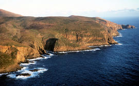
Setting sun shines on headland east of Cloudy Bay
Parte de Arthur Knight Slides
Colour photograph of headland east of Cloudy Bay, illuminated by low setting sun.
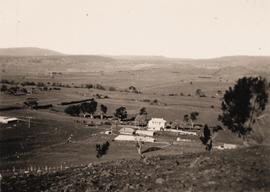
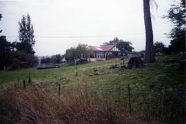
Black and white photograph taken from hillside, looking down on two-storey house with numerous outbuildings. Fenced paddocks visible.
Graeme Raphael

Wildflowers on Cathedral Mountain
Parte de Arthur Knight Slides
Colour photograph of wildflower in alpine environment
Parte de Arthur Knight Slides
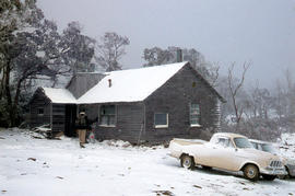
Colour photograph shows Foresters hut on Ben Lomond 1977
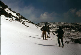
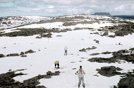
Parte de Arthur Knight Slides
Colour photograph shows three snow skiers on Ben Lomond 1977

Parte de Arthur Knight Slides
Colour photograph shows Grail Falls

Snow on banks of River Derwent 1986
Parte de Arthur Knight Slides
Colour photograph shows snow on the shoreline of River Derwent 1986