
- AU TAS UTAS ITCCD 2017/1-409
- Item
- c1910
Part of Images of West Coast Tasmania
Image is likely sourced from a newspaper or publication as it is grainy and contains printed legend at the bottom: Old Court House, Sarah Island
8492 results with digital objects Show results with digital objects
Part of Images of West Coast Tasmania
Image is likely sourced from a newspaper or publication as it is grainy and contains printed legend at the bottom: Old Court House, Sarah Island
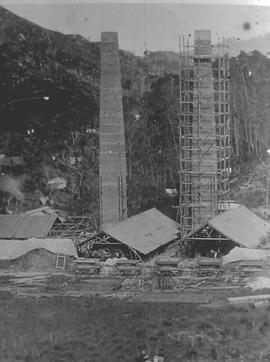
View of smelters at Crotty, Tasmania.
Part of Images of West Coast Tasmania
Image shows one chimney stack under scaffolding and other buildings under construction.
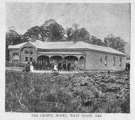
Image shows the Crotty Hotel with people in front. Crotty, Tasmania.
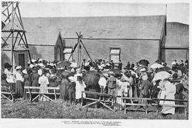
Part of Images of West Coast Tasmania
Image likely sourced from a newspaper or publication as it contains printed legend at the bottom: Opening out of the west - clearing the land for the new town of Crotty. Photographer identified. Primitive buildings just visible in the background. It is likely the image is older than 1902.
Part of Images of West Coast Tasmania
Image is likely sourced from a newspaper or publication as it shows legend at the bottom identifying the scene and photographer.
Colin Dennison
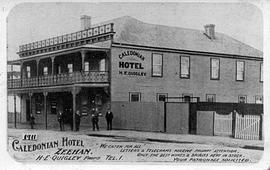
View of the Caledonian Hotel, Zeehan, Tasmania
Part of Images of West Coast Tasmania
Image is likely an advertising card as text is printed on the image providing details of services, address and proprietors name. An additional label giving the date has been added to the image later.
View of the former Commercial Bank, Zeehan, Tasmania
Part of Images of West Coast Tasmania
Image shows the building in a state of disrepair with windows boarded.
Part of Olive Pink Collection
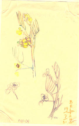
Coloured pencil drawing sketched by Olive Pink, Beltana, South Australia 17/7/30. Identified by Olive Pink as Acacia salicina
Olive Pink
Part of Olive Pink Collection
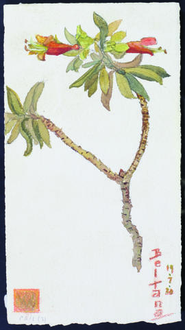
Watercolour painted by Olive Pink at Beltana, South Australia 19/7/30. Identified by Olive Pink as Eremophila maculata
Olive Pink
Part of Olive Pink Collection
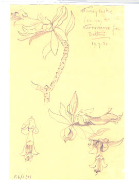
Pencil drawing sketched by Olive Pink, Beltana, South Australia 19/7/30.
Olive Pink
Edwards Creek, South Australia and Wire Creek
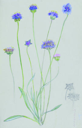
Part of Olive Pink Collection
25 sketches, pencil and crayon, a few water coloured
Olive Pink
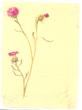
Part of Olive Pink Collection
Watercolour on paper, painted by Olive Pink at Edwards Creek, South Australia, 30/7/30. Identified by Olive Pink as Centaurea
Olive Pink
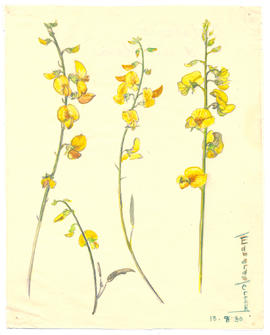
Part of Olive Pink Collection
Coloured pencil on card sketched by Olive Pink at Edwards Creek, South Australia (no date). Identified by Olive Pink as Tribulus (Bindii)
Olive Pink
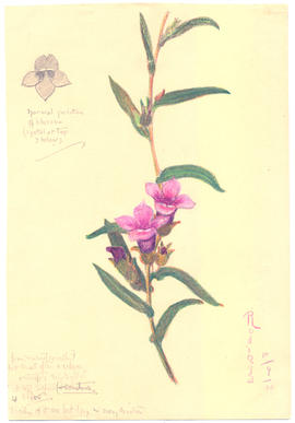
Part of Olive Pink Collection
Watercolour on paper painted by Olive Pink at Edwards Creek, South Australia, 13/8/30. Identified by Olive Pink as Crotalaria dissitiflora
Olive Pink
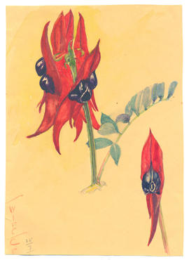
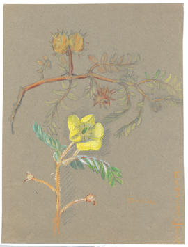
Part of Olive Pink Collection
Watercolour on card painted by Olive Pink at Wire Creek, South Australia 25/7/30. Identified by Olive Pink as Clianthus speciosum
Olive Pink
Part of Olive Pink Collection
5 sketches
Olive Pink
Part of Olive Pink Collection
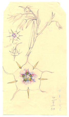
Watercolour and pencil on paper sketched by Olive Pink at the The Finke, Northern Territory 4/9/30. "natural size"
Olive Pink
Horseshoe Bend, Northern Territory
Part of Olive Pink Collection
11 sketches
Olive Pink
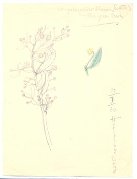
Part of Olive Pink Collection
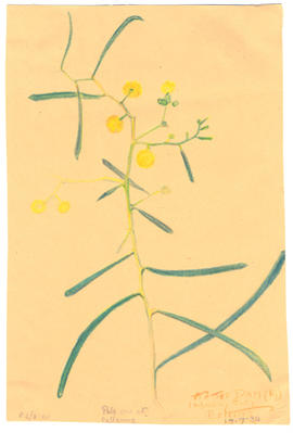
Pencil on paper, sketched by Olive Pink at Horseshoe Bend, Central Australia 12/7/30. "Very pale yellow blossom (wattle) - blue green leaves"
Olive Pink
Part of Olive Pink Collection
Watercolour and pencil on light green card sketched by Olive Pink at Rodinga, Northern Territory 13/9/30. Identified by Olive Pink as Brunonia australis (Goodeniaceae)
Olive Pink
Part of Olive Pink Collection
Pencil and crayon on card, sketched by Olive Pink at Rodinga, Northern Territory 28/9/30. "from nature (exactly) but most often a creeper and therefore simple petal at top)+ sometimes 4 below - trails of it are feet long in every direction" "normal position of blossom (1 petal at top 3 below)"
Olive Pink

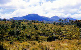
Du Cane Range from Mountains of Jupiter
Part of Arthur Knight Slides
Colour photograph shows Du Cane Range as viewed from Mountains of Jupiter

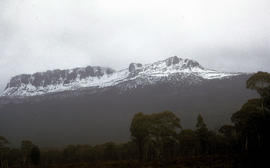
Du Cane Range and Mount Ossa under snow
Part of Arthur Knight Slides
Colour photograph of Du Cane Range and Mount Ossa

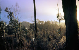
Part of Arthur Knight Slides
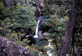
Colour photograph shows Grail Falls

Part of Arthur Knight Slides
Colour photograph shows ice formed on plants, location unknown
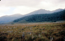
Sitting on ledge beside Leven River
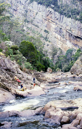
Part of Arthur Knight Slides
Colour photograph shows walkers resting on rock ledge beside Leven River in the Leven Canyon
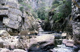
Part of Arthur Knight Slides
Colour photograph shows rockpools in the Leven River at Leven Canyon, surrounded by steep rockwalls and temperate rainforest

Part of Arthur Knight Slides
Colour portrait format photograph shows Lake Wilks and Little Horn near Cradle Mountain

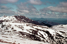
Walkers on Mountains of Jupiter
Part of Arthur Knight Slides
Colour photograph of bushwalkers at Mountains of Jupiter near the Walls of Jerusalem
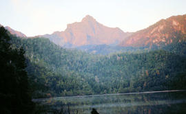
Part of Arthur Knight Slides
Colour photograph shows Mount Anne at sunrise as viewed from across Lake Timk

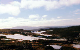
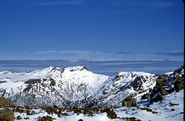
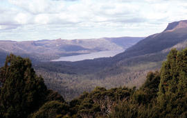
Mount Geyron from Cathedral Mountain
Part of Arthur Knight Slides
Colour photograph shows Lake Payanna and Mount Ida
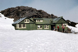
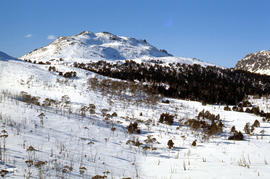
Northern Tasmanian Alpine Club hut on Ben Lomond
Part of Arthur Knight Slides
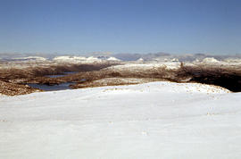
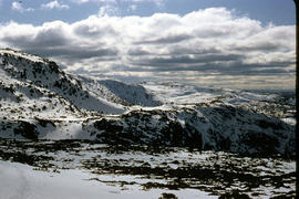
Colour photograph shows snow cover near Walls of Jerusalem looking to Mount Olympus and Mount Gould
Part of Arthur Knight Slides
Colour photograph of view from snow capped Cradle Mountain looking north
Snow cover at near Walls of Jerusalem looking to Mount Olympus and Mount Gould
Part of Arthur Knight Slides
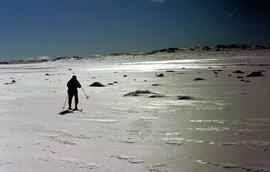
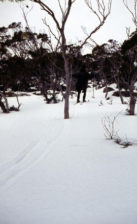
Colour photograph shows snow skier standing on Mount Jerusalem
Part of Arthur Knight Slides
Colour photograph shows whitewater section of Pencil Pine Creek
Pencil Pines near Dixons Kingdom
Part of Arthur Knight Slides
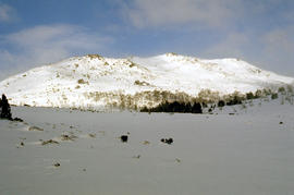
Colour photograph shows Piesse Vale at Ben Lomond plateau dusted with snow GIS Latitude -4154 Longitude 14763 Gazetteer Record_ID TAS13722
Part of Arthur Knight Slides
Colour photograph shows creek running through snow and ice on plateau above Cradle Mountain
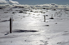
Plateau near summit of Ben Lomond
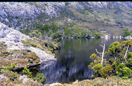
Part of Arthur Knight Slides
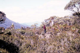
Colour photograph shows reflections of alpine vegetation in tarn near Mountains of Jupiter
Part of Arthur Knight Slides
Colour photograph shows snow covering the Pool of Siloam near The Temple below Mount Jerusalem
Part of Arthur Knight Slides
Colour photograph shows view of forest and mountain ranges from Mayday Mountain
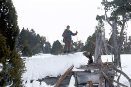
Skiing on the roof of Dixons Kingdom
Part of Arthur Knight Slides
Colour photograph shows buildings on Ben Lomond
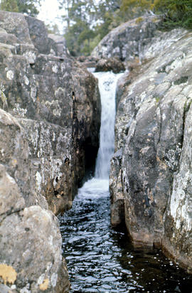
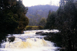
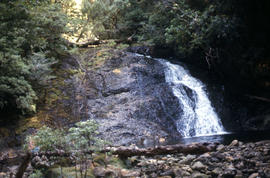
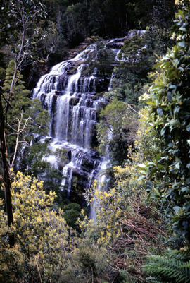
Small waterfall above Grail Falls
Part of Arthur Knight Slides
Colour photograph shows snow formation at Jaffa Gate
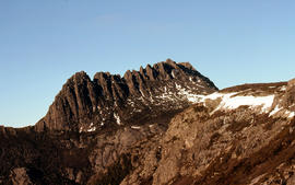
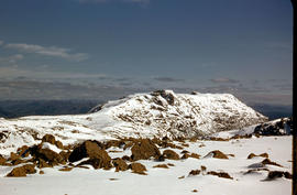
Summit of Cradle Mountain 1976
Part of Arthur Knight Slides
Colour photograph shows summit of West Wall, at Mount Jerusalem
The Temple near Mount Jerusalem
Part of Arthur Knight Slides
Colour photograph shows snow cover along the Wailing Wall near Mount Jerusalem
The Temple and Mount Jerusalem 1978
Part of Arthur Knight Slides
Colour photograph shows the Temple near Mount Jerusalem

Part of Arthur Knight Slides
Colour photograph shows alpine vegetation and snowcover below Mount Ophel
Waterfall at western end of Lake Timk 1974
Part of Arthur Knight Slides
Colour photograph shows West Wall

Part of Arthur Knight Slides
Colour photograph shows snow cover surround Lake Thor and Western Bluff
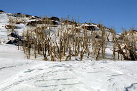
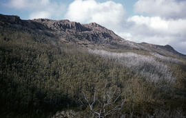
Dead alpine trees in snow at Wailing Wall
Part of Arthur Knight Slides
Colour photograph shows impact of bushfire that left dead vegetation in an alpine area at the Wailing Wall
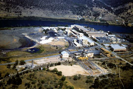
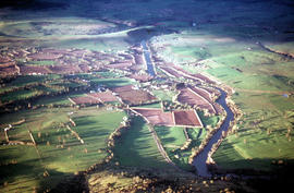
Aerial view of newsprint mill at Boyer
Part of Arthur Knight Slides
Colour photograph taken from the air, depicting Australian Newsprint Mills factory at Boyer in 1958
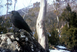
Part of Arthur Knight Slides
Colour photograph shows a black jay, or black currawong, resting on a rock near Lake Dobson
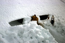
Part of Arthur Knight Slides
Colour photograph shows person excavating blocks of snow to build a snow cave
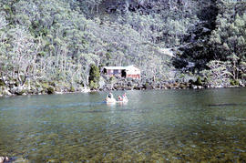
Moving firewood at Lake Dobson
Part of Arthur Knight Slides
Colour photographs shows three people in a small boat laden with firewood being moved from one side of Lake Dobson to another. Hut visible on shore and cleared path of zig-zag track up hill visible in background
Part of Arthur Knight Slides
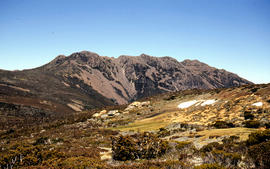
Colour photograph shows snow cover on Florentine Peak
Part of Arthur Knight Slides
Colour photograph shows ridge line of Florentine Peak, with small patches of snow in foreground
Part of Arthur Knight Slides
Colour photograph shows partial snow cover on Florentine Peak, looking west across mountains in distance
Part of Arthur Knight Slides
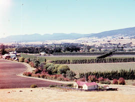
Colour photograph shows hop fields in at Glenora, 1959
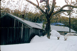
Part of Arthur Knight Slides
Colour photograph shows smoke curling out of the flue from a woodheater or fireplace of the Hobart Walking Club timber hut at Mount Field National Park, with snowdrifts banked halfway up the walls of the hut
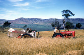
Farmer harvests grain at Glen Dhu
Part of Arthur Knight Slides
Colour photograph shows a farmer driving an International Harvester Farmall M tractor, with the Australian model name AM, pulling a trailed harvester in a paddock of rye at Glen Dhu, 1956. Placename distinct from other Glen Dhu, near Launceston.
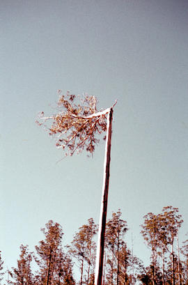
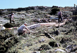
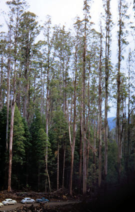
Heading a tree in the Florentine Valley
Part of Arthur Knight Slides
Colour portrait format photograph shows the head of a tall eucalypt tree falling when a timber worker chopped it down after scaling the three
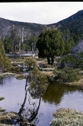
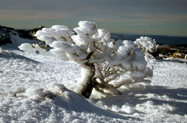
Shrub frozen at Mount Field West
Part of Arthur Knight Slides
Colour photograph shows ice formation on branches of shrub at Mount Field West, 1968
Part of Arthur Knight Slides
Colour photograph shows a person standing on ice at Lake Dobson, with ridge of snow above treeline
Part of Arthur Knight Slides
Colour photograph shows people assembling the roof frame of a Hobart Walking Club hut at K Col, later named the FA. Peterson Memorial Hut and officially opened in 1960 by New Zealand adventurer Sir Edmund Hilary
Part of Arthur Knight Slides
Colour photograph shows snow cover on K Col, 1963
Rusted locomotive in bush near Sharpes Siding
Part of Arthur Knight Slides
Colour photograph shows rusted locomotive with vertical boiler in bush near Sharpes Siding, a siding near Lake Tyenna Valley railway.
Part of Arthur Knight Slides
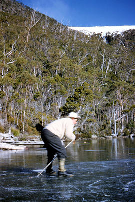
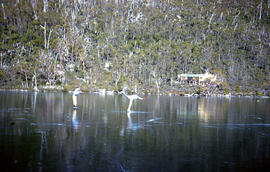
Colour photograph shows people ice skating on frozen surface of Lake Dobson
Oast houses and hop fields at Macquarie Plains
Part of Arthur Knight Slides
Colour photograph shows hop fields and kilns, or oast houses, at Macquarie Plains, with rail wagons and railway line in foreground
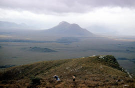
Mount Bowes from Sandfly Creek
Part of Arthur Knight Slides
Colour photograph shows Mount Bowes as viewed from Sandfly Creek
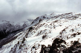
Mount Field West under snow as viewed from Rodway Range
Part of Arthur Knight Slides
Colour photograph from bank of River Derwent shows twisted railway track

Mount Field West from Rodway Range
Part of Arthur Knight Slides
Colour photograph shows Mount Field West from the Rodway Range
View of Mount Mawson from Florentine Peak saddle
Part of Arthur Knight Slides
Colour photograph shows Mount Mawson viewed from saddle of Florentine Peak, with partial snow cover
Mount Mueller from beyond Damper Inn hut
Part of Arthur Knight Slides
Colour photograph shows lightly timbered woodland near Mount Mueller
Part of Arthur Knight Slides
Colour photograph taken from elevated mountain ridge, shows valley floor looking west to Mount Solitary and original shoreline of Lake Pedder
Walkers on ridge overlooking Mount Solitary
Part of Arthur Knight Slides
Colour photograph shows some bushwalkers on a ridge overlooking the valley towards Mount Solitary
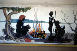
Mural in Hobart Walking Club hut
Part of Arthur Knight Slides
Colour photograph shows a mural in the Hobart Walking Club hut at Lake Dobson Source
Part of Arthur Knight Slides
Colour photograph shows snow skiers on Mount Mawson, one using a tow rope to climb uphill
Signs at entrance to Mount Field National Park
Part of Arthur Knight Slides
Colour photograph shows signs posted at entrance of Mount Field National Park, with distances and estimated travel times to Lake Dobson (9 1/4 miles), Lake Fenton (7 1/4 miles), Lady Barron Falls (1 1/2 mile), Camping Ground (250 yds), Rangers Cottage (150 Yds), Russell Falls 1/2 MILE 10 MIN, Lady Barron Falls Round Trip 3 1/2 MILES 1H 45 MIN
Part of Arthur Knight Slides
Colour photograph shows snow covering Tarn Shelf in Mount Field National Park
Marker on South Gordon walking track
Part of Arthur Knight Slides
Colour photograph shows unusual sign for South Gordon walking track turnoff, fashioned out of number plates, with three backpacks resting on ground nearby
Paddler in the Cruncher at Bradys Lake
Part of Arthur Knight Slides
Colour photograph shows a paddler of a kayak in the Cruncher a segment of water on the Bradys Lake whitewater course
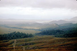
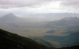
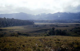
View of mountain ranges west of Mt. Lord
Part of Arthur Knight Slides
Colour photograph of mountain ranges west of Mt. Lord
Part of Arthur Knight Slides
Colour photograph shows rusted International Harvester locomotive on disused rails covered with bracken in a semi-cleared area of land
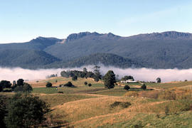
Fog in foothills of Ben Lomond
Part of Arthur Knight Slides
Colour photograph shows fog following the course of a creek in the foothills of Ben Lomond
Arthur Knight
Shoreline of Great Lake at Breona
Part of Arthur Knight Slides
Colour photograph depicts northern shoreline of Great Lake and settlement of Breona
Arthur Knight
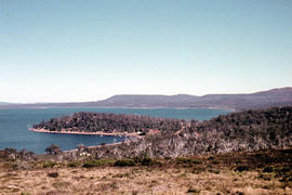
View of Lake St Clair from Mount Manfred
Part of Arthur Knight Slides
Colour photograph shows motor boat on Lake Trevallyn
Arthur Knight
Snow cover on Mount Olympus above Lake St Clair
Part of Arthur Knight Slides
Colour photograph shows snow above the treeline on Mount Olympus
Arthur Knight
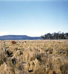
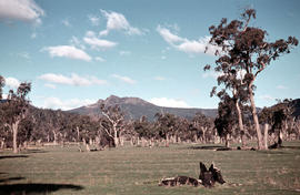
Table Mountain from Interlaken
Part of Arthur Knight Slides
Colour photograph shows cattle grazing in paddock near Interlaken, with flat-topped mountain in the distance
Arthur Knight
Waterfall on track to Meander Valley Falls
Part of Arthur Knight Slides
Colour photograph shows water spilling into a pool beside track to Meander Falls, with overhanging trees and vegetation surrounding stream
Arthur Knight
Treasurer's expenditure accounts
Analysis of expenditure for wages, provisions, clothing, fuel and light, stationery and printing, furniture and repairs, soap.
Girls Industrial School Hobart
Pictorial History of Sandy Bay Campus Buildings
The photographs show the University Campus at Sandy Bay during the construction of the buildings on the site.
University of Tasmania
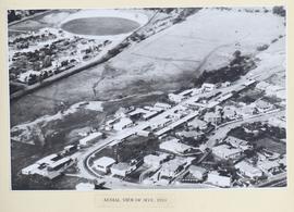
Photograph showing aerial view of the undeveloped site of the University Campus at Sandy Bay
University of Tasmania
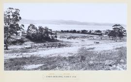
Photograph showing the initial stages of construction of the Union Building on the University Campus at Sandy Bay
University of Tasmania
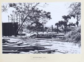
Photograph showing the early construction stage of Hytten Hall on the University Campus at Sandy Bay
University of Tasmania
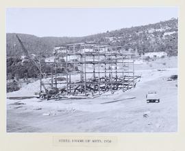
Photograph showing steel framework erected in the initial stages of the construction of the Arts Building on the University Campus at Sandy Bay
University of Tasmania
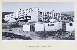
Arts, Education and Commerce Building
Photograph showing the Arts, Education and Commerce Building on the University Campus at Sandy Bay with the Morris Miller Library in the background.
University of Tasmania
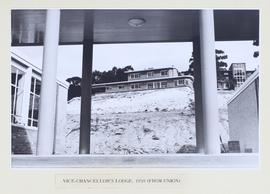
Photograph showing the Vice-Chancellor's Lodge on the University Campus at Sandy Bay taken from the Union Building
University of Tasmania
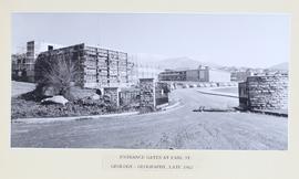
Photograph taken from the gates at Earle Street showing front view of the Geology-Geography Building under construction on the University Campus at Sandy Bay. Engineering Building in the background.
University of Tasmania
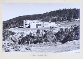
Photograph showing the Christ College building at the University Campus at Sandy Bay.
University of Tasmania
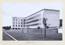
Photograph showing a front view of the completed Physics Building at the University Campus, Sandy Bay.
University of Tasmania
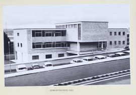
Photograph showing a front view of the completed Administration Building at the University Campus, Sandy Bay.
University of Tasmania