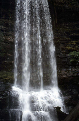
Side view of water flowing over Marriotts Falls
- AU TAS UTAS ITCCD 2017/2-174
- Pièce
Fait partie de Arthur Knight Slides
Colour portrait format photograph shows side view of the vertical drop of Marriotts Falls

Side view of water flowing over Marriotts Falls
Fait partie de Arthur Knight Slides
Colour portrait format photograph shows side view of the vertical drop of Marriotts Falls
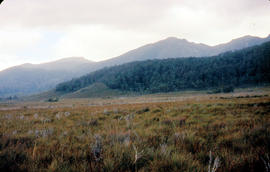
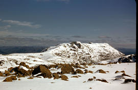
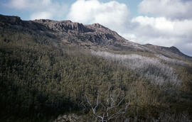
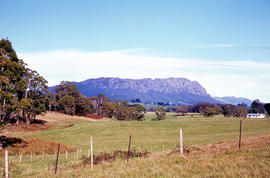
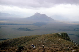
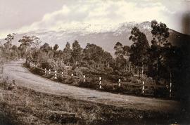
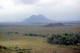
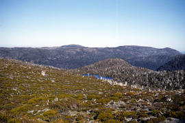
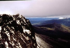
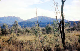
Mount Bowes from Sandfly Creek
Fait partie de Arthur Knight Slides
Colour photograph shows Mount Bowes as viewed from Sandfly Creek
Fait partie de Arthur Knight Slides
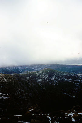
Colour portrait format photograph shows low cloud over Mount Bridges, with patches of snow on the ground
Mount Eliza covered in low cloud
Fait partie de Arthur Knight Slides
Colour photograph shows lightly timbered heath and woodland and Mount Eliza in the background covered in low cloud

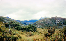
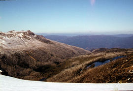
Mount Field West from Rodway Range
Fait partie de Arthur Knight Slides
Colour photograph shows Mount Field West from the Rodway Range
Mount Field West under snow as viewed from Rodway Range
Fait partie de Arthur Knight Slides
Colour photograph from bank of River Derwent shows twisted railway track
Fait partie de Photographs of Edward Verrell
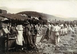
Black-and-white photograph shows men, women and children stripping hop cones into hessian-covered troughs, carrying baskets and sacks of harvested hops on the extensive hop grounds. The plant was cultivated widely at Glenorchy, Margate, Kingston and the Upper Derwent Valley area.
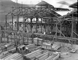
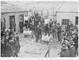
Looking north to cell room extension at E.Z. Co. Zinc Works
Fait partie de Photographs of E.Z. Co. Zinc Works at Risdon
Black-and-white photograph of construction of cell room extension at E.Z. Co. Zinc Works at Risdon. Large sign reading “SAFETY” is mounted at ground level.
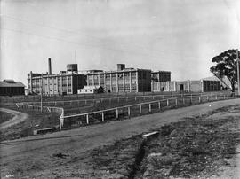
Three-storey buildings, Cadbury factory
Fait partie de Collection of Cadbury Claremont Images
Large three story complex forming part of the Cadbury factory.
Cadbury Fry Pascall Limited
Fait partie de Greg Dickens Photographic Collection
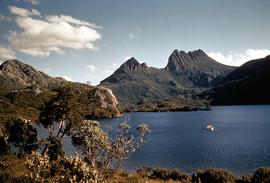
Colour photograph shows Cradle Mountain, with dinghy being rowed on Dove Lake in foreground
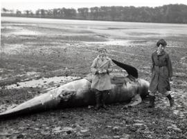
Children in overcoats stand next to dead whale
Fait partie de Graeme Raphael's collected photographs
Low tide, whale stranded ashore, possibly a long-finned pilot whale. Two children wearing overcoats inspecting the sea creature.
Graeme Raphael
Fait partie de Hal Wyatt Collection
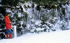
Colour photograph taken near the Springs of man dressed in red beside road to Mount Wellington, with icicles dangling from the vegetation after a snowstorm
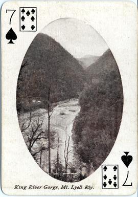
King River Gorge, Mt Lyell Railway
Fait partie de Images of West Coast Tasmania
The image appears on a printed playing card (7 of Spades) with legend in text at the bottom. The cards were part of a tourism promotion campaign by the Northern Tasmanian Tourist Association, printed and distributed just after the Great War (World War I).
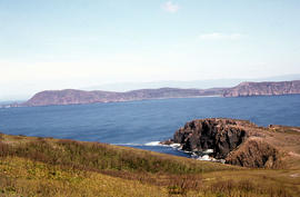
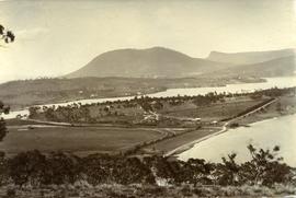
View of Cloudy Bay and West Cloudy Bay
Fait partie de Arthur Knight Slides
Colour photograph of Cloudy Bay and West Cloudy Bay, Bruny Island.
Fait partie de Arthur Knight Slides
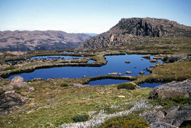
Colour photograph shows small tarns on alpine plateau at Mount Field West
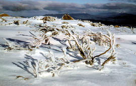
Ice-covered shrubs on Mount Mawson
Fait partie de Arthur Knight Slides
Colour photograph shows ice formation on branches of shrub at Mount Mawson
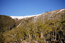
Trees on slope of Mount Mawson
Fait partie de Arthur Knight Slides
Colour photograph shows mature forest, amid some patches of dead tree cover, on steep slope at base of Mount Mawson
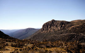
View of Mount Mawson from Florentine Peak saddle
Fait partie de Arthur Knight Slides
Colour photograph shows Mount Mawson viewed from saddle of Florentine Peak, with partial snow cover
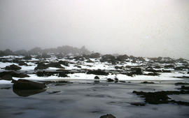
Low visibility on Mount Mawson plateau
Fait partie de Arthur Knight Slides
Colour photograph shows ice and snow amid rocky outcrops on Mount Mawson plateau
Ridgeline of Mount Mawson as viewed from Lake Dobson
Fait partie de Arthur Knight Slides
Colour photograph shows snow on the ridgeline of Mount Mawson as viewed from Lake Dobson
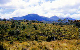
Mount Mueller from beyond Damper Inn hut
Fait partie de Arthur Knight Slides
Colour photograph shows lightly timbered woodland near Mount Mueller
Mount Roland as viewed from paddocks near Sheffield
Fait partie de Arthur Knight Slides
Colour photograph shows Mount Roland, south of Sheffield, with fenced pasture and bush
Fait partie de Arthur Knight Slides
Colour photograph taken from elevated mountain ridge, shows valley floor looking west to Mount Solitary and original shoreline of Lake Pedder
Walkers on ridge overlooking Mount Solitary
Fait partie de Arthur Knight Slides
Colour photograph shows some bushwalkers on a ridge overlooking the valley towards Mount Solitary
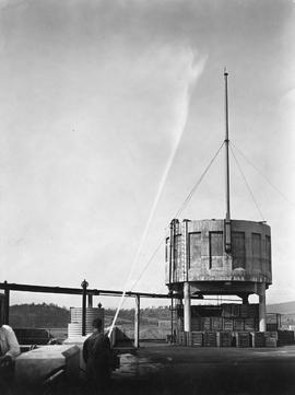
Fait partie de Collection of Cadbury Claremont Images
Large cement tank being sprayed with water by man holding high pressure fire hose.
View of snow on Mount Wellington from Huon Road
Fait partie de Photographs of Edward Verrell
Black-and-white photograph shows snow on Mount Wellington viewed from the verge of the Huon Road, South Hobart, with post-and-rail fence alongside roadway.
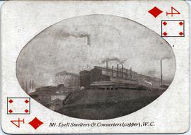
Mt Lyell Smelters & Converters (copper), WC
Fait partie de Images of West Coast Tasmania
The image appears on a printed playing card (4 of Diamonds) with legend in text at the bottom. Image shows significant industrial buildings in operation.
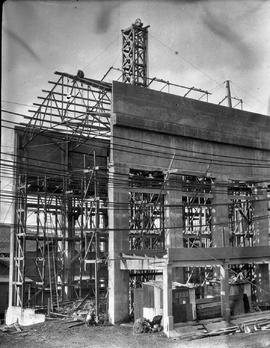
Concrete framework of new building at E.Z. Co. Zinc Works
Fait partie de Photographs of E.Z. Co. Zinc Works at Risdon
Black-and-white photograph depicts workman kneeling at base of partially constructed concrete-framed building and man straddling the roof beams on site of E.Z. Co. Zinc Works at Risdon
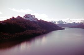
Fait partie de Hal Wyatt Collection
Colour photograph of snow-capped mountains beside Lake St Clair
View of Crater Lake, near Cradle Mountain
Fait partie de Greg Dickens Photographic Collection
Colour photograph shows Crater Lake, near Cradle Mountain
Decoration on Tasmanian Parliament House
Fait partie de Graeme Raphael's collected photographs
Parliament House Hobart. Flags being placed on front of building as decoration.
Graeme Raphael
View of Cloudy Bay from East Cloudy Head
Fait partie de Arthur Knight Slides
Colour photograph of Cloudy Bay from East Cloudy Head
Storm approaches Mount Solitary
Fait partie de Arthur Knight Slides
Colour photograph shows storm approaching Mount Solitary
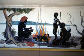
Mural in Hobart Walking Club hut
Fait partie de Arthur Knight Slides
Colour photograph shows a mural in the Hobart Walking Club hut at Lake Dobson Source
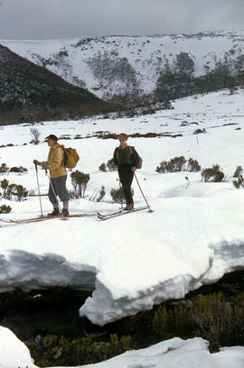
Fait partie de Arthur Knight Slides
Colour photograph shows two snow skiiers navigating patchy snow at National Park, a location in Mount Field National Park
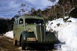
Vehicle on road at National Park
Fait partie de Arthur Knight Slides
Colour photograph shows two-tone green vehicle with driver's fingers visible on steering wheel, on the unsealed road at National Park, with snow covering the higher ground. Tasmanian number plate reads WLA 189 - 19 TAS 56.
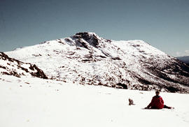
Walker sits on snow near Naturalist Peak
Fait partie de Arthur Knight Slides
Colour photograph shows person sitting on the snow near Naturalist Peak
Fait partie de Arthur Knight Slides
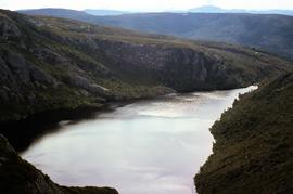
Colour photograph shows Lake Newdegate
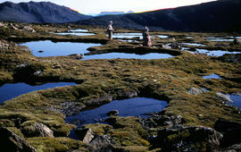
Fait partie de Arthur Knight Slides
Colour photograph shows three people resting at Newdegate Pass in Mount Field National Park
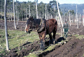
Man and horse ploughing at Westerway
Fait partie de Arthur Knight Slides
Colour photograph shows a farmer ploughing a paddock at Westerway in a field strung with trellis frames for hop cultivation with a draught horse and plough
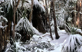
Fait partie de Arthur Knight Slides
Colour photograph shows leaves of Pandani covered by snowfall
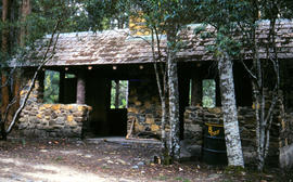
Picnic hut near National Park entrance
Fait partie de Arthur Knight Slides
Colour photograph shows picnic hut near road entrance of Mount Field National Park
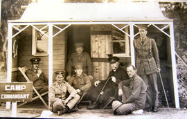
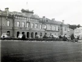
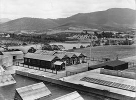
Men on verandah of Camp Commandant Cottage
Fait partie de Collection of Cadbury Claremont Images
Black and white photograph of Camp Commandant's hut with men in uniform seated outside, part of the Claremont military camp.
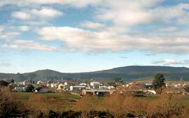
View of Bothwell in winter, 1981
Fait partie de Greg Dickens Photographic Collection
Colour landscape photograph showing township of Bothwell, looking east across the willows on the banks of the River Clyde, taken in winter 1981.
Fait partie de Hal Wyatt Collection
Colour photograph shows patchy snow covering Barn Bluff and Cradle Mountain, photograph taken 1970.
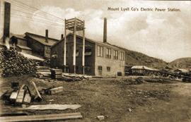
View of Mount Lyell Co's Electric Power Station, Queenstown Tasmania
Fait partie de Images of West Coast Tasmania
Image is slightly out of focus and contains text identifying the subject. Possibly originally a post card.
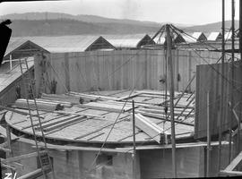
Detail Camp under construction
Fait partie de Collection of Cadbury Claremont Images
A collection of buildings identified as Detail Camp, part of the Claremont military camp.
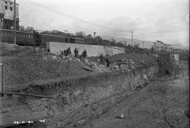
Excavation and construction below railway line at Risdon
Fait partie de Photographs of E.Z. Co. Zinc Works at Risdon
Black-and-white photograph shows excavation and construction of retaining walls at E.Z. Co. Zinc Works at Risdon below the level of the railway line
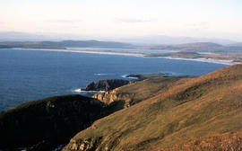
Adventure Bay near Cape Queen Elizabeth
Fait partie de Arthur Knight Slides
View from headland of Adventure Bay near Cape Queen Elizabeth on Bruny Island.
Arthur Knight
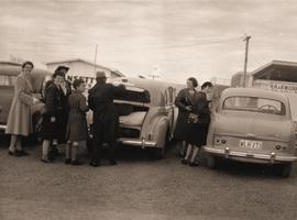
People at Hobart airport car park
Fait partie de Graeme Raphael's collected photographs
Photograph shows two groups of people in an airport car park, including three children wearing school uniform. An Ansett Airways logo visible on building.
Graeme Raphael
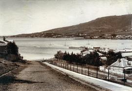
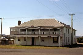
View from Bath Street, Battery Point
Fait partie de Photographs of Edward Verrell
Black-and-white photograph of Bath Street, Battery Point, looking across Derwent River to Sandy Bay and St Helena Point.
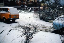
Fait partie de Hal Wyatt Collection
Colour photograph of snow at Malunna Road, Lindisfarne, 1986
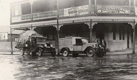
View of motor vehicles outside the Queenstown Hotel, Queenstown, Tasmania
Fait partie de Images of West Coast Tasmania
Image centres on the two motor vehicles and adjacent figures, showing the ground and part of the first storey of the Queenstown Hotel. Affixed to first-storey railing is a large banner promoting Newtown v Queenstown football match on Saturday August 6th.

Former Crown Inn, reopened as The Crown Lodge at Bothwell
Fait partie de Greg Dickens Photographic Collection
Colour photograph shows Ford XF Falcon motor vehicle parked out front of the Crown Lodge, 15 Alexander Street Bothwell, with sandwich board and hand painted “Now Open” sign
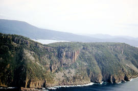
Aerial view of Fluted Cape, South Bruny Island
Fait partie de Arthur Knight Slides
Colour aerial photograph of Fluted Cape, South Bruny Island, 1956
Construction of pure solution tank at E.Z. Co. Zinc Works
Fait partie de Photographs of E.Z. Co. Zinc Works at Risdon
Black-and-white photograph shows construction of No. 6 pure solution tank in the cell division at E.Z. Co. Zinc Works at Risdon, January 1930
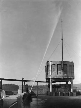
Fait partie de Collection of Cadbury Claremont Images
Large cement tank being sprayed with water by man holding high pressure fire hose.
Fait partie de Photographs of Edward Verrell
Black-and-white photograph shows dwellings, fences and farmland at Lindisfarne Bay, looking across Derwent River to Hobart
Fait partie de Graeme Raphael's collected photographs
Bridge crossing Dee river, winding road and hills evident.
Graeme Raphael
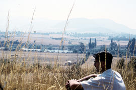
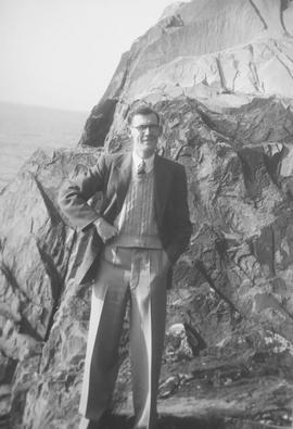
Man sitting in long grass at Plenty
Fait partie de Arthur Knight Slides
Colour photograph shows many with dark hair and spectacles sitting on the edge of cleared farmland at Plenty beside river
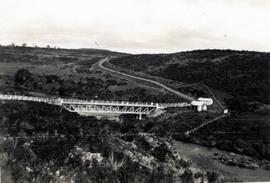
Timber bridge across Plenty River
Fait partie de Arthur Knight Slides
Colour photograph shows the timber frame of the bridge across the Plenty River
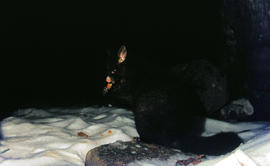
Fait partie de Arthur Knight Slides
Colour photograph shows a possum eating something in the snow at Lake Dobson 1968
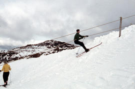
Fait partie de Arthur Knight Slides
Colour photograph shows snow skiers on Mount Mawson, one using a tow rope to climb uphill
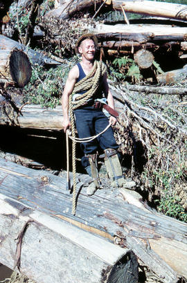
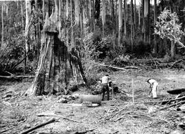
Rigger in the Florentine Valley
Fait partie de Arthur Knight Slides
Colour photograph shows timber worker wearing hard hat, chaps and holding ropes and an axe, standing on fallen logs in the Florentine Valley
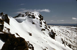
Fait partie de Arthur Knight Slides
Colour photograph shows snow cover on the Rodway Range
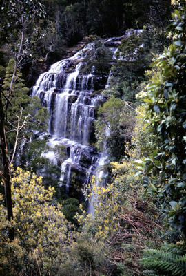
Fait partie de Arthur Knight Slides
Colour photograph shows Russell Falls as viewed from elevated vantage point in rainforest
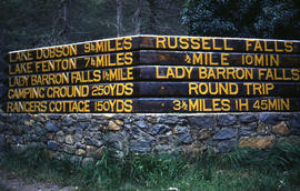
Signs at entrance to Mount Field National Park
Fait partie de Arthur Knight Slides
Colour photograph shows signs posted at entrance of Mount Field National Park, with distances and estimated travel times to Lake Dobson (9 1/4 miles), Lake Fenton (7 1/4 miles), Lady Barron Falls (1 1/2 mile), Camping Ground (250 yds), Rangers Cottage (150 Yds), Russell Falls 1/2 MILE 10 MIN, Lady Barron Falls Round Trip 3 1/2 MILES 1H 45 MIN
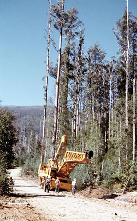
Four men standing around Skagit loader
Fait partie de Arthur Knight Slides
Colour photograph shows timber workers in hard hats standing around an unladen Skagit loader with an operator visible in the cabin, on a dirt track in the bush
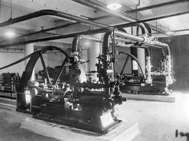
Fait partie de Collection of Cadbury Claremont Images
Piston engines.
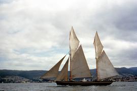
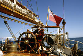
Fait partie de Hal Wyatt Collection
Colour photograph of SV May Queen, sailing on Derwent River in trading vessel race in 1954
Gap between two Friars, off Bruny Island, 1962
Fait partie de Arthur Knight Slides
Colour photograph taken at sea level of the gap between vertical cliffs of two islands in the Friars island group, off the southern coast of Bruny Island
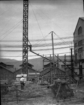
Concrete pouring tower hoisted at E.Z. Co. Zinc Works
Fait partie de Photographs of E.Z. Co. Zinc Works at Risdon
Black-and-white photograph shows concrete pouring tower, held in position with stays during expansion of power house at E.Z. Co. Zinc Works at Risdon
Fait partie de Greg Dickens Photographic Collection
Colour photograph shows former Crown Inn at 15 Alexander Street, Bothwell, with distinctive colour crown insignia above first-storey veranda and coloured light globes mounted along balcony
Black and white photograph of big tree stump
Fait partie de Graeme Raphael's collected photographs
Two men putting in posts to erect fencing in bush clearing. Big tree stump nearby. Posts, roll of wire fencing on ground.
Graeme Raphael
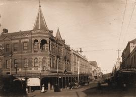
Miller’s Corner at Liverpool and Murray streets, Hobart
Fait partie de Photographs of Edward Verrell
Black-and-white photograph depicts Miller’s Corner on the intersection of Liverpool Street and Murray streets, Hobart, looking towards waterfront down Murray Street. A.P. Miller, dispensing chemist, died 1904
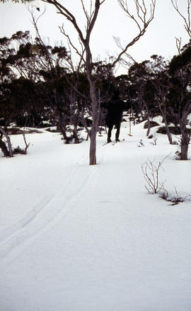
Snow skier plays trick on camera
Fait partie de Arthur Knight Slides
Colour photograph shows the tracks of a snow skier, dressed in dark clothing, going around both sides of a tree on a snow-covered, lightly wooded hill
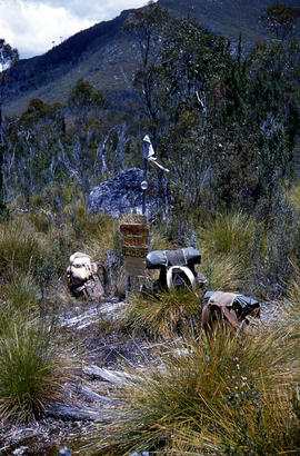
Marker on South Gordon walking track
Fait partie de Arthur Knight Slides
Colour photograph shows unusual sign for South Gordon walking track turnoff, fashioned out of number plates, with three backpacks resting on ground nearby
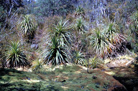
Fait partie de Arthur Knight Slides
Colour photograph shows mossy ground surrounding a group of pandani plants
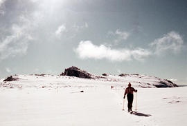
Man skiing downhill on Mount Field West
Fait partie de Arthur Knight Slides
Colour photograph shows man skiing downhill at Mount Field West, with two other figures behind him near the summit of mountain
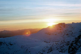
Fait partie de Arthur Knight Slides
Colour photograph shows setting sun from the summit of Mount Field West
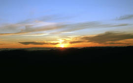
View of sunset from Rodway Range
Fait partie de Arthur Knight Slides
Colour photograph shows sunset as viewed from Rodway Range
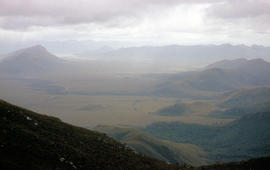
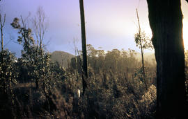
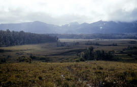
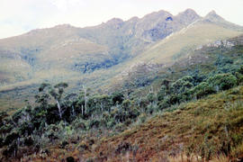
View of heathland near Mount Bowes
Fait partie de Arthur Knight Slides
Colour photograph shows heathland looking southwest from near Mount Bowes
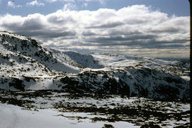
Fait partie de Arthur Knight Slides
Colour photograph shows snow covering Tarn Shelf in Mount Field National Park
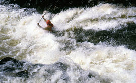
Paddler in the Cruncher at Bradys Lake
Fait partie de Arthur Knight Slides
Colour photograph shows a paddler of a kayak in the Cruncher a segment of water on the Bradys Lake whitewater course
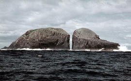
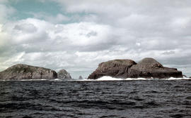
The Druids as viewed from Woody Island
Fait partie de Arthur Knight Slides
Colour photograph shows The Druids as viewed from Woody Island
View of the Friars, off South Bruny Island
Fait partie de Arthur Knight Slides
Colour photograph of Friars island group
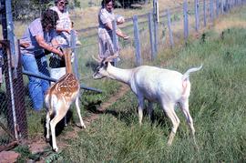
Deer being fed at Thorpe Farm, Bothwell
Fait partie de Greg Dickens Photographic Collection
Colour photograph shows deer being offered food by visitors to Bothwell
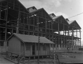
Corrugated iron shed dwarfed by larger building under construction at E.Z. Co. Zinc Works at Risdon
Fait partie de Photographs of E.Z. Co. Zinc Works at Risdon
Black-and-white photograph shows small corrugated iron cottage or shed on a hillside below larger, open-fronted building under construction at E.Z. Co. Zinc Works at Risdon
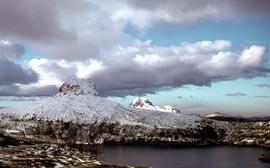
Aerial view of Mount Field West and Mount Mueller
Fait partie de Hal Wyatt Collection
Colour aerial photograph of Mount Field West and Mount Mueller 1970
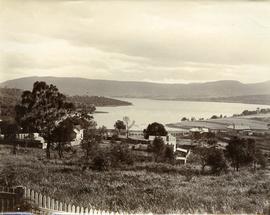
View from Queens Domain looking north to Cornelian Bay and New Town Bay
Fait partie de Photographs of Edward Verrell
Black-and-white photograph taken from elevated point on Queen’s Domain, looking north up Derwent River towards Cornelian Bay and New Town Bay; Risdon Park Racecourse (1880s-1926) at New Town in foreground, early burial plots in headland of Cornelian Bay Cemetery at right of picture.
View of woodchoppers Burge and Garcie preparing for competition, Queenstown Tasmania
Fait partie de Images of West Coast Tasmania
Image likely taken from a newspaper and has a partial printed legend at the bottom: 6 T. Garcie, of Strahan (left) v W . Burge, of Crotty (right). Won by Burge.
Wooden Buildings, Cadbury Factory
Fait partie de Collection of Cadbury Claremont Images
Interlinking wooden buildings on Cadbury site, with Derwent River in background.
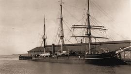
Sailing ship Discovery docked in Hobart
Fait partie de Graeme Raphael's collected photographs
Discovery, a three-masted wooden ship docked at wharf in Hobart
Graeme Raphael
The Druids near Huon River crossing
Fait partie de Arthur Knight Slides
Colour photograph shows The Druids from near the Huon River crossing
Fait partie de Arthur Knight Slides
Colour photograph shows The Watcher
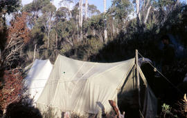
Tents pitched at Mount Bowes campsite
Fait partie de Arthur Knight Slides
Colour photograph shows two canvas tents pitched in hilly scrubland at Mount Bowes
Fait partie de Arthur Knight Slides
Colour photograph shows bushwalker with backpack in heath and woodland walking towards the Gordon River
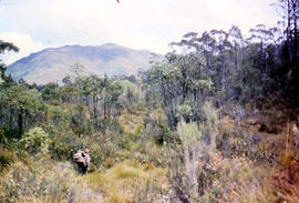
Bushwalking near Sandfly Creek
Fait partie de Arthur Knight Slides
Colour photograph shows two bushwalkers with backpacks near a track to Sandfly Creek