- AU TAS UTAS ITCCD 2017/18-0421
- Pièce
- 1950's
Fait partie de Collection of Cadbury Claremont Images
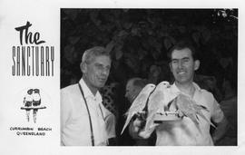
Postcard from The Sanctuary Currumbin Beach, Queensland. Two men pictured, one holding bird feeder dish with parrots sitting around rim of dish eating.
Fait partie de Collection of Cadbury Claremont Images
Postcard from The Sanctuary Currumbin Beach, Queensland. Two men pictured, one holding bird feeder dish with parrots sitting around rim of dish eating.
Fait partie de Collection of Cadbury Claremont Images
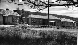
Houses under construction, possibly on the Cadbury Estate.
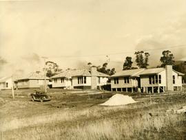
Several houses under construction
Fait partie de Collection of Cadbury Claremont Images
Several houses under construction, possibly on the Cadbury Estate.
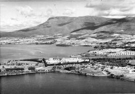
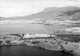
Derwent River and Cadbury Factory
Fait partie de Collection of Cadbury Claremont Images
Derwent River, Cadbury Factory and surrounding suburb of Berriedale. Mount Wellington and foothills in background.
Derwent River and Cadbury Factory
Fait partie de Collection of Cadbury Claremont Images
Derwent River, Cadbury Factory and surrounding suburb of Berriedale. Mount Wellington and foothills in background.
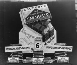
Cadbury Caramello Chocolate Display
Fait partie de Collection of Cadbury Claremont Images
Display of Cadbury Caramello chocolate blocks showing a price reduction to sixpence.
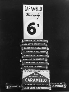
Cadbury Caramello Chocolate Display
Fait partie de Collection of Cadbury Claremont Images
Display of Cadbury Caramello chocolate blocks showing a price reduction to sixpence.
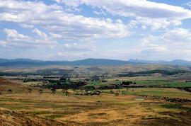
Fait partie de Greg Dickens Photographic Collection
Colour landscape photograph of property Cawood, Ouse,
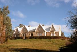
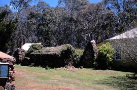
Clifton Priory atop Barrack Hill, Bothwell
Fait partie de Greg Dickens Photographic Collection
Colour photograph of Clifton Priory, Bothwell. National heritage register citation is as follows: “Two storey stone Tudor Gothic house built in 1847-8 by Rev. Robert Wilson from public subscription. Wilson caused a scandal when he ran into financial difficulties and sold it owing a considerable sum. The house is magnificently sited on Barrack Hill from where it enjoys fine views of Bothwell, the Clyde River and surrounding countryside.”
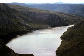
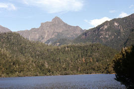
View of Crater Lake, near Cradle Mountain
Fait partie de Greg Dickens Photographic Collection
Colour photograph shows Crater Lake, near Cradle Mountain
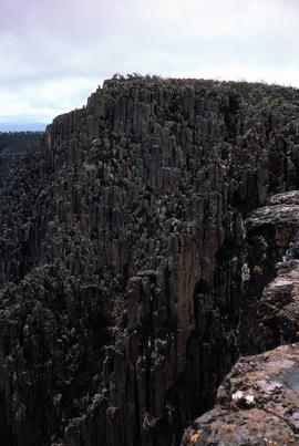
Fait partie de Greg Dickens Photographic Collection
Colour photograph shows view from Devils Gullet Lookout
Fait partie de Greg Dickens Photographic Collection
Colour photograph taken in winter showing side view of St James Chapel at Montacute, with the Hallett family serving as caretakers, since 1897
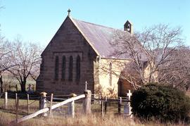
View of church yard surrounding St James chapel at Montacute
Fait partie de Greg Dickens Photographic Collection
Colour photograph taken in winter, shows burial ground and churchyard surrounding St James Chapel at Montacute, under the care of the Hallett Family, since 1897
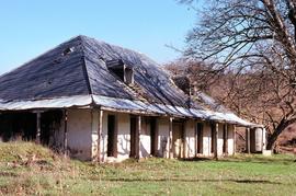
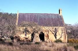
Abandoned slate-roofed homestead at Montacute
Fait partie de Greg Dickens Photographic Collection
Colour photograph of slate-roofed dwelling with dormer windows and veranda on the property at Montacute, Hollow Tree
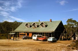
Fait partie de Greg Dickens Photographic Collection
Colour photograph of Pencil Pine Lodge near Cradle Mountain, with cars parked outside accommodation block near Golden Fleece petrol bowser
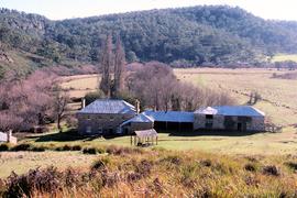
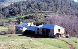
View of Sherwood, homestead in Clyde River Valley
Fait partie de Greg Dickens Photographic Collection
Colour photograph of sandstone homestead, Sherwood, with nearby outbuildings, willows lining the banks of nearby Clyde River at Hollow Tree
Fait partie de Greg Dickens Photographic Collection
Colour photograph of sandstone homestead, Sherwood, with farm outbuildings and Clyde River Valley
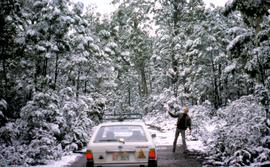
Fait partie de Greg Dickens Photographic Collection
Colour photograph shows man standing beside Subaru station wagon on road through snow-covered forest near Tarraleah
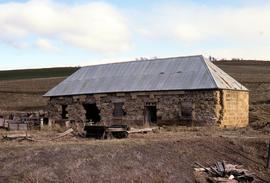
Stable ruins at Langloh Colliery
Fait partie de Greg Dickens Photographic Collection
Colour photograph of abandoned Langloh coalmine and colliery near Hamilton
Fait partie de Greg Dickens Photographic Collection
Colour photograph of exterior of the Steppes homestead, on the Lake Highway
Headrace at Tarraleah Power Station
Fait partie de Greg Dickens Photographic Collection
Colour photograph looking downhill to Tarraleah Power Station
Fait partie de Greg Dickens Photographic Collection
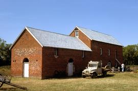
Colour photograph shows Toyota Landcruiser parked outside Thorpe Water Mill at Bothwell
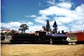
Children playing on black steam locomotive
Fait partie de Graeme Raphael's collected photographs
Black steam locomotive uncoupled from carriages, with several children climbing and playing on engine.
Graeme Raphael
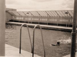
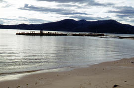
Swimming pool at Wrest Point Casino
Fait partie de Graeme Raphael's collected photographs
Outdoor swimming pool with wall of glass providing windbreak.
Graeme Raphael
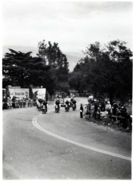
Escort for car near the Domain
Fait partie de Graeme Raphael's collected photographs
Group of motor bikes escorting car up slope. Crowds lining either side of road.
Graeme Raphael
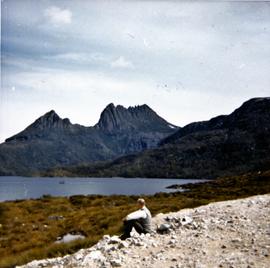
Man sitting on gravel near Cradle Mountain
Fait partie de Graeme Raphael's collected photographs
Colour photograph of Cradle Mountain with man seated on rocks in foreground. Dove Lake.
Graeme Raphael
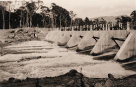
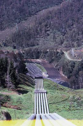
Water flows through dam spillway
Fait partie de Graeme Raphael's collected photographs
Black and white photograph of water flowing through spill way on dam, with snow capped mountain in distance.
Graeme Raphael
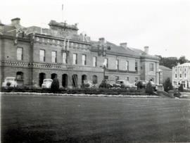
Decoration on Tasmanian Parliament House
Fait partie de Graeme Raphael's collected photographs
Parliament House Hobart. Flags being placed on front of building as decoration.
Graeme Raphael
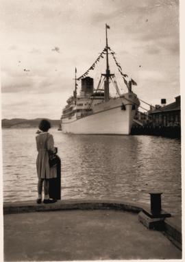
Fait partie de Graeme Raphael's collected photographs
Passenger liner Gothic at Princess Wharf, Hobart
Graeme Raphael
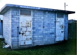
Fait partie de Graeme Raphael's collected photographs
Small cement block building with two padlocked doors with grilles above.
Graeme Raphael
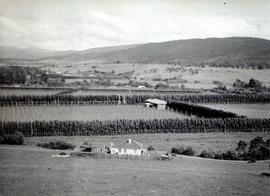
Fait partie de Graeme Raphael's collected photographs
Photograph of several hop fields bordered by windbreak trees, possibly poplars
Graeme Raphael
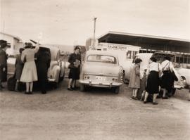
Loading luggage at Hobart Aerodrome
Fait partie de Graeme Raphael's collected photographs
Group of people loading or unloading luggage from the rear boot of vehicles parked in the car park at Hobart Aerodrome. Building site and an aircraft parked on tarmac visible in background.
Graeme Raphael
Decorative seat at Royal Botanical Gardens
Fait partie de Photographs of Edward Verrell
Black-and-white photograph of Royal Botanical Gardens, showing a decorative undercover seat constructed around the stump and butt of a tree. Government House visible in background
View of Dunkleys Point at Sandy Bay
Fait partie de Photographs of Edward Verrell
Black-and-white photograph shows Sandy Bay Road in foreground, the grand home St Helena on what is known as Dunkleys Point, and Battery Point on the opposite shore of the bay
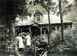
Visitors at Falls Hut, Mount Wellington
Fait partie de Photographs of Edward Verrell
Black-and-white photograph shows visitors standing on front steps and veranda at Falls Hut, built 1897, at the Cascades, on road to Mount Wellington
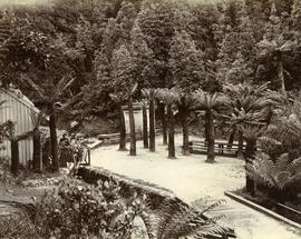
Fait partie de Photographs of Edward Verrell
Black-and-white photograph shows walking path at Fern Tree Bower, Mount Wellington
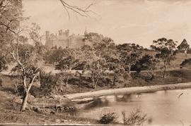
Government House in Hobart, viewed from the river, across Rose Bay
Fait partie de Photographs of Edward Verrell
Black-and-white photograph shows waves lapping shoreline of Derwent River in foreground, with Government House on the hill, surrounded by mature trees, tall picket fence runs parallel with river, two wires strung between poles, visible through trees
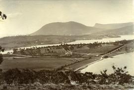
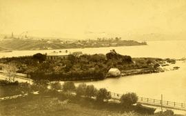
View from Queens Domain looking north to Cornelian Bay and New Town Bay
Fait partie de Photographs of Edward Verrell
Black-and-white photograph taken from elevated point on Queen’s Domain, looking north up Derwent River towards Cornelian Bay and New Town Bay; Risdon Park Racecourse (1880s-1926) at New Town in foreground, early burial plots in headland of Cornelian Bay Cemetery at right of picture.
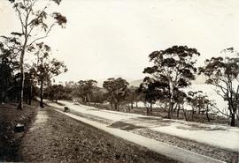
Road to Government House, on Gun Carriage Drive
Fait partie de Photographs of Edward Verrell
Black-and-white photograph taken looking north along Gun Carriage Drive towards Government House, Hobart, with post-and-rail fences on Derwent River side; a horse harnessed to a four-wheel carriage, is on the left of the road; a small jetty extends from the shoreline and a boat is visible through the trees, anchored just off shore.
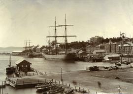
Ships docked at New Wharf, Hobart
Fait partie de Photographs of Edward Verrell
Black-and-white photograph shows sailing ships moored at New Wharf, Hobart, in front of Salamanca Place, with milled timber stacked on edge of wharf
Fait partie de Arthur Knight Slides
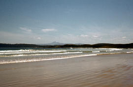
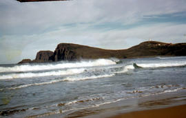
Colour photograph taken from beach at Cloudy Bay on Bruny Island, looking west to Adamsons Peak on Tasmanian mainland
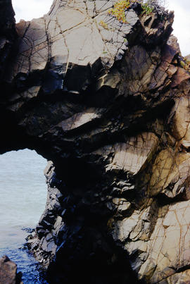
Cape Elizabeth arch on North Bruny Island
Fait partie de Arthur Knight Slides
Colour photograph of archway at Cape Elizabeth on shoreline at North Bruny Island
Arthur Knight
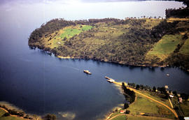
Aerial picture of boat in Barnes Bay
Fait partie de Arthur Knight Slides
Colour photograph from the air showing a boat in Barnes Bay approaching or leaving jetty.
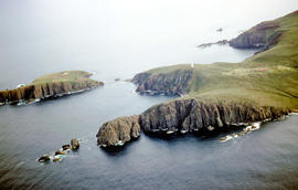
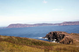
Aerial view of Cape Bruny from south-east
Fait partie de Arthur Knight Slides
Colour photograph of Cape Bruny taken from the air. Photograph depicts coastline of South Bruny Island including lighthouse, Courts Island, Lighthouse Bay
View of Cape Bruny and lighthouse from Lighthouse Bay
Fait partie de Arthur Knight Slides
Colour photograph of waves breaking in Lighthouse Bay, with cliffs and headland of Cape Bruny and Bruny Island Lighthouse in background. Discolouration in scanned image from original slide.
View of Cape Bruny and lighthouse from Lighthouse Bay
Fait partie de Arthur Knight Slides
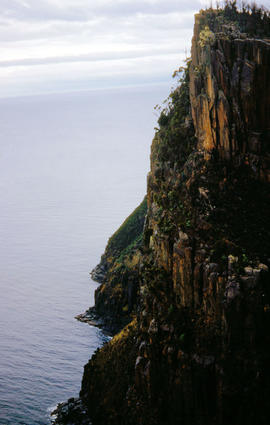
Colour photograph of cliffs of Cape Connella, South Bruny Island
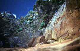
View of shoreline at base of Cape Connella, looking down cliff face
Fait partie de Arthur Knight Slides
Colour photograph of shoreline at base of Cape Connella, South Bruny Island, looking down the cliff face.
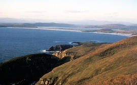
View of Cloudy Bay and West Cloudy Bay
Fait partie de Arthur Knight Slides
Colour photograph of Cloudy Bay and West Cloudy Bay, Bruny Island.
View of Cloudy Bay from East Cloudy Head
Fait partie de Arthur Knight Slides
Colour photograph of Cloudy Bay from East Cloudy Head
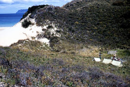
View of Bruny Island campsite of Hobart Walking Club 1955
Fait partie de Arthur Knight Slides
Colour photograph of heath and sand dunes, site of Hobart Walking Club campsite near Cape Queen Elizabeth on Bruny Island,1955
Section of old bridge at Alonnah
Fait partie de Arthur Knight Slides
Colour photograph of old Hobart Bridge section tethered offshore at Alonnah

Staircase in Bruny Island Lighthouse
Fait partie de Arthur Knight Slides
Colour photograph taken inside Bruny Island Lighthouse showing metal staircase
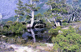
Trees reflected in Artists Pool
Fait partie de Arthur Knight Slides
Colour photograph of Artists Pool, a waterhole near Cradle Mountain, with reflections of alpine plants on the water's surface

Fait partie de Arthur Knight Slides
Colour photograph shows a person pointing at a dead bird on the ground near Bare Mountain, with new undergrowth shooting after a recent bushfire and several bushwalkers visible in the distance

Fait partie de Arthur Knight Slides
Colour photograph of two walkers trying to avoid slippery pathway with flecks of snow on ground and Barn Bluff in background

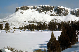
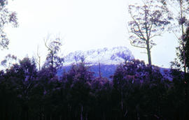
Barn Bluff as viewed from Cradle Mountain
Fait partie de Arthur Knight Slides
Colour photograph of Barn Bluff as viewed form Cradle Mountain with some snow remaining on the ridgelines of the cirque

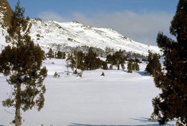
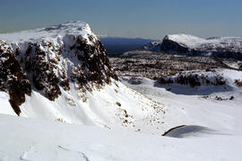
Central Highlands from Cradle Mountain
Fait partie de Arthur Knight Slides
Colour photograph shows mountains of Central Highlands as viewed from Cradle Mountain

Misty morning at Cloister Lagoon
Fait partie de Arthur Knight Slides
Colour photograph shows mist above the surface of Cloister Lagoon just before daybreak

Cradle Mountain from Dove Lake
Fait partie de Arthur Knight Slides
Colour photograph shows light dusting of snow on Cradle Mountain from Dove Lake

Fait partie de Arthur Knight Slides
Colour photograph shows ridge of rock from Dove Lake

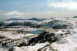
Pencil Pines on shore of Crater Lake
Fait partie de Arthur Knight Slides
Colour photograph shows Crater Lake, with remnants of snow on rock ledge

Fait partie de Arthur Knight Slides
Colour photograph shows Crater Lake

Fait partie de Arthur Knight Slides
Colour photograph shows bed of green cushion plants

Wildflowers on Cathedral Mountain
Fait partie de Arthur Knight Slides
Colour photograph of wildflower in alpine environment

Snowfall at Jaffa Vale and Mount Olympus
Fait partie de Arthur Knight Slides
Colour photograph shows tracks of snow skiers at Jaffa Vale and Mount Olympus

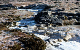
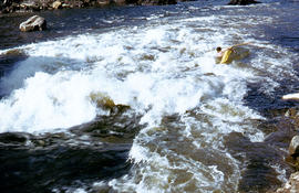
Fait partie de Arthur Knight Slides
Colour photograph of limited water flow across Knyvet Falls 1984 GIS: Latitude -4159 Longitude 14593 Gazetteer Australia Record_ID TAS06008

Shoreline of Lake Chalice 1979
Fait partie de Arthur Knight Slides
Colour photograph shows the rocky shoreline of Chalice Lake GIS: Latitude -4188 Longitude 14615 Gazetteer Australia Record_ID TAS02044
Cliffs of Mount Anne above Lake Timk
Fait partie de Arthur Knight Slides
Colour photograph shows the cliffs of Mount Anne above Lake Timk

Fait partie de Arthur Knight Slides
Colour photograph shows Lake Timk and Mount Anne in distance GIS: Latitude -4293 Longitude 14646 Gazetteer Australia Record_ID TAS16882

Reflection of Mount Anne on surface of Lake Timk
Fait partie de Arthur Knight Slides
Colour portrait format photograph shows reflection of Mount Anne on the surface of Lake Timk

Mount Ossa and Cathedral Mountain
Fait partie de Arthur Knight Slides
Colour photograph shows rocky peak of Mount Rogoona, with alpine plain in foreground

Fait partie de Arthur Knight Slides
Colour photograph shows Mount Rogoona with Lake Myrtle obscured by light alpine forest vegetation on ridge

Panoramic view of Mount Rogoona
Fait partie de Arthur Knight Slides
Colour photograph shows farmland in the Kentish area with Mount Roland in background

View across Cradle Mountain ridges to the north
Fait partie de Arthur Knight Slides
Colour photograph shows people standing outside Northern Tasmanian Alpine Club hut at Ben Lomond, one holding snow skis and poles
Creek on plateau above Cradle Mountain
Fait partie de Arthur Knight Slides
Colour photograph shows plateau near summit of Ben Lomond
Pool of Siloam & The Temple 1978
Fait partie de Arthur Knight Slides
Colour photograph shows snow covering Pool of Siloam near the West Wall of Mount Jerusalem
Pool of Siloam and the West Wall of Mount Jerusalem
Fait partie de Arthur Knight Slides
Colour photograph shows dolerite peak of Ragged Jack, near Ben Lomond, viewed across from lightly timbered farmland
Fait partie de Arthur Knight Slides
Colour photograph of Strickland Valley near Ben Lomond, with partial snow cover, 1960
Fait partie de Arthur Knight Slides
Colour photograph shows heavy snow cover on forest at West Wall near Mount Jerusalem
Western Bluff & Lake Thor 1978
Fait partie de Arthur Knight Slides
Colour photograph shows view west from Back Mountain 1983
Fait partie de Arthur Knight Slides
Colour photograph shows a kayaker falling into the Derwent River, below the site of the Repulse Dam, in 1964
Fait partie de Arthur Knight Slides
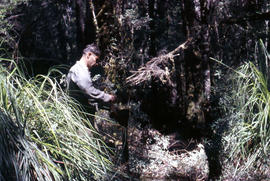
Colour photograph shows man repairing boots in shade of forest
Fait partie de Arthur Knight Slides
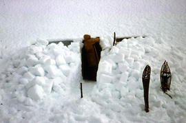
Colour photograph shows a snow cave excavation
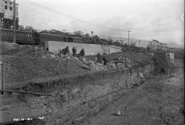
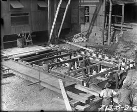
Excavation and construction below railway line at Risdon
Fait partie de Photographs of E.Z. Co. Zinc Works at Risdon
Black-and-white photograph shows excavation and construction of retaining walls at E.Z. Co. Zinc Works at Risdon below the level of the railway line
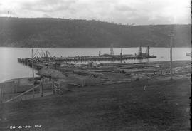
Construction of new Risdon wharf
Fait partie de Photographs of E.Z. Co. Zinc Works at Risdon
Black-and-white photograph shows construction of wharf at E.Z. Co. Zinc Works at Risdon
Cladding a building at E.Z. zinc works
Fait partie de Photographs of E.Z. Co. Zinc Works at Risdon
Black-and-white photograph depicts workers fixing corrugated iron sheets to exterior wall of a new building at E.Z. Co. Zinc Works at Risdon
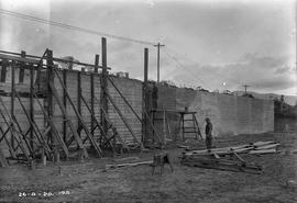
Construction of retaining wall at E.Z. Co Zinc Works
Fait partie de Photographs of E.Z. Co. Zinc Works at Risdon
Black-and-white photograph depicts workers building a retaining wall at E.Z. Co. Zinc Works at Risdon
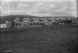
Exterior view of cell room at E.Z. Co. Zinc Works 100-ton plant
Fait partie de Photographs of E.Z. Co. Zinc Works at Risdon
Black-and-white photograph shows exterior of newly constructed cell room at E.Z. Co. Zinc Works at Risdon viewed from the south, looking downhill to the Derwent River.
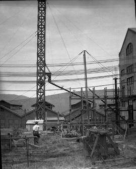
Concrete pouring tower hoisted at E.Z. Co. Zinc Works
Fait partie de Photographs of E.Z. Co. Zinc Works at Risdon
Black-and-white photograph shows concrete pouring tower, held in position with stays during expansion of power house at E.Z. Co. Zinc Works at Risdon

Workers assembling jacket of Derwent Prime furnace at E.Z. Co. Zinc Works
Fait partie de Photographs of E.Z. Co. Zinc Works at Risdon
Black-and-white photograph shows men assembling sides and ends of jacket of Derwent Prime furnace at E.Z. Co. Zinc Works at Risdon
Staging for Derwent Prime furnace jacket at E.Z. Co. Zinc Works
Fait partie de Photographs of E.Z. Co. Zinc Works at Risdon
Black-and-white photograph shows men building staging for Derwent Prime furnace at E.Z. Co. Zinc Works at Risdon
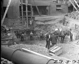
Excavation for Derwent Prime furnace at E.Z. Co. Zinc Works
Fait partie de Photographs of E.Z. Co. Zinc Works at Risdon
Black-and-white photograph shows workmen digging earth and rubble to be loaded into a horse-drawn cart at excavation site for new Derwent Prime furnace being built at E.Z Co. Zinc Works 1930
Framework for pouring concrete in the power station building at E.Z. Co. Zinc Works
Fait partie de Photographs of E.Z. Co. Zinc Works at Risdon
Black-and-white photograph shows workmen sitting down and horse eating from nosebag in front of timber framework for concrete pour for construction of power station building at E.Z. Co. Zinc Works at Risdon 1921
Construction of retaining wall below train line at E.Z. Co Zinc Works
Fait partie de Photographs of E.Z. Co. Zinc Works at Risdon
Black-and-white photograph shows construction of a retaining wall below the level of the train line for a new building as part of the roasting and leaching divisions of the 100-Ton Plant, at E.Z. Co. Zinc Works
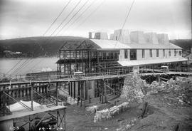
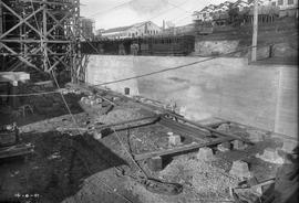
View downhill to River Derwent from E.Z. Co. Zinc Works 100-Ton Plant construction site
Fait partie de Photographs of E.Z. Co. Zinc Works at Risdon
Black-and-white photograph shows view dowhill to River Derwent looking across construction site of E.Z. Co. Zinc Works construction site of 100-Ton Plant
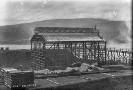
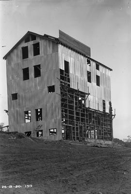
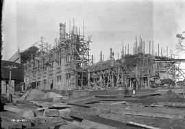
Workers building framework of new building at E.Z. Co Zinc Works 1924
Fait partie de Photographs of E.Z. Co. Zinc Works at Risdon
Black-and-white photograph shows piles of sawn timber, scaffolding and workers constructing the framework of a new building on an elevated site at the E.Z. Co. Zinc Works 1924
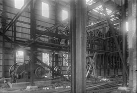
Workers pause for photo inside new building at E.Z. Co Zinc Works 1924
Fait partie de Photographs of E.Z. Co. Zinc Works at Risdon
Black-and-white photograph shows construction workers pausing for a photograph inside a new building at E.Z. Co. Zinc Works at Risdon 1924
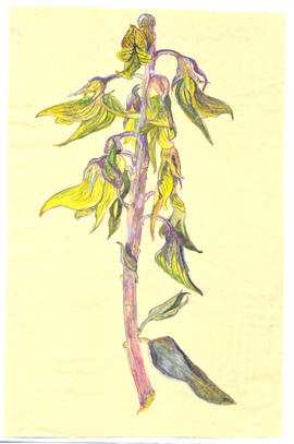
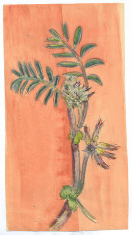
Fait partie de Olive Pink Collection
Water colour on paper sketched by Olive Pink, (place and date unknown) Northern Territory. Identified by Olive Pink as Crotalaria cunninghamii
Olive Pink
Fait partie de Olive Pink Collection
Water colour on card sketched by Olive Pink, (place and date unknown) Northern Territory. Not identified by Olive Pink
Olive Pink
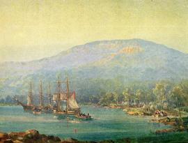
First Landing, printed reproduction of painting, coloured
Fait partie de George Musgrave Parker : Correspondence and research records
Printed reproduction of a painting of the First Landing in Van Diemens Land showing Mt. Wellington in the background
George Musgrave Parker