- AU TAS UTAS SPARC DX8-14
- Pièce
- c1950
Fait partie de Donald Davie Papers
Map of Tasmania c 1950. - 8 miles: 1 ins.
Donald Davie

2 résultats avec objets numériques Afficher les résultats avec des objets numériques
Fait partie de Donald Davie Papers
Map of Tasmania c 1950. - 8 miles: 1 ins.
Donald Davie
Collection consists of diaries, letters, maps, photographs and slides compiled during a tour of duty as a medical officer at RNZAF Station Torokina, Bougainville from June- November 1945.
Roland Arnold Rodda
Fait partie de Roland Rodda Collection
Maps produced and published by the Australian Survey Corps dated 1944-1945
1.Solomon Islands North Navigation Chart
2.Bougainville Island North
3.Bougainville Island South
4.Bougainville Island Cape Moltke
5.Bougainville Island Aita
6.Bougainville Island Inus
7.Bougainville Island Torokina
Roland Arnold Rodda
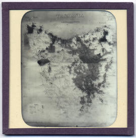
Fait partie de Walker Family Papers
Lantern slide of maps of Tasmania. Prepared by J.W. Beattie (1859-1930) whose studio locations were Elizabeth Street, Hobart from 1891-1920, Murray Street from 1921-40 and Cat and Fiddle until 1994.
John Watt Beattie
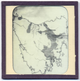
Fait partie de Walker Family Papers
Lantern slide of maps of Tasmania. Prepared by J.W. Beattie (1859-1930) whose studio locations were Elizabeth Street, Hobart from 1891-1920, Murray Street from 1921-40 and Cat and Fiddle until 1994.
John Watt Beattie