- AU TAS UTAS ITCCD 2017/2-1
- Unidad documental simple
- 1960s
Parte deArthur Knight Slides
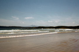
Colour photograph taken from beach at Cloudy Bay on Bruny Island, looking west to Adamsons Peak on Tasmanian mainland
Parte deArthur Knight Slides
Colour photograph taken from beach at Cloudy Bay on Bruny Island, looking west to Adamsons Peak on Tasmanian mainland
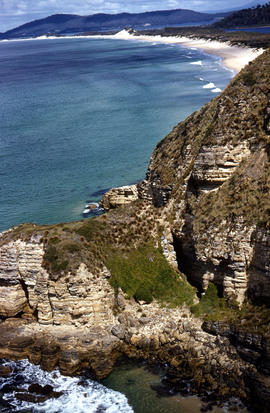
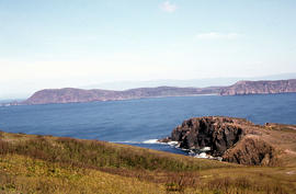
Adventure Bay near Cape Queen Elizabeth
Parte deArthur Knight Slides
View from headland of Adventure Bay near Cape Queen Elizabeth on Bruny Island.
Arthur Knight
Parte deArthur Knight Slides
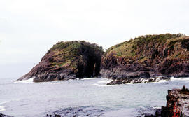
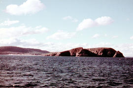
Arch island on Bruny Island
Arthur Knight
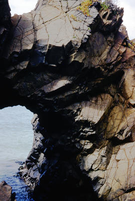
Cape Elizabeth arch on North Bruny Island
Parte deArthur Knight Slides
Colour photograph of archway at Cape Elizabeth on shoreline at North Bruny Island
Arthur Knight
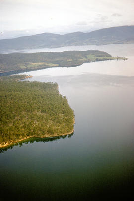
Aerial picture of Barnes Bay, 1950s
Parte deArthur Knight Slides
Aerial photograph of Barnes Bay on eastern side of Bruny Island.
View of Cape Connella from sea level
Parte deArthur Knight Slides
Colour photograph shows Cape Connella taken at sea level
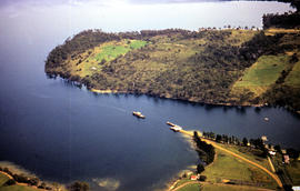
Aerial picture of boat in Barnes Bay
Parte deArthur Knight Slides
Colour photograph from the air showing a boat in Barnes Bay approaching or leaving jetty.
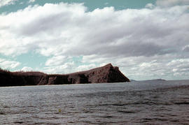
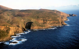
View of Cape Bruny and lighthouse from Lighthouse Bay
Parte deArthur Knight Slides
Colour photograph of waves breaking in Lighthouse Bay, with cliffs and headland of Cape Bruny and Bruny Island Lighthouse in background. Discolouration in scanned image from original slide.
View of Cape Bruny and lighthouse from Lighthouse Bay
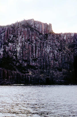
Parte deArthur Knight Slides
Colour photograph of cliffs of Cape Connella, South Bruny Island
View of Cape Connella from sea level
Parte deArthur Knight Slides
Colour photograph of Cape Connella, viewed from sea level several hundred metres offshore
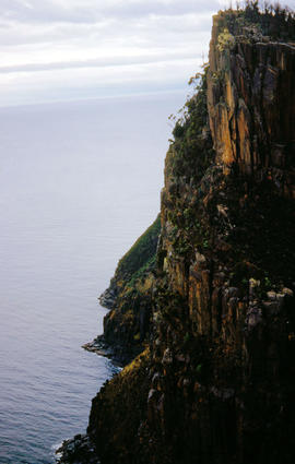
View of shoreline at base of Cape Connella, looking down cliff face
Parte deArthur Knight Slides
Colour photograph of shoreline at base of Cape Connella, South Bruny Island, looking down the cliff face.
Parte deArthur Knight Slides
Colour photograph, taken at sea, looking towards Cape Queen Elizabeth, Bruny Island
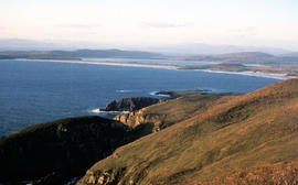
View of Cloudy Bay and West Cloudy Bay
Parte deArthur Knight Slides
Colour photograph of Cloudy Bay and West Cloudy Bay, Bruny Island.
View of Cloudy Bay from East Cloudy Head
Parte deArthur Knight Slides
Colour photograph of Cloudy Bay from East Cloudy Head
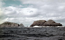
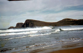
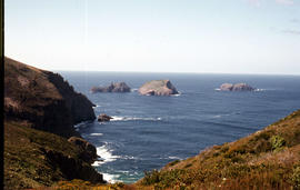
View of the Friars, off South Bruny Island
Parte deArthur Knight Slides
Colour photograph of Friars island group
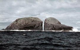
Gap between two Friars, off Bruny Island, 1962
Parte deArthur Knight Slides
Colour photograph taken at sea level of the gap between vertical cliffs of two islands in the Friars island group, off the southern coast of Bruny Island
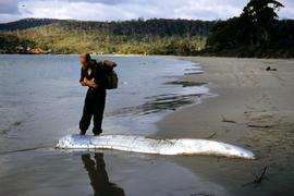
Man inspects ribbon fish on beach
Parte deArthur Knight Slides
Colour photograph of man looking at ribbonfish washed up on beach at Adventure Bay, Bruny Island
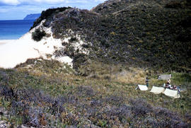
View of Bruny Island campsite of Hobart Walking Club 1955
Parte deArthur Knight Slides
Colour photograph of heath and sand dunes, site of Hobart Walking Club campsite near Cape Queen Elizabeth on Bruny Island,1955
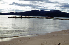
Section of old bridge at Alonnah
Parte deArthur Knight Slides
Colour photograph of old Hobart Bridge section tethered offshore at Alonnah

Staircase in Bruny Island Lighthouse
Parte deArthur Knight Slides
Colour photograph taken inside Bruny Island Lighthouse showing metal staircase
Setting sun shines on headland east of Cloudy Bay
Parte deArthur Knight Slides
Colour photograph of headland east of Cloudy Bay, illuminated by low setting sun.
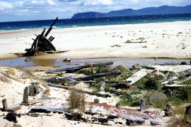
Wreck on beach near Mars Bluff
Parte deArthur Knight Slides
Colour photograph of rotting timbers from wreck of boat, half-buried in the sand near shallow creek on beach near Mars Bluff, Bruny Island, Photograph possibly taken 1963.
View of the Friars from shore near Pine Log Bight
Parte deArthur Knight Slides
Colour photograph of the Friars, a small group of islands, off southern shore of Bruny Island, taken from shore near Pine Log Bight.
Parte deArthur Knight Slides
Colour photograph shows snow-covered slope on Ben Lomond
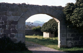
Parte deArthur Knight Slides
Colour photograph of stone archway at Bona Vista estate at Avoca, with view of mountains in the background Source: https://ehivecom/collections/4357/objects/180139/bona-vista-avoca-tasmania
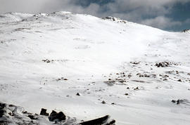
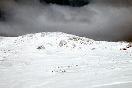
Aftermath of blizzard on Ben Lomond
Parte deArthur Knight Slides
Colour photograph shows snow on the upper slopes of Ben Lomond after a blizzard

Parte deArthur Knight Slides
Colour photograph of Bare Mountain, with evidence of past bushfire damage to trees on lower slope GIS: Latitude -4149 Longitude 14590 Gazetteer Australia Record_ID TAS23466
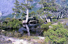
Trees reflected in Artists Pool
Parte deArthur Knight Slides
Colour photograph of Artists Pool, a waterhole near Cradle Mountain, with reflections of alpine plants on the water's surface

Parte deArthur Knight Slides
Colour photograph shows a person pointing at a dead bird on the ground near Bare Mountain, with new undergrowth shooting after a recent bushfire and several bushwalkers visible in the distance

Parte deArthur Knight Slides
Colour photograph of two walkers trying to avoid slippery pathway with flecks of snow on ground and Barn Bluff in background
Parte deArthur Knight Slides
Colour photograph of Barn Bluff and Cradle Cirque
Parte deArthur Knight Slides
Colour photograph shows heavy snow cover on Mount Barrow with man carrying skis next to guideposts alongside road

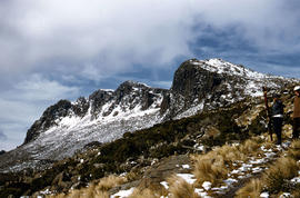
Barn Bluff as viewed from Cradle Mountain
Parte deArthur Knight Slides
Colour photograph of Barn Bluff as viewed form Cradle Mountain with some snow remaining on the ridgelines of the cirque
Parte deArthur Knight Slides
Colour photograph shows snow on Ben Lomond

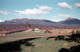
Parte deArthur Knight Slides
Colour photograph shows open paddock and mature eucalypt trees with Ben Lomond in the distance

Parte deArthur Knight Slides
Colour photograph of Carr Villa ski lodge at base of Ben Lomond
Parte deArthur Knight Slides
Colour photograph shows Ben Lomond plateau with partial snow cover and blackened ground
Parte deArthur Knight Slides
Colour photograph of snow skiers on Ben Lomond

Black jay perches on dozer at Cradle Mountain
Parte deArthur Knight Slides
Colour photograph shows a black jay perched on exhaust pipe of a John Deere earthmoving machinery near Waldheim Chalet car park at Cradle Mountain
Parte deArthur Knight Slides
Colour photograph shows open farmland in the foothills of Ben Lomond
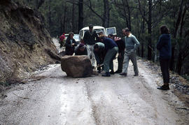
Boulder blocks Storeys Creek Rd 1964
Parte deArthur Knight Slides
Colour photographs shows motorists trying to clear a boulder from Storeys Creek Road after a rock fall
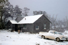
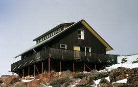
Carr Villa Chalet at Ben Lomond 1962
Parte deArthur Knight Slides
Colour photograph shows two people inspecting a gas cylinder outside the Carr Villa Chalet atop the treeline at Ben Lomond

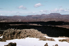
Central Highlands from cirque ridgeline
Parte deArthur Knight Slides
Colour photograph shows mountains from the Cirque near Cradle Mountain

Central Highlands from Cradle Mountain
Parte deArthur Knight Slides
Colour photograph shows mountains of Central Highlands as viewed from Cradle Mountain

Chalice Lake and Mount Rogoona
Parte deArthur Knight Slides
Colour photograph of Chalice Lake and Mount Rogoona GIS: Latitude -4188 Longitude 14619 Gazetteer Record_ID TAS02032

Parte deArthur Knight Slides
Colour photograph shows cliffs near Stacks Bluff

Misty morning at Cloister Lagoon
Parte deArthur Knight Slides
Colour photograph shows mist above the surface of Cloister Lagoon just before daybreak

Parte deArthur Knight Slides
Colour photograph shows shoreline of Cloister Lagoon GIS: Latitude -4189 Longitude 14617 Gazetteer Australia Record_ID TAS02046

Parte deArthur Knight Slides
Colour photograph shows Lake Lea in foreground, with Cradle Mountain and Barn Bluff in distance

Reflection of mountain on surface of Dove Lake
Parte deArthur Knight Slides
Colour photograph shows light dusting of snow on Cradle Mountain, visible also from reflection in Dove Lake in foreground

Parte deArthur Knight Slides
Colour photograph shows flecks of snow on upper ridges of Cradle Mountain and land around Dove Lake, some of it cloaked in deep shadow

Reflection of mountain on still surface of Dove Lake
Parte deArthur Knight Slides
Colour photograph shows reflection of Cradle Mountain on surface of Dove Lake Image of mountain slightly out of focus

Looking south to Cradle Mountain
Parte deArthur Knight Slides
Colour photograph shows the heathland on the Central Plateau, south of Cradle Mountain, with the mountain peaks visible in the distance

View of Cradle Mountain ridgeline from Hansons Peak
Parte deArthur Knight Slides
Colour photograph of Cradle Mountain from Hansons Peak

Cradle Mountain from Dove Lake
Parte deArthur Knight Slides
Colour photograph shows light dusting of snow on Cradle Mountain from Dove Lake

Cradle Mountain from Hansons Peak
Parte deArthur Knight Slides
Colour photograph of Cradle Mountain as viewed from nearby Hansons Peak

Parte deArthur Knight Slides
Colour photograph shows ridge of rock from Dove Lake
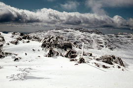
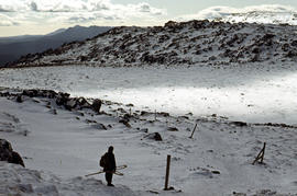
Snow cover on Ben Lomond Plateau
Parte deArthur Knight Slides
Colour photograph shows snow cover on Ben Lomond Plateau

Pencil Pines on shore of Crater Lake
Parte deArthur Knight Slides
Colour photograph shows Crater Lake, with remnants of snow on rock ledge

Parte deArthur Knight Slides
Colour photograph shows shoreline of Crater Lake with sunlit cliffs on opposite bank

Parte deArthur Knight Slides
Colour photograph shows a steel-plated culvert beneath a road at Foggs Flat

Parte deArthur Knight Slides
Colour photograph shows Crater Lake

Parte deArthur Knight Slides
Colour photograph shows bed of green and red cushion plants

Parte deArthur Knight Slides
Colour photograph shows bed of green cushion plants

Parte deArthur Knight Slides
Colour photograph shows two sets of skis and backpacks outside an alpine hut, covered in a snowdrift

Alpine hut covered in snowdrift
Parte deArthur Knight Slides
Colour photograph shows footprints in snow leading to an alpine hut in a clearing, partially covered by snowdrift
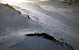
Parte deArthur Knight Slides
Colour photograph shows wind moving snow in drift at sunset on Ben Lomond 1962

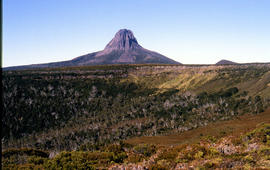
Du Cane Range from Mountains of Jupiter
Parte deArthur Knight Slides
Colour photograph shows Du Cane Range as viewed from Mountains of Jupiter
Snowdrift against rocks at Ben Lomond
Parte deArthur Knight Slides
Colour photograph shows snowdrift against rocks on Ben Lomond 1962

Du Cane Range and Mount Ossa under snow
Parte deArthur Knight Slides
Colour photograph of Du Cane Range and Mount Ossa

Parte deArthur Knight Slides
Colour photograph shows alpine plateau, valley and Eldon and Tyndall ranges in distance

Parte deArthur Knight Slides
Colour photograph shows Volkswagen combi van being driven through floodwaters across Midland Highway 1964
Parte deArthur Knight Slides
Colour photograph shows Foresters hut on Ben Lomond 1977

Wildflowers on Cathedral Mountain
Parte deArthur Knight Slides
Colour photograph of wildflower in alpine environment

Parte deArthur Knight Slides
Colour photograph shows Grail Falls
Parte deArthur Knight Slides
Colour photograph shows three snow skiers on Ben Lomond 1977

Parte deArthur Knight Slides
Colour photograph shows hut at Lake Meston built of logs, shingles and with tin plate chimney People sitting outside hut eating

Snow on banks of River Derwent 1986
Parte deArthur Knight Slides
Colour photograph shows snow on the shoreline of River Derwent 1986

Parte deArthur Knight Slides
Colour photograph shows ice formed on plants, location unknown
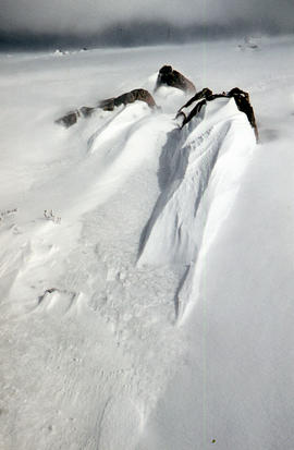
Ice formation on rocks at Ben Lomond 1962
Parte deArthur Knight Slides
Colour photograph shows ice formation on rocks atop Ben Lomond 1962

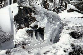
Ice formation near Herods Gate 1978
Parte deArthur Knight Slides
Colour photograph shows ice formation on cliff face near Herods Gate, with snow covering alpine vegetation

Parte deArthur Knight Slides
Colour photograph shows icicles formed on Little Horn 1985

Snowfall at Jaffa Vale and Mount Olympus
Parte deArthur Knight Slides
Colour photograph shows tracks of snow skiers at Jaffa Vale and Mount Olympus

Parte deArthur Knight Slides
Colour photograph shows snow at Jaffa Vale

Parte deArthur Knight Slides
Colour photograph of limited water flow across Knyvet Falls 1984 GIS: Latitude -4159 Longitude 14593 Gazetteer Australia Record_ID TAS06008

Parte deArthur Knight Slides
Colour photograph shows shoreline of Lake Adelaide

Lake Lea from Prospect Mountain
Parte deArthur Knight Slides
Colour photograph shows Lake Lea from Prospect Mountain near Vale of Belvoir

Reflections upon surface of Lake Chalice 1979
Parte deArthur Knight Slides
Colour photograph shows reflections of alpine vegetation in Chalice Lake 1979 GIS: Lake Latitude -4188 Longitude 14615 Gazetteer Australia Record_ID TAS02044

Lake Loane under snow cover 1978
Parte deArthur Knight Slides
Colour photograph shows Lake Loane beneath blanket of snow, from near the Horse Track 1978

Shoreline of Lake Chalice 1979
Parte deArthur Knight Slides
Colour photograph shows the rocky shoreline of Chalice Lake GIS: Latitude -4188 Longitude 14615 Gazetteer Australia Record_ID TAS02044

Parte deArthur Knight Slides
Colour photograph shows waves and white caps on the surface of Lake Myrtle GIS: Latitude -4188 Longitude 14618 Gazetteer Australia Record_ID TAS02073
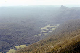
Lees Paddock and Mount Pillinger
Parte deArthur Knight Slides
Colour photograph shows the cleared land of Lees Paddocks in the upper Mersey Valley, surrounded by bush with Mount Pillinger in the background
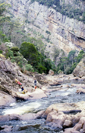
Sitting on ledge beside Leven River
Parte deArthur Knight Slides
Colour photograph shows walkers resting on rock ledge beside Leven River in the Leven Canyon
Parte deArthur Knight Slides
Colour photograph shows Legges Tor, the highest peak of Ben Lomond, with skiers visible on the nearby ski field
Parte deArthur Knight Slides
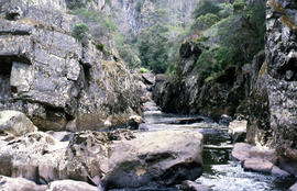
Colour photograph shows rockpools in the Leven River at Leven Canyon, surrounded by steep rockwalls and temperate rainforest
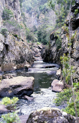
Portrait format photograph of Leven Canyon
Parte deArthur Knight Slides
Colour portrait format photograph shows Leven River spilling in to narrow gorge in the part of the river known as Leven Canyon

Parte deArthur Knight Slides
Colour portrait format photograph shows Lake Wilks and Little Horn near Cradle Mountain
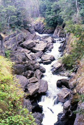
Parte deArthur Knight Slides
Colour photograph shows whitewater in narrow section of Leven Canyon
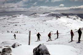
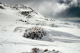
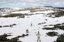
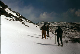
Snow skiers on Ben Lomond 1962
Parte deArthur Knight Slides
Colour photograph shows snow skiing on Ben Lomond at Markham Heights
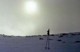
Morning mist on Ben Lomond 1962
Parte deArthur Knight Slides
Colour photograph shows pair of gloves on a set of ski poles pitched into snow atop Ben Lomond, with mist covering the sun