- AU TAS UTAS ITCCD 2017/2-188
- Unidad documental simple
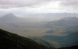
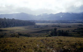
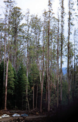
Parte deArthur Knight Slides
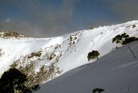
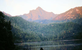
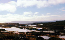
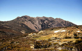
Colour photograph taken from elevated mountain ridge, shows valley floor looking west to Mount Solitary and original shoreline of Lake Pedder
Parte deArthur Knight Slides
Colour photograph taken from elevated mountain ridge, shows valley floor looking west to Mount Solitary and original shoreline of Lake Pedder
Walkers on ridge overlooking Mount Solitary
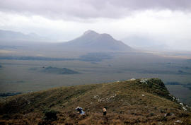
Parte deArthur Knight Slides
Colour photograph shows some bushwalkers on a ridge overlooking the valley towards Mount Solitary
Mural in Hobart Walking Club hut
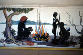
Parte deArthur Knight Slides
Colour photograph shows a mural in the Hobart Walking Club hut at Lake Dobson Source
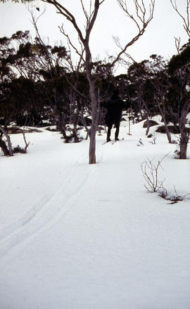
Parte deArthur Knight Slides
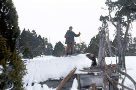
Colour photograph shows snow skiers on Mount Mawson, one using a tow rope to climb uphill
Signs at entrance to Mount Field National Park
Parte deArthur Knight Slides
Colour photograph shows signs posted at entrance of Mount Field National Park, with distances and estimated travel times to Lake Dobson (9 1/4 miles), Lake Fenton (7 1/4 miles), Lady Barron Falls (1 1/2 mile), Camping Ground (250 yds), Rangers Cottage (150 Yds), Russell Falls 1/2 MILE 10 MIN, Lady Barron Falls Round Trip 3 1/2 MILES 1H 45 MIN
Parte deArthur Knight Slides
Colour photograph shows snow covering Tarn Shelf in Mount Field National Park
Marker on South Gordon walking track
Parte deArthur Knight Slides
Colour photograph shows unusual sign for South Gordon walking track turnoff, fashioned out of number plates, with three backpacks resting on ground nearby
Paddler in the Cruncher at Bradys Lake
Parte deArthur Knight Slides
Colour photograph shows a paddler of a kayak in the Cruncher a segment of water on the Bradys Lake whitewater course
Parte deArthur Knight Slides
Colour photograph shows rusted International Harvester locomotive on disused rails covered with bracken in a semi-cleared area of land
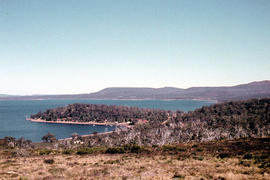
Shoreline of Great Lake at Breona
Parte deArthur Knight Slides
Colour photograph depicts northern shoreline of Great Lake and settlement of Breona
Arthur Knight
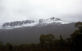
Snow cover on Mount Olympus above Lake St Clair
Parte deArthur Knight Slides
Colour photograph shows snow above the treeline on Mount Olympus
Arthur Knight
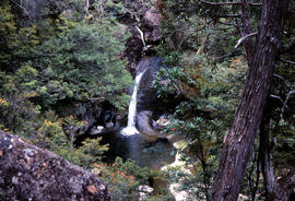
Waterfall on track to Meander Valley Falls
Parte deArthur Knight Slides
Colour photograph shows water spilling into a pool beside track to Meander Falls, with overhanging trees and vegetation surrounding stream
Arthur Knight
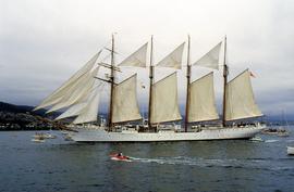
Spanish training ship Juan Sebastian de Elcano on Derwent
Parte deHal Wyatt Collection
Colour photograph of the Spanish Armada training ship Juan Sebastian de Elcano, a four-masted barque, sailing on the Derwent River during the Tall Ships event held in 1988
Golden Stairs ski run at Mount Mawson
Parte deHal Wyatt Collection
Colour photograph of snow on the Golden Stairs, a ski run near Mount Field
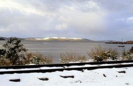
Snow on Hobart waterfront 1986
Parte deHal Wyatt Collection
Colour photograph of snow on railway tracks on shore of Derwent River 1986
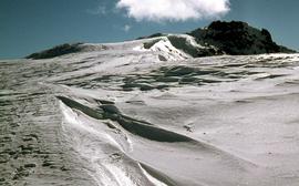
Parte deHal Wyatt Collection
Colour photograph of waves of ice, known as sastrugi, formed near the top of Naturalist Peak, photographed in 1971
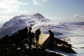
Campsite near snow-capped summit of Florentine Peak
Parte deHal Wyatt Collection
Colour photograph shows three people standing outside a canvas tent pitched near the snow-capped summit of Florentine Peak
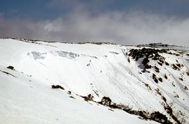
Climbers near site of avalanches
Parte deHal Wyatt Collection
Colour photograph of party of snow climbers nearing a ridge with evidence of recent avalanches, possibly near Mount Field National Park, photograph taken 1968
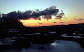
Sunset at Newdegate Pass, 1969
Parte deHal Wyatt Collection
Colour photograph of setting sun behind mountains at Newdegate Pass, 1969
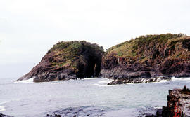
Parte deArthur Knight Slides
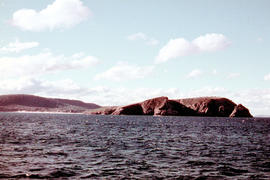
Arch island on Bruny Island
Arthur Knight
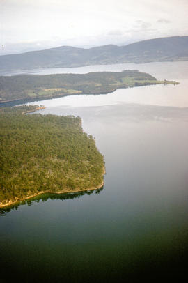
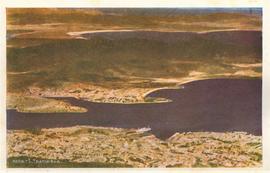
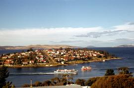
Aerial picture of Barnes Bay, 1950s
Parte deArthur Knight Slides
Aerial photograph of Barnes Bay on eastern side of Bruny Island.
Parte deArthur Knight Slides
Colour photograph, taken at sea, looking towards Cape Queen Elizabeth, Bruny Island
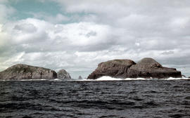
View of the Friars, off South Bruny Island
Parte deArthur Knight Slides
Colour photograph of Friars island group
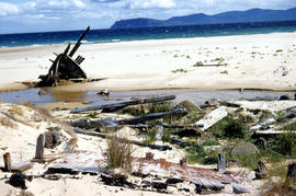
Wreck on beach near Mars Bluff
Parte deArthur Knight Slides
Colour photograph of rotting timbers from wreck of boat, half-buried in the sand near shallow creek on beach near Mars Bluff, Bruny Island, Photograph possibly taken 1963.

Parte deArthur Knight Slides
Colour photograph of Bare Mountain, with evidence of past bushfire damage to trees on lower slope GIS: Latitude -4149 Longitude 14590 Gazetteer Australia Record_ID TAS23466

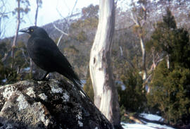
Black jay perches on dozer at Cradle Mountain
Parte deArthur Knight Slides
Colour photograph shows a black jay perched on exhaust pipe of a John Deere earthmoving machinery near Waldheim Chalet car park at Cradle Mountain

Central Highlands from cirque ridgeline
Parte deArthur Knight Slides
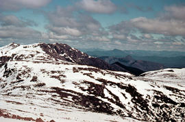
Colour photograph shows mountains from the Cirque near Cradle Mountain

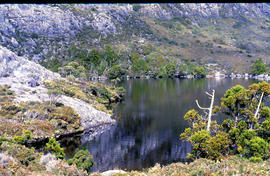
Chalice Lake and Mount Rogoona
Parte deArthur Knight Slides
Colour photograph of Chalice Lake and Mount Rogoona GIS: Latitude -4188 Longitude 14619 Gazetteer Record_ID TAS02032

View of Cradle Mountain ridgeline from Hansons Peak
Parte deArthur Knight Slides
Colour photograph of Cradle Mountain from Hansons Peak

Parte deArthur Knight Slides
Colour photograph shows a steel-plated culvert beneath a road at Foggs Flat

Parte deArthur Knight Slides
Colour photograph shows two sets of skis and backpacks outside an alpine hut, covered in a snowdrift

Du Cane Range from Mountains of Jupiter
Parte deArthur Knight Slides
Colour photograph shows Du Cane Range as viewed from Mountains of Jupiter

Du Cane Range and Mount Ossa under snow
Parte deArthur Knight Slides
Colour photograph of Du Cane Range and Mount Ossa

Parte deArthur Knight Slides
Colour photograph shows Grail Falls

Parte deArthur Knight Slides
Colour photograph shows ice formed on plants, location unknown

Parte deArthur Knight Slides
Colour portrait format photograph shows Lake Wilks and Little Horn near Cradle Mountain

Walkers on Mountains of Jupiter
Parte deArthur Knight Slides
Colour photograph of bushwalkers at Mountains of Jupiter near the Walls of Jerusalem
Parte deArthur Knight Slides
Colour photograph shows Mount Anne at sunrise as viewed from across Lake Timk

Mount Geyron from Cathedral Mountain
Parte deArthur Knight Slides
Colour photograph shows Lake Payanna and Mount Ida
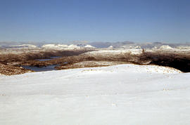
Snow cover at near Walls of Jerusalem looking to Mount Olympus and Mount Gould
Parte deArthur Knight Slides
Colour photograph shows snow skier standing on Mount Jerusalem
Parte deArthur Knight Slides
Colour photograph shows whitewater section of Pencil Pine Creek
Pencil Pines near Dixons Kingdom
Parte deArthur Knight Slides
Colour photograph shows Piesse Vale at Ben Lomond plateau dusted with snow GIS Latitude -4154 Longitude 14763 Gazetteer Record_ID TAS13722
Parte deArthur Knight Slides
Colour photograph shows creek running through snow and ice on plateau above Cradle Mountain
Parte deArthur Knight Slides
Colour photograph shows snow covering the Pool of Siloam near The Temple below Mount Jerusalem
Skiing on the roof of Dixons Kingdom
Parte deArthur Knight Slides
Colour photograph shows buildings on Ben Lomond
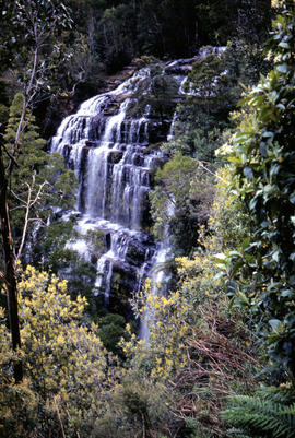
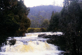
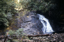
Small waterfall above Grail Falls
Parte deArthur Knight Slides
Colour photograph shows snow formation at Jaffa Gate
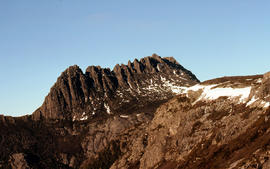
Summit of Cradle Mountain 1976
Parte deArthur Knight Slides
Colour photograph shows summit of West Wall, at Mount Jerusalem
The Temple near Mount Jerusalem
Parte deArthur Knight Slides
Colour photograph shows snow cover along the Wailing Wall near Mount Jerusalem
The Temple and Mount Jerusalem 1978
Parte deArthur Knight Slides
Colour photograph shows the Temple near Mount Jerusalem

Parte deArthur Knight Slides
Colour photograph shows alpine vegetation and snowcover below Mount Ophel
Waterfall at western end of Lake Timk 1974
Parte deArthur Knight Slides
Colour photograph shows West Wall

Parte deArthur Knight Slides
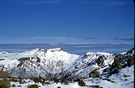
Colour photograph shows snow cover surround Lake Thor and Western Bluff
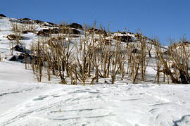
Dead alpine trees in snow at Wailing Wall
Parte deArthur Knight Slides
Colour photograph shows impact of bushfire that left dead vegetation in an alpine area at the Wailing Wall
Parte deArthur Knight Slides
Colour photograph shows a black jay, or black currawong, resting on a rock near Lake Dobson
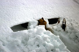
Parte deArthur Knight Slides
Colour photograph shows person excavating blocks of snow to build a snow cave
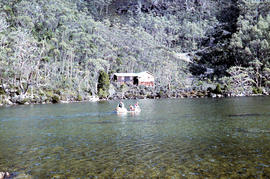
Moving firewood at Lake Dobson
Parte deArthur Knight Slides
Colour photographs shows three people in a small boat laden with firewood being moved from one side of Lake Dobson to another. Hut visible on shore and cleared path of zig-zag track up hill visible in background
Parte deArthur Knight Slides
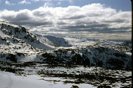
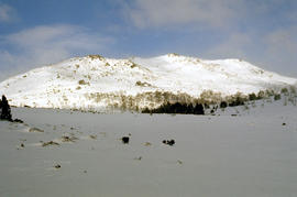
Colour photograph shows snow cover on Florentine Peak
Parte deArthur Knight Slides
Colour photograph shows ridge line of Florentine Peak, with small patches of snow in foreground
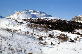
Parte deArthur Knight Slides
Colour photograph shows partial snow cover on Florentine Peak, looking west across mountains in distance
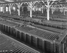
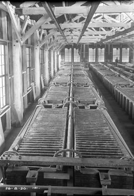
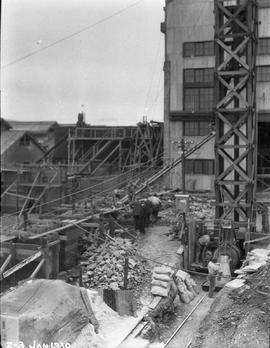
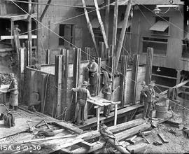
Cell room in the 100-ton plant
Black-and-white photograph shows the newly constructed cell room inside the 100-Ton plant at E.Z. Co. Zinc Works at Risdon, with Johns and Waygood stencilled on the overhead gantry
Interior of cell room at E.Z. Co. Zinc Works
Black-and-white photograph shows interior of cell room at E.Z. Co. Zinc Works at Risdon
Black-and-white photograph shows sawmill, timber and unsawn logs being used for construction of new plant at E.Z. Co. Zinc Works at Risdon
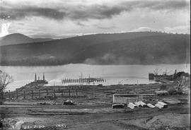
Construction of new wharf at E.Z. Co. Zinc Works
Black-and-white photograph shows construction of new wharf at E.Z. Co. Zinc Works at Risdon
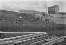
Horse carts and timber at E.Z. Co. Zinc Works
Black-and-white photograph shows stacks of sawn timber and workmen with horses and carts removing earth at an excavation on site E.Z. Co. Zinc Works at Risdon
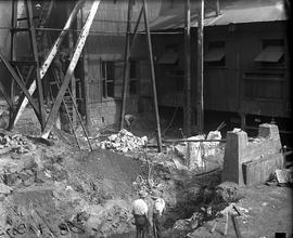
Power house foundation work at E.Z. Co. Zinc Works
Black-and-white photograph shows foundation of power house 4th unit being built at E.Z. Co. Zinc Works at Risdon
Looking north to cell room extension at E.Z. Co. Zinc Works
Black-and-white photograph of construction of cell room extension at E.Z. Co. Zinc Works at Risdon. Large sign reading “SAFETY” is mounted at ground level.
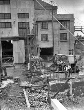
Workmen preparing footings for expansion at E.Z. Co. Zinc Works at Risdon
Black-and-white photograph depicts workmen preparing footings for expansion of power house at E.Z. Co. Zinc Works at Risdon
Excavation work for construction of furnace at E.Z. Co. Zinc Works
Black-and-white photograph shows workmen beginning excavation of site for new Derwent Prime furnace
Derwent Prime furnace jacket assembled at E.Z. Co. Zinc Works
Black-and-white photograph shows men assembling Derwent Prime furnace at E.Z. Co. Zinc Works at Risdon
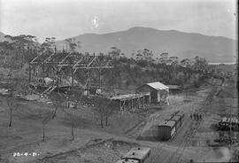
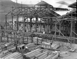
Framework of roasting division building at E.Z. Co. Zinc Works at Risdon
Black-and-white photograph shows framework and construction of roasting division building at E.Z. Co. Zinc Works at Risdon, above railway line, with stockpile of logs and timber above railway cutting; Mount Faulkner in background
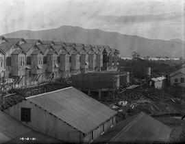
Black-and-white photograph shows an elevated view of the cell room building, the roasting division and other buildings under construction, looking west, with Mount Faulkner in the background 1921
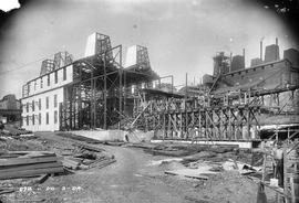
View of construction site uphill at E.Z. Co. Zinc Works at Risdon 1924
Black-and-white photograph shows view of new building on site, looking uphill, at E.Z. Co. Zinc Works at Risdon 1924
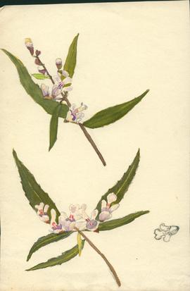
Parte deOlive Pink Collection
Sketch of a Mint bush
Olive Pink
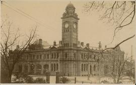
Parte deGeorge Musgrave Parker : Correspondence and research records
Postcard by D.I.C. Photo of the Post Office, Hobart, taken from Franklin Square
George Musgrave Parker
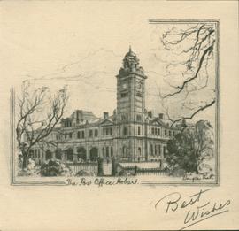
Parte deGeorge Musgrave Parker : Correspondence and research records
Small pencil sketch the Post Office, Hobart, by Douglas Pratt
George Musgrave Parker
Parte deGeorge Musgrave Parker : Correspondence and research records
(Mrs Mitchell). See also book chap. 9 (P1/35 (26-)
George Musgrave Parker

Parte deGeorge Musgrave Parker : Correspondence and research records
George Musgrave Parker
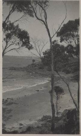
Coast view: East Coast Rocky Hills
Parte deGeorge Musgrave Parker : Correspondence and research records
Thought to be Rocky Hills
George Musgrave Parker
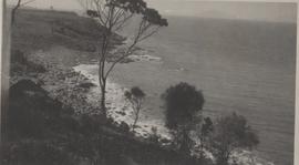
East Coast, view from Rocky Hills looking north
Parte deGeorge Musgrave Parker : Correspondence and research records
near present Kabuki Restaurant
George Musgrave Parker
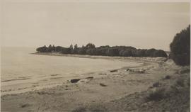
Parte deGeorge Musgrave Parker : Correspondence and research records
Photograph of Swansea Beach with Freycinet in distance
George Musgrave Parker
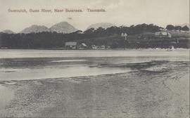
Parte deGeorge Musgrave Parker : Correspondence and research records
Post card of Swanwick, on the Swan River near Swansea, Tasmania. Depicts beach in foreground and farm in background. Spurling postcard.
George Musgrave Parker
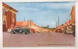
The Main Street, Huonville, Tas
Parte deDe La Haye Postcard Collection
Parte deDe La Haye Postcard Collection
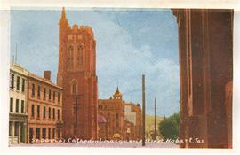
St. David's Cathedral, Macquarie Street, Hobart, Tasmania
Parte deDe La Haye Postcard Collection
Parte deDe La Haye Postcard Collection
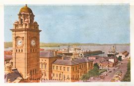
Wharves, Hobart, Tas., showing G.P.O. Tower
Parte deDe La Haye Postcard Collection
Parte deDe La Haye Postcard Collection
Dinghy on water in Barnes Bay 1960
Parte deHal Wyatt Collection
Colour photograph of three people in a dinghy, offshore at Barnes Bay, Bruny Island
Hal Wyatt
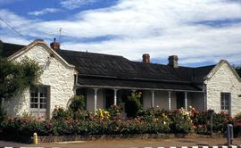
Rendered stone house at Bellerive with large floral garden
Parte deHal Wyatt Collection
Colour photograph of stone house at Bellerive, rendered or painted white, with flowers in bloom in front garden, in front of verandah, house old tin roof, on corner block, street pillar for PMG telephone cabling near letterbox
Hal Wyatt
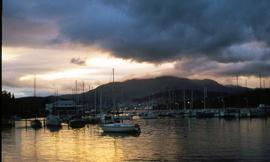
Parte deHal Wyatt Collection
Colour photograph taken at dusk, of Bellerive marina
Hal Wyatt
Parte deHal Wyatt Collection
Colour photograph shows two ferries travelling in opposite directions at Bellerive
Hal Wyatt
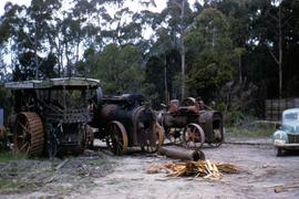
Parte deHal Wyatt Collection
Colour photograph of three steam engines in Best’s yard, Devonport, taken 1959; depicts three steam engines in a clearing in a eucalyptus bush setting with pile of scrap timber suitable for fuel and green motor vehicle.
Hal Wyatt
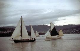
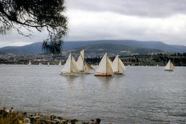
Yachts on river, one with black sail
Parte deHal Wyatt Collection
Colour photograph of three yachts under sail on Derwent River, one a ketch, has a black sail on the foremast.
Hal Wyatt
Rocky shoreline at blowhole, Bicheno
Parte deHal Wyatt Collection
Colour photograph of blowhole at Bicheno. Original filename misspells name of town as "Bichino".
Hal Wyatt
Boat race in Derwent River, 1954
Parte deHal Wyatt Collection
Colour photograph of single-masted yachts racing on Derwent River, 1954; people on rocky shore watching.
Hal Wyatt
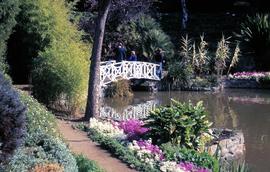
White bridge at botanical gardens
Parte deHal Wyatt Collection
Colour photograph shows people walking across white bridge, Royal Tasmanian Botanical Gardens, Queens Domain, Hobart.
Hal Wyatt
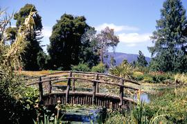
Timber bridge over pond at botanical gardens
Parte deHal Wyatt Collection
Colour photograph shows rustic timber bridge across a pond at Royal Tasmanian Botanical Gardens, Queens Domain, Hobart.
Hal Wyatt
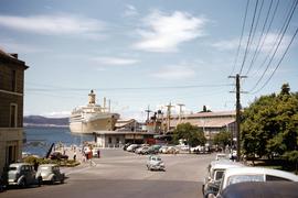
Murray Street ferry pier and ships docked in Hobart
Parte deHal Wyatt Collection
Colour photograph of ferry pier at bottom of Murray Street, Hobart, departure point for the Bellerive ferry; cargo and passenger ships docked at nearby Princes Wharf, including the steamer Orsova; sign advertising Cascade Ale on the Customs House Hotel.
Hal Wyatt
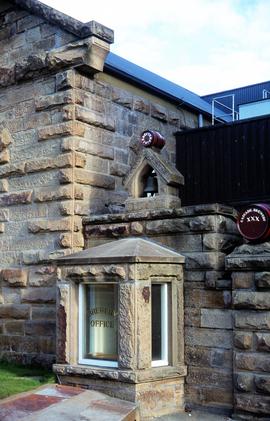
Office window at Cascade Brewery
Parte deHal Wyatt Collection
Colour photograph depicting facade of Cascade Brewery office, built in sandstone, with bell and decorative barrels mounted on roof, “Cascade Brewery XXX” and “Erected 1874”.
Hal Wyatt
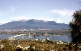
Tasman Bridge nears completion
Parte deHal Wyatt Collection
Colour photograph shows construction of Tasman Bridge, from Derwent River’s Eastern Shore. Shows spans of Tasman Bridge almost completed from Eastern Shore, temporary floating Hobart Bridge upstream of new multi-lane road bridge; snow on Mount Wellington in background. Printing or scanning error in photograph/slide shows coloured lines horizontally through. photograph.
Hal Wyatt