- AU TAS UTAS ITCCD 2017/18-0241
- Item
- 1940
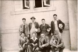
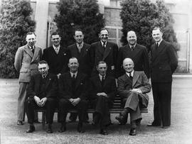
Group of men photographed outside a building.
Group of men photographed outside a building.
Group of men posing for photograph in grassed area.
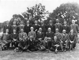
Group of men wearing suits and ties posing for photograph on lawn.
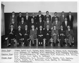
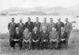
Group photograph. Left to right. Back: AJ Uglow, MG Wells, G Blay, AB Eastaugh, JS Oldrey, J McSwan, RV Harrison, RM Conway, DB Orr. Centre: RB Thistlethwayte, E Dewhurst, WA Hopkins, BA Moore, KG Woods, GJ Budd, D McEvoy. Front: DF MacKenzie, GS Essery, JWC Wyett, VG Burley, JPD Lloyd, HV McKernan, RA Smith, J Mitchell, WR Prendergast.
Group of men in business dress posing for photograph on lawn with water behind.
Group photograph, Cadbury Factory
Group photograph of men wearing suits, taken outside Cadbury factory Claremont.
Group photograph, Cadbury Factory
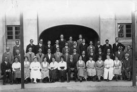
Large group of people photographed outside portion of the Cadbury building.
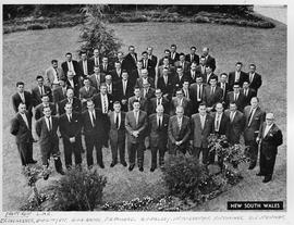
Group photograph, New South Wales Conference
Group photograph, New South Wales conference. Information available for front row only: J.F. Sedgebeer, J.N.C.Wyett, H.V.D. Brink, F.A. Pollard, R.V. Palesy, H.V. McKernan, F.W. Thomas, D.S. Newman
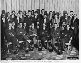
Group photograph, Queensland Conference
Group photograph, Queensland conference. Information available for front row only: N.E. Tilburn, D.S. Newman, B.C. Johnston, H.V. McKernan, A.J.V. Glow, J.W.C. Wyett
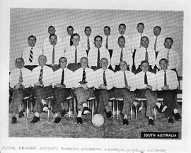
Group photograph, South Australian Conference
Group photograph, South Australian conference. Information available for front row only: F. Stock, R.B. Fisher, J.W.C. Wyett, A.H. Seaton, H. V. McKernan, W.A. Hopkins, M. G. Wells, L.S. Coker. Date of conference annotated on ball 1960.
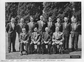
Group photograph, Tasmanian Conference
Group photograph, Tasmanian Conference. Information available for front row only. Left to right: JH Cooper, HC Partridge, AB Eastaugh, RS Poke
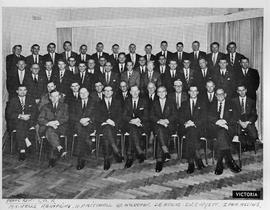
Group photograph, Victorian Conference
Group photograph, Victorian conference. Information available for front row only: M.G. Wells, W.A. Hopkins, N.F. Mitchell, H.V. McKernan, D.R. Atkins, J.W.C. Wyett, I. Van Assche
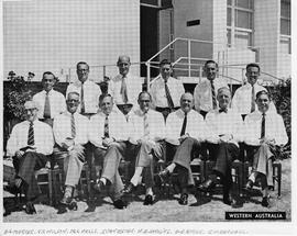
Group photograph, Western Australian Conference
Group photograph, Western Australian conference. Information available for front row only: A.G. Mercer, J.C. Wilson, M.G. Wells, I. van Assche, W.A. Hopkins, A.E. Burke, J,.W. Randall
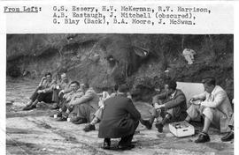
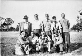
Group seated on ground taking a rest break
Group seated on ground drinking from cups, fruit in box. Left to right: GS Essery, HV McKernan, RV Harrison, AB Eastaugh, J Mitchell (obscured) G Blay (back) BA Moore, J McSwan.
Part of Arthur Knight Slides
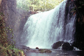
Colour photograph shows Guide Falls near Burnie, 1963
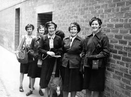
Black and white photograph of girl guides in uniform, taken in the 1950s.
Graeme Raphael
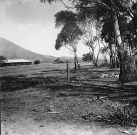
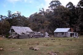
Clearing with gum trees at side, with long tin roofed building in distance.
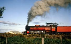
H Class locomotive steams slowly along at Perth
Part of Hal Wyatt Collection
Colour photograph shows Tasmanian Government Railways steam locomotive H3 on the tracks at Perth.
Hal Wyatt
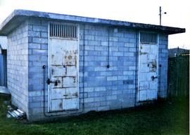
Small cement block building with two padlocked doors with grilles above.
Graeme Raphael
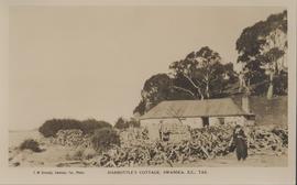
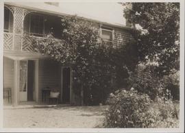
Harbottle's cottage at Swansea
Part of George Musgrave Parker : Correspondence and research records
Postcard produced by Swansea photographer, Miss F.M. Kennedy, (c1880-c1950s) of titled Harbottle's at Swansea, Tasmania.
This Cottage has also been know as Harbottle's Cottage and Caulfield Cottage. This single storey, sandstone rubble building with a corrugated iron hipped roof was listed by the National Trust in 1976 as it demonstrated the principal characteristics of a single storey, sandstone Victorian Georgian domestic building . Located at 45 Shaw Street, Swansea, Tasmania
George Musgrave Parker
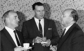
Three men wearing suits and ties, chatting over tea and coffee.
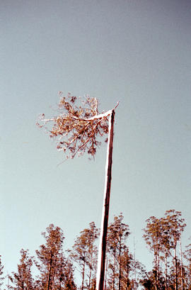
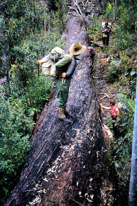
Heading a tree in the Florentine Valley
Part of Arthur Knight Slides
Colour portrait format photograph shows the head of a tall eucalypt tree falling when a timber worker chopped it down after scaling the three
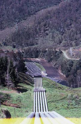
Headrace at Tarraleah Power Station
Colour photograph looking downhill to Tarraleah Power Station

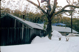
Heavy snowfall at Hobart Walking Club hut at Lake Dobson
Part of Hal Wyatt Collection
Colour photograph shows smoke curling from the chimney of the Hobart Walking Club hut at Lake Dobson after heavy snowfall
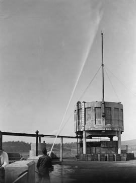
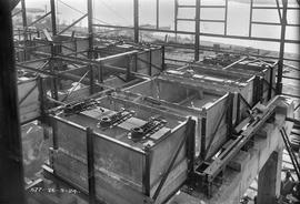
High Pressure Hose, Cadbury Factory
Large cement tank being sprayed with water by man holding high pressure fire hose.
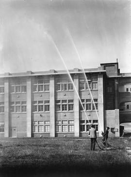
Two men spraying plumes of water into the air from high pressure fire hoses.
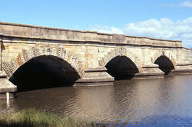
Part of Arthur Knight Slides
Colour photograph shows fast-flowing water of the Macquarie River at the Ross Bridge
Arthur Knight
Photograph of two-storey rendered house, Georgian in style, with trees, lawn and flower garden at front, behind fence with old lichen-covered fenceposts, strands of rusty barbed wire and wire mesh.
Graeme Raphael
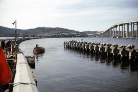
Hobart Bridge and Tasman Bridge
Part of Hal Wyatt Collection
Colour photograph taken from the western shore of the Derwent River, depicts vehicles travelling on the temporary, floating Hobart Bridge, while the nearly complete multi-lane Tasman Bridge to join the eastern and western shores of the river, is visible downstream.
Hal Wyatt
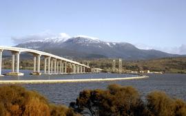
Hobart Bridge and Tasman Bridge in winter 1964
Part of Hal Wyatt Collection
Colour photograph of two bridges across the Derwent River, the Hobart Bridge, right, and the Tasman Bridge, left, as viewed from the eastern shore of the Derwent in August 1964. Snow caps Mount Wellington in the background.
Hal Wyatt
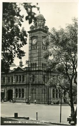
Hobart General Post Office from Franklin Park
Part of Photographs of Edward Verrell
Black-and-white photograph shows Hobart General Post Office viewed from Franklin Park. Words “G.P.O., HOBART, FROM FRANKLIN PARK” and “V6” are typewritten in black on white reverse panel at bottom of photograph
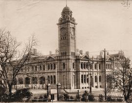
Hobart GPO before installation of clock in tower
Part of Photographs of Edward Verrell
Black-and-white photograph shows Hobart General Post Office viewed from Franklin Park before the installation of the clock in the clocktower.
Hobart Railway Station, taken from university gardens
Part of Photographs of Edward Verrell
Black-and-white photograph shows Hobart Railway Station, viewed from gardens of the University of Tasmania, including the Tasmanian Government Railways workshops
Part of Arthur Knight Slides
Colour photograph shows smoke curling out of the flue from a woodheater or fireplace of the Hobart Walking Club timber hut at Mount Field National Park, with snowdrifts banked halfway up the walls of the hut
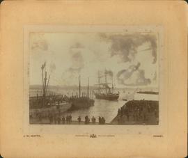
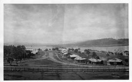
Hobart wharves, steam sail boats
Part of George Musgrave Parker : Correspondence and research records
Photograph of Hobart wharves showing steam sail boats taken by J.W. Beattie. The photograph does have some marks on it.
George Musgrave Parker
Part of De La Haye Postcard Collection
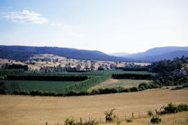
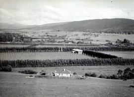
Hop fields and oast house near Rosegarland
Part of Arthur Knight Slides
Colour photograph shows hop fields, timber huts and oast house near Rosegarland
Part of Arthur Knight Slides
Colour photograph shows hop fields, farm buildings and dwellings at Glenora, 1959
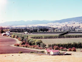
Part of Arthur Knight Slides
Colour photograph shows hop fields in at Glenora, 1959
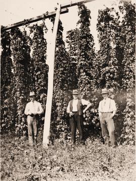
Black and white photograph of men in shirtsleeves, wearing hats, standing in a field of hops.
Graeme Raphael
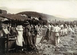
Part of Photographs of Edward Verrell
Black-and-white photograph shows men, women and children stripping hop cones into hessian-covered troughs, carrying baskets and sacks of harvested hops on the extensive hop grounds. The plant was cultivated widely at Glenorchy, Margate, Kingston and the Upper Derwent Valley area.
Photograph of several hop fields bordered by windbreak trees, possibly poplars
Graeme Raphael
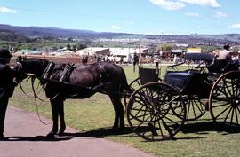
Horse and carriage at Launceston Show 1972
Part of Hal Wyatt Collection
Colour photograph of dark bay or black horse in harness, with a black carriage at Launceston Show, 1972. Groom or driver also dressed in black. Other carriages in background.
Hal Wyatt
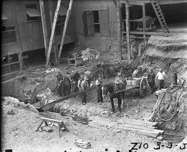
Horse and cart used in excavation of Derwent Prime furnace site at E.Z. Co. Zinc Works
Black-and-white photograph shows horse and cart positioned in pit while men excavate the site of the Derwent Prime furnace by hand at the E.Z. Co Zinc Works 1930
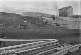
Horse carts and timber at E.Z. Co. Zinc Works
Black-and-white photograph shows stacks of sawn timber and workmen with horses and carts removing earth at an excavation on site E.Z. Co. Zinc Works at Risdon
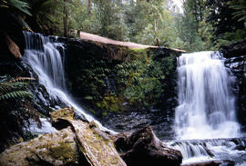
Part of Arthur Knight Slides
An out-of-focus colour photograph shows Horseshoe Falls on the Russell River, above Russell Falls
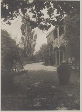
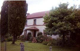
Part of George Musgrave Parker : Correspondence and research records
Photograph of Kelvedon house and garden showing deck chair and urn thought to have been taken c1926-1928
George Musgrave Parker
View through poplar trees of a two-storey cream house with garden in front. Paddocks surround house.
Graeme Raphael
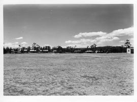
Newly built street of houses in Cadbury Estate, Claremont.
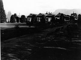
Row of wooden houses on Cadbury Estate with Mount Wellington in background
Houses on the Cadbury Estate, Claremont
Newly constructed wooden homes, Cadbury Village, Claremont.
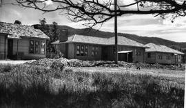
Houses under construction, possibly on the Cadbury Estate.
Houses under construction, Cadbury Estate
Wooden framework constructed for several buildings, trees and hills in background.
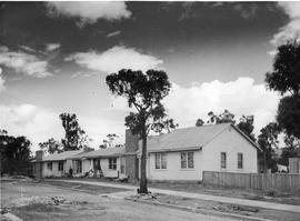
Houses under construction, Cadbury Estate
Woman and child walking across grassy fields, with several houses under construction in background.
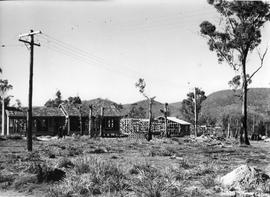
Houses under construction, Cadbury Estate
Employee houses under construction, Cadbury Estate.
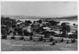
New houses on Cadbury Estate, Claremont. Initials J.C.B. on lower right of photograph, indicate the photograph taken by Joseph. C. Breaden.
Joseph C. Breaden
Part of De La Haye Postcard Collection

Part of Arthur Knight Slides
Colour photograph shows hut at Lake Meston built of logs, shingles and with tin plate chimney People sitting outside hut eating
Part of Arthur Knight Slides
Colour photograph shows the rusting red roofing iron on hut visible above trees on the edge of Twilight Tarn
Hut, barn and wagons at Wihareja
Colour photograph of timber hut, barn and wagons at Wihareja
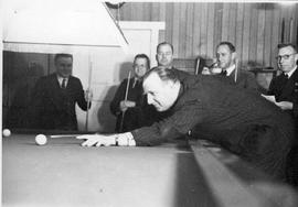
HV McKernan attending social function, 1949
HV McKernan (with cue) and members of the Marketing Conference July 1949.
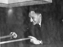
I van Assche attending social function, 1949
I van Assche taking a break from the Marketing Conference July 1949.
Part of Arthur Knight Slides
Colour photograph shows patterned bark of snow gum near Cathedral Mountain

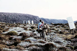
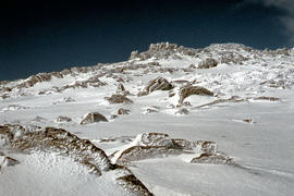
Ice formation near Herods Gate 1978
Part of Arthur Knight Slides
Colour photograph shows ice formation on cliff face near Herods Gate, with snow covering alpine vegetation

Part of Arthur Knight Slides
Colour photograph shows ice formed on plants, location unknown
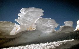
Ice on bushes at Newdegate Pass
Part of Hal Wyatt Collection
Colour photograph of ice on bushes at Newdegate Pass, 1970
Part of Arthur Knight Slides
Colour photograph shows a person standing on ice at Lake Dobson, with ridge of snow above treeline
Part of Arthur Knight Slides
Colour photograph shows two people standing upright on the frozen surface of Lake Dobson, 1954
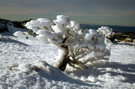
Ice-covered shrubs on Mount Mawson
Part of Arthur Knight Slides
Colour photograph shows ice formation on branches of shrub at Mount Mawson
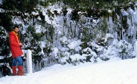
Part of Hal Wyatt Collection
Colour photograph taken near the Springs of man dressed in red beside road to Mount Wellington, with icicles dangling from the vegetation after a snowstorm

Part of Arthur Knight Slides
Colour photograph shows icicles formed on Little Horn 1985
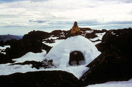
Part of Arthur Knight Slides
Colour photograph shows two bearded men posing on the top or in doorway of an igloo built at Mount Field West, 1975
Inspecting the Soldiers Walk memorial
Group of people gathered at the Soldiers Memorial Avenue, Queens Domain in Hobart. Tasmania.
Graeme Raphael
Interior of cell room at E.Z. Co. Zinc Works
Black-and-white photograph shows interior of cell room at E.Z. Co. Zinc Works at Risdon
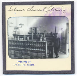
Interior of chemical laboratory at Domain House
Interior of chemical laboratory, Domain House, Hobart.
John Watt Beattie
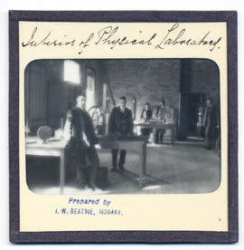
Interior of physical laboratory at the rear of Domain House
Interior of physical laboratory at the rear of Domain House, Hobart.
John Watt Beattie
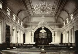
Part of Photographs of Edward Verrell
Black-and-white photograph shows interior of Hobart Town Hall, with low-hanging chandelier and pipe organ
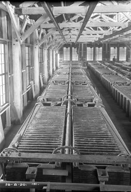
Interior tanks being fitted out in partially constructed building at E.Z. Co. Zinc Works
Black-and-white photograph shows partially completed tanks atop heavy concrete foundations in a building under construction, at E.Z. Co. Zinc Works at Risdon 1924
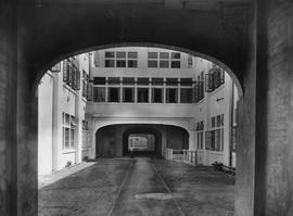
Internal Courtyard, Cadbury Factory
View of road through an internal courtyard, surrounded by multi-storied factory buildings on Cadbury site.
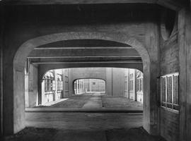
Internal Courtyard, Cadbury Factory
View of road through an internal courtyard linking factory buildings on Cadbury site.
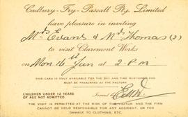
Invitation to visit the Cadbury factory, Claremont
Invitation from Cadbury Fry Pascall to Mrs Evans and Mrs Thomas to visit the Claremont Works on Monday 16th January at 2 p.m.
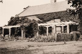
Brick house with ivy growing up wall. Pergola runs length of building, with climbing plants and garden beds below.
Graeme Raphael
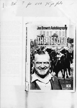
Cover photograph from Joe Brown's autobiographical account of racing and broadcasting (radio and television) 1947-1981, in Melbourne. Published by the Australian Broadcasting Corporation, 1984. Includes photographs, racing statistics and appendices (short articles on Warrnambool racecourse, Phar Lap, Moonee Valley centenary)
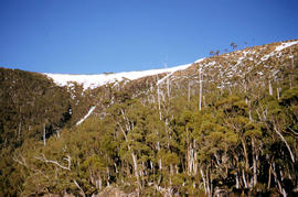
Part of Arthur Knight Slides
Colour photograph shows snow cover on K Col, 1963
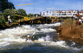
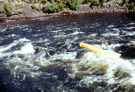
Kayak slalom paddler Jonathan Males
Part of Arthur Knight Slides
Colour photograph shows Australian K1 champion Jonathan Males, a Tasmanian paddler competing at Bradys Lake slalom course, watched by several spectators on a bridge above and alongside the course. The course on Woodwards Canal, a man-made water course carved between Bradys Lake and Bronte Lagoon by the Hydro Electric Commission during construction of a hydro-electric power scheme
Part of Arthur Knight Slides
Colour photograph shows a kayaker falling into the Derwent River, below the site of the Repulse Dam, in 1964
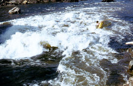
Kayaking in rapids of Derwent River
Part of Arthur Knight Slides
Colour photograph shows a lone kayaker navigating whitewater on the Derwent River below the Repulse Dam site
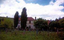
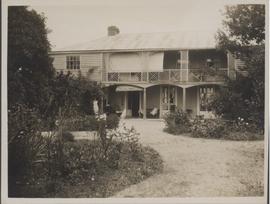
Part of George Musgrave Parker : Correspondence and research records
Photograph of Kelvedon taken by George Musgrave Parker
George Musgrave Parker
Part of George Musgrave Parker : Correspondence and research records
Photograph taken by George Musgrave Parker (see also book ch.3)
George Musgrave Parker
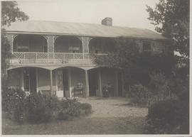
Part of George Musgrave Parker : Correspondence and research records
Photograph of Kelvedon House thought to be taken around 1926
George Musgrave Parker
Part of George Musgrave Parker : Correspondence and research records
Photograph of the distant view of Kelvedon taken over the river from the main road (from Mrs Mitchell)
George Musgrave Parker

Part of Arthur Knight Slides
Colour photograph of limited water flow across Knyvet Falls 1984 GIS: Latitude -4159 Longitude 14593 Gazetteer Australia Record_ID TAS06008

Knyvet Falls near Cradle Mountain
Colour photograph shows water flowing over Knyvet Falls in the Cradle Valley
Part of Arthur Knight Slides
Colour photograph shows low cloud obscuring the forest and ridgelines where Lake Edgar is visible in the distance
Part of Arthur Knight Slides
Colour photograph shows Lake Fenton
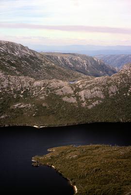
Lake Hanson near Cradle Mountain
Colour photograph shows Lake Hanson, near Cradle Mountain

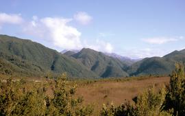
Lake Lea from Prospect Mountain
Part of Arthur Knight Slides
Colour photograph shows Lake Lea from Prospect Mountain near Vale of Belvoir

Lake Loane under snow cover 1978
Part of Arthur Knight Slides
Colour photograph shows Lake Loane beneath blanket of snow, from near the Horse Track 1978

Part of Arthur Knight Slides
Colour photograph shows Lake Timk and Mount Anne in distance GIS: Latitude -4293 Longitude 14646 Gazetteer Australia Record_ID TAS16882
Part of Hal Wyatt Collection
Colour photograph shows mountain range at Crotty, taken 1970.
Hal Wyatt